

ASN Wikibase Occurrence # 191237
This information is added by users of ASN. Neither ASN nor the Flight Safety Foundation are responsible for the completeness or correctness of this information.
If you feel this information is incomplete or incorrect, you can submit corrected information.
| Date: | Sunday 22 May 2016 |
| Time: | 09:33 |
| Type: |  Boeing 737-8AS (WL) |
| Owner/operator: | Ryanair |
| Registration: | EI-DAP |
| MSN: | 33551/1368 |
| Year of manufacture: | 2003 |
| Fatalities: | Fatalities: 0 / Occupants: 165 |
| Aircraft damage: | None |
| Category: | Serious incident |
| Location: | Berlin-Schönefeld Airport (SXF) -
 Germany Germany
|
| Phase: | Approach |
| Nature: | Passenger - Scheduled |
| Departure airport: | Brussel-Zaventem Airport (BRU/EBBR) |
| Berlin-Schönefeld Airport (SXF) | |
| Investigating agency: | BFU |
| Confidence Rating: |
Ryanair flight FR163, a Boeing 737-800 (EI-DAP), and easyJet flight U24553, an Airbus A319 (G-EZEN), were involved in a serious airprox incident at Berlin-Schönefeld Airport in Germany.
The Airbus, bound for Copenhagen, Denmark, had taxied to the hold short line of runway 07L.
At 09:30:21 local time the crew of FR163 was told by the Tower controller that they could expect landing clearance after departure of another flight, the A319.
At 09:32:05, the A319 was cleared for takeoff: “[…] landing is two miles out, wind one five zero degrees, eight knots, runway zero seven left, cleared expedite departure, tschüss […]".
At 09:32:35 flight FR163 was cleared to land: “[…] wind one four zero, eight knots, runway zero seven left, you are cleared to land". This clearance was read back correctly by the flight.
At 09:33:06 flight FR163 reported that they were going around, after which the Tower controller instructed the flight to turn 30 degrees to the right.
Minimum separation distance between the two aircraft was 0,064 NM (119 m) horizontal and 500 ft (152 m) vertical.
The investigation is ongoing.
Sources:
https://www.bfu-web.de/DE/Home/homepage_node.htmlDE/Publikationen/Bulletins/2016/Bulletin2016-05.pdf?__blob=publicationFile
View flight profile image in higher resolution
Images:
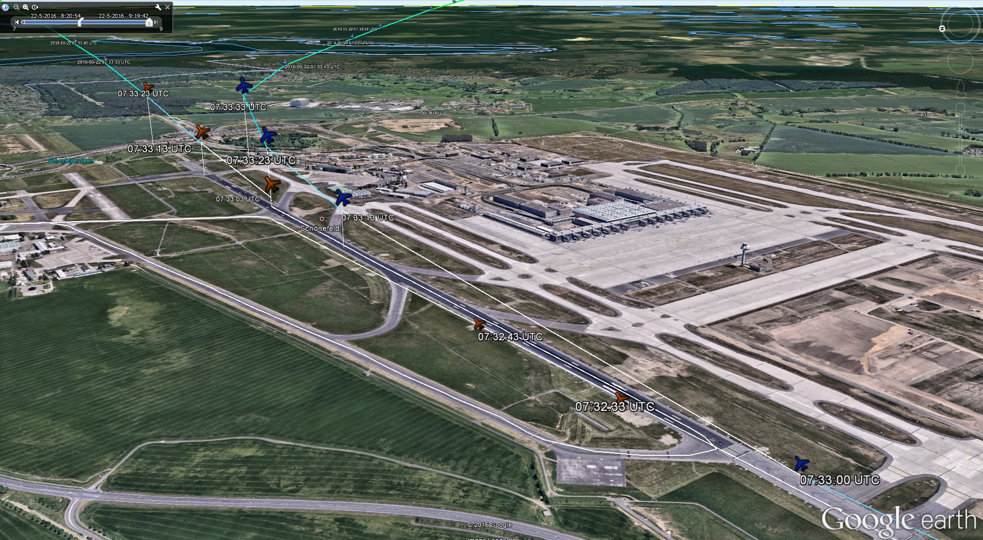
Flight paths based on ADS-B data from Flightradar24.com.
Revision history:
| Date/time | Contributor | Updates |
|---|---|---|
| 08-Nov-2016 20:33 | harro | Added |
| 08-Nov-2016 20:35 | harro | Updated [Narrative, Photo, ] |
| 08-Nov-2016 20:56 | harro | Updated [Source] |
Corrections or additions? ... Edit this accident description
The Aviation Safety Network is an exclusive service provided by:
Quick Links:
| ASN Home | Send Correction / Feedback |
| FSF Home | Disclaimer | Copyright |
| Contact Us | Privacy Policy |
| Press / Media |
 ©2024 Flight Safety Foundation