

ASN Wikibase Occurrence # 201647
This information is added by users of ASN. Neither ASN nor the Flight Safety Foundation are responsible for the completeness or correctness of this information.
If you feel this information is incomplete or incorrect, you can submit corrected information.
| Date: | Wednesday 22 November 2017 |
| Time: | 16:56 |
| Type: |  Cessna 172G Skyhawk |
| Owner/operator: | Private |
| Registration: | N4676L |
| MSN: | 17254671 |
| Year of manufacture: | 1966 |
| Engine model: | Lycoming O-360-A4M |
| Fatalities: | Fatalities: 1 / Occupants: 1 |
| Aircraft damage: | Destroyed |
| Category: | Accident |
| Location: | Rutland County, Pittsford, VT -
 United States of America United States of America
|
| Phase: | En route |
| Nature: | Private |
| Departure airport: | Pittsfield Municipal Airport, MA (KPSF) |
| Middlebury, VT (6B0) | |
| Investigating agency: | NTSB |
| Confidence Rating: |
The 89-year-old commercial pilot departed on a cross-country flight late on the day before Thanksgiving to visit relatives. He received two weather briefings in the 2 days before the flight, with the most recent briefing (the day before the flight) indicating widespread marginal visual flight rules conditions and mountain obscuration; the briefer advised the pilot that visual flight rules (VFR) flight was not recommended. Despite the conditions presented during the weather briefing, the pilot chose to conduct the flight under VFR and indicated to the briefer that he did not want to fly through clouds with potential icing conditions.
GPS track data downloaded from a unit onboard the accident airplane indicated that the flight began uneventfully, with the pilot following a highway, likely for route guidance. As the flight progressed, the airplane's altitude began to decrease. This is consistent with the reported weather conditions and the pilot attempting to remain clear of clouds since he was not on an instrument flight rules flight plan and did not want to fly through the clouds. Near a location where the highway turned west through a town and around terrain, the airplane continued straight and flew along a valley between two ridges. The airplane made two turns within the valley, then made a left turn to the west, possibly in an attempt to return to the highway. While heading toward the highway and after crossing the ridge, the airplane entered a descending right turn. The GPS data ended about 750 ft from the accident site and indicated that the airplane was about 425 ft above ground level. Examination of the airplane, engine, flight controls, and instruments did not reveal any preimpact anomalies that would have precluded normal operation.
Toxicology testing indicated that the pilot had used diphenhydramine, a sedating antihistamine, at some time before the accident; however, the blood level of the potentially impairing medication was below the therapeutic and impairing level. Therefore, it is unlikely that the pilot's use of diphenhydramine contributed to the accident.
Based on the available information, it is likely that the pilot inadvertently encountered instrument meteorological conditions while maneuvering the airplane in deteriorating light conditions near the end of civil twilight. Although the pilot was instrument rated, no determination of his recent instrument flight experience could be made. He was likely not prepared for the sudden entry into instrument conditions and the loss of visibility combined with the turns and varying altitudes while attempting to exit the valley resulted in spatial disorientation and a subsequent loss of airplane control.
Probable Cause: The pilot's decision to continue visual flight into instrument meteorological conditions, which resulted in a loss of control due to spatial disorientation.
Accident investigation:
 |
|
Sources:
NTSB
Location
Images:
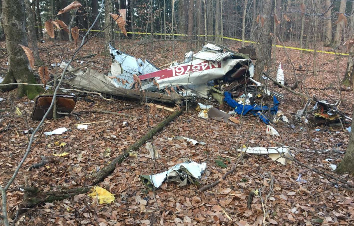
Photo: NTSB
Revision history:
| Date/time | Contributor | Updates |
|---|---|---|
| 23-Nov-2017 17:15 | Geno | Added |
| 23-Nov-2017 18:37 | Captain Adam | Updated [Total fatalities] |
| 23-Nov-2017 19:16 | harro | Updated [Total fatalities, Source, Embed code, Damage] |
| 23-Nov-2017 19:58 | Geno | Updated [Source, Embed code, Narrative] |
| 23-Nov-2017 21:41 | Iceman 29 | Updated [Embed code] |
| 24-Nov-2017 09:31 | Aerossurance | Updated [Operator, Location, Nature, Embed code, Narrative] |
| 02-Mar-2019 14:46 | ASN Update Bot | Updated [Time, Registration, Departure airport, Destination airport, Source, Embed code, Narrative, Accident report, ] |
| 03-Mar-2019 10:46 | harro | Updated [Departure airport, Source, Embed code, Narrative, Photo] |
Corrections or additions? ... Edit this accident description
The Aviation Safety Network is an exclusive service provided by:
Quick Links:
| ASN Home | Send Correction / Feedback |
| FSF Home | Disclaimer | Copyright |
| Contact Us | Privacy Policy |
| Press / Media |
 ©2024 Flight Safety Foundation