

ASN Wikibase Occurrence # 206321
This information is added by users of ASN. Neither ASN nor the Flight Safety Foundation are responsible for the completeness or correctness of this information.
If you feel this information is incomplete or incorrect, you can submit corrected information.
| Date: | Sunday 18 February 2018 |
| Time: | 15:05 |
| Type: |  Socata TBM700 |
| Owner/operator: | Private |
| Registration: | N700VX |
| MSN: | 118 |
| Year of manufacture: | 1997 |
| Total airframe hrs: | 3966 hours |
| Engine model: | P&W PT6A SER |
| Fatalities: | Fatalities: 2 / Occupants: 2 |
| Aircraft damage: | Destroyed |
| Category: | Accident |
| Location: | Uinta County north of Evanston, WY -
 United States of America United States of America
|
| Phase: | Approach |
| Nature: | Private |
| Departure airport: | Tulsa International Airport, OK (TUL/KTUL) |
| Evanston Airport, WY (EVW/KEVW) | |
| Investigating agency: | NTSB |
| Confidence Rating: |
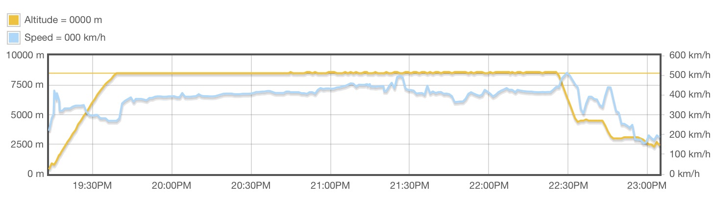
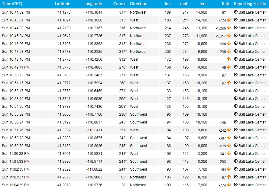
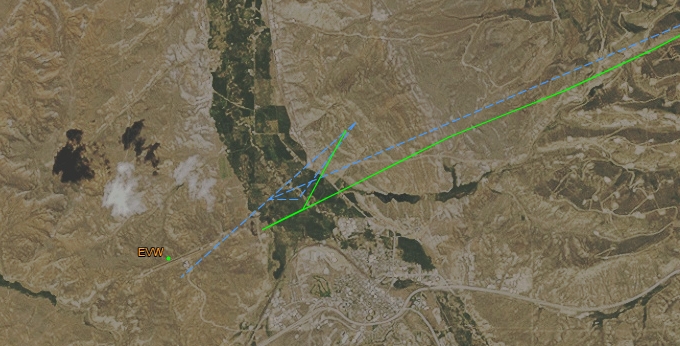
The commercial pilot was conducting an instrument approach following a 3.5-hour cross-country instrument flight rules (IFR) flight in a single-engine turboprop airplane. About 1.6 miles from the runway threshold, the airplane began a climb consistent with the published missed approach procedure; however, rather than completing the slight left climbing turn toward the designated holding point, the airplane continued in an approximate 270° left turn, during which the airplane's altitude varied, before entering a descending right turn and impacting terrain. Tree and ground impact signatures were consistent with a 60° nose-low attitude at the time of impact. No distress calls were received or recorded from the accident flight. A postimpact fire consumed a majority of the cockpit and fuselage.
Weather information for the time of the accident revealed that the pilot was operating in IFR to low IFR conditions with gusting surface winds, light to heavy snow, mist, cloud ceilings between 700 and 1,400 ft above ground level with clouds extending through 18,500 ft, and the potential for low-level wind shear and clear air turbulence. The area of the accident site was under AIRMETs for IFR conditions, mountain obscuration, moderate icing below 20,000 ft, and moderate turbulence below 18,000 ft. In addition, a winter storm warning was issued about 6 hours before the flight departed. Although the pilot received a weather briefing about 17 hours before the accident, there was no indication that he obtained updated weather information before departure or during the accident flight.
Examination of the airframe and engine did not reveal any preimpact anomalies that would have precluded normal operation; however, the extent of the fire damage precluded examination of the avionics system. The airplane was equipped with standby flight instruments.
An acquaintance of the pilot reported that the pilot had experienced an avionics malfunction several months before the accident during which the airplane's flight display went blank while flying an instrument approach. During that occurrence, the pilot used ForeFlight on his iPad to maneuver back to the northeast and fly the approach again using his own navigation. During the accident flight, the airplane appeared to go missed approach, but rather than fly the published missed approach procedure, the airplane also turned left towards to northeast. However, it could not be determined if the pilot's actions were an attempt to fly the approach using his own navigation or if he was experiencing spatial disorientation.
The restricted visibility and turbulence present at the time of the accident provided conditions conducive to the development of spatial disorientation. Additionally, the airplane's turning flight track and steep descent profile are consistent with the known effects of spatial disorientation.
Probable Cause: The pilot's loss of control due to spatial disorientation.
Accident investigation:
 |
|
Sources:
NTSB
https://flightaware.com/live/airport/KEVW
https://flightaware.com/live/flight/N700VX
Location
Images:

Photo(c): NTSB
Media:
Socata TBM 700 plane crashes near Evanston, WY, USA, no survivors, 2 fatalities.https://t.co/HmdhqSwFdz pic.twitter.com/ZTlsDoS9ip
— Planes Of Legend (@PlanesOfLegend) 19 février 2018
Revision history:
| Date/time | Contributor | Updates |
|---|---|---|
| 19-Feb-2018 02:33 | Geno | Added |
| 19-Feb-2018 07:10 | Dmitry | Updated [Aircraft type, Registration, Cn, Operator, Phase, Nature, Departure airport, Destination airport, Source] |
| 19-Feb-2018 09:24 | Iceman 29 | Updated [Time, Departure airport, Destination airport, Source, Embed code, Photo, ] |
| 19-Feb-2018 11:01 | Iceman 29 | Updated [Embed code, Photo, ] |
| 19-Feb-2018 11:02 | Iceman 29 | Updated [Photo, ] |
| 11-Nov-2019 17:42 | ASN Update Bot | Updated [Time, Departure airport, Destination airport, Source, Narrative, Accident report, ] |
| 06-Mar-2022 02:11 | Captain Adam | Updated [Departure airport, Destination airport, Source, Narrative, Category, Photo] |
Corrections or additions? ... Edit this accident description
The Aviation Safety Network is an exclusive service provided by:
Quick Links:
| ASN Home | Send Correction / Feedback |
| FSF Home | Disclaimer | Copyright |
| Contact Us | Privacy Policy |
| Press / Media |
 ©2024 Flight Safety Foundation