

ASN Wikibase Occurrence # 20844
This information is added by users of ASN. Neither ASN nor the Flight Safety Foundation are responsible for the completeness or correctness of this information.
If you feel this information is incomplete or incorrect, you can submit corrected information.
| Date: | Sunday 8 June 2008 |
| Time: | 02:48 |
| Type: |  Bell 407 |
| Owner/operator: | Phi Inc |
| Registration: | N416PH |
| MSN: | 53276 |
| Year of manufacture: | 1998 |
| Total airframe hrs: | 6185 hours |
| Engine model: | Rolls-Royce C-47B |
| Fatalities: | Fatalities: 4 / Occupants: 4 |
| Aircraft damage: | Destroyed |
| Category: | Accident |
| Location: | Sam Houston National Forest, Hunstville, TX -
 United States of America United States of America
|
| Phase: | En route |
| Nature: | Ambulance |
| Departure airport: | Huntsville, TX (TE03) |
| Houston, TX (38TE) | |
| Investigating agency: | NTSB |
| Confidence Rating: |
This report was updated on August 14, 2009.
An Emergency Medical Services (EMS) flight dispatch was requested from the accident operator, since a previous EMS operator had "aborted" the same requested mission flight. The EMS operator, who had "aborted" the same mission approximately one hour and 30 minutes prior to the accident flight, reported low clouds in the vicinity of the accident site. No PIREP was reported with the FAA. Official weather reporting stations in the area recorded visional flight rules weather conditions. The pilot contacted his company's operations control center and discussed observed weather and the reasoning for the "turndown" by the other EMS operator. It was agreed that weather observation stations were reporting visual flight rules weather conditions and the flight was accepted. The EMS flight powered up for the accident leg at 0244:11 and departed at 0246:56. The onboard flight tracking system recorded the flight until 0247 to an altitude of 1,016 feet mean sea level (600 feet above the ground), on a flight path of 170 degrees.
The wreckage was located 2.5 miles southwest of the last known coordinates in densely forested terrain, the next morning, in the exact location where the other EMS operator had encountered low clouds and lost their reference to surface light sources. Sheared tree tops indicate initial impact occurred with the helicopter's main rotor blade system, in a straight, nose low attitude. The flight path terrain was dark, without surface reference lights, and there was no moon. The accident helicopter was equipped with the Aviation Night Vision Imaging System and radar altimeter; however the settings on the radar altimeter could not be established and the pilot was not utilizing night vision goggles. The helicopter was not equipped with Helicopter Terrain Awareness Warning System (HTAWS). The pilot was appropriately trained and certified to fly the accident flight. An examination of the helicopter airframe, engine, and related systems revealed no anomalies.
Probable Cause: The pilot's failure to identify and arrest the helicopter's descent, which resulted in its impact with terrain. Contributing to the accident was the limited outside visual reference due to the dark night conditions.
Accident investigation:
 |
|
Sources:
NTSB
Location
Images:
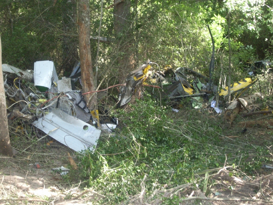
(c) NTSB
Revision history:
| Date/time | Contributor | Updates |
|---|---|---|
| 08-Jun-2008 23:21 | plane freak | Added |
| 08-Jun-2008 23:26 | harro | Updated |
| 08-Jun-2008 23:38 | harro | Updated |
| 09-Jun-2008 10:55 | harro | Updated |
| 13-Jul-2008 11:19 | Fusko | Updated |
| 15-Jan-2009 11:01 | harro | Updated |
| 11-Mar-2013 10:34 | TB | Updated [Operator, Source, Narrative] |
| 21-Dec-2016 19:14 | ASN Update Bot | Updated [Time, Damage, Category, Investigating agency] |
| 21-Dec-2016 19:16 | ASN Update Bot | Updated [Time, Damage, Category, Investigating agency] |
| 21-Dec-2016 19:20 | ASN Update Bot | Updated [Time, Damage, Category, Investigating agency] |
| 03-Dec-2017 11:22 | ASN Update Bot | Updated [Operator, Other fatalities, Departure airport, Destination airport, Source, Narrative] |
Corrections or additions? ... Edit this accident description
The Aviation Safety Network is an exclusive service provided by:
Quick Links:
| ASN Home | Send Correction / Feedback |
| FSF Home | Disclaimer | Copyright |
| Contact Us | Privacy Policy |
| Press / Media |
 ©2024 Flight Safety Foundation