

ASN Wikibase Occurrence # 211307
This information is added by users of ASN. Neither ASN nor the Flight Safety Foundation are responsible for the completeness or correctness of this information.
If you feel this information is incomplete or incorrect, you can submit corrected information.
| Date: | Tuesday 22 May 2018 |
| Time: | 07:28 |
| Type: |  Piper PA-28-140 Cherokee |
| Owner/operator: | Private |
| Registration: | N6177W |
| MSN: | 28-20194 |
| Year of manufacture: | 1964 |
| Total airframe hrs: | 4322 hours |
| Engine model: | Lycoming O-320-E2A |
| Fatalities: | Fatalities: 1 / Occupants: 1 |
| Aircraft damage: | Destroyed |
| Category: | Accident |
| Location: | Chesapeake Regional Airport (KCPK), Roanoke, VA -
 United States of America United States of America
|
| Phase: | Take off |
| Nature: | Private |
| Departure airport: | Norfolk-Chesapeake Regional Airport, VA (KCPK) |
| Farmingdale-Republic Field, NY (FRG/KFRG) | |
| Investigating agency: | NTSB |
| Confidence Rating: |
The commercial pilot completed a normal preflight inspection and engine run-up and received an instrument flight rules clearance from air traffic control to depart from the uncontrolled airport, where fog, low visibility, and clouds were present. Shortly after takeoff, the airplane entered the clouds and fog, climbed on the departure runway heading, and turned right, consistent with the clearance provided; however, the airplane continued the right turn, flying a 360° circle. During the circle, the airplane rapidly descended to about 60 ft above ground level (agl) then climbed to about 600 ft agl. The last radar data point showed the airplane at 356 ft agl, flying at 42 knots groundspeed. There were no communications received from the pilot during the flight. The wreckage was located in an open field about 1/4 mile from the last radar data point.
A postaccident examination of the airplane and the airplane's primary vacuum system did not reveal any anomalies consistent with a preimpact failure or malfunction. The airplane was equipped with a standby vacuum system and an electrically-powered attitude indicator, and the investigation found no anomalies with these components. Due to impact and fire damage, the investigation could not determine whether the standby vacuum system was activated by the pilot.
The restricted visibility, maneuvering, and workload associated with the initial post-takeoff phase of flight provided conditions conducive to the development of spatial disorientation, and the changes in the airplane's altitude, heading, and speed depicted on radar are consistent with the known effects of spatial disorientation. It is likely that the pilot experienced spatial disorientation during the climbing departure turn, which resulted in an exceedance of the airplane's critical angle of attack, an aerodynamic stall, and a subsequent impact with terrain.
Probable Cause: The pilot's loss of airplane control due to spatial disorientation during the departure climb in instrument meteorological conditions.
Accident investigation:
 |
|
Sources:
NTSB
https://flightaware.com/live/flight/N6177W/history/20180522/1100Z/KCPK/KFRG
FAA register: http://registry.faa.gov/aircraftinquiry/NNum_Results.aspx?NNumbertxt=6177W
Location
Images:
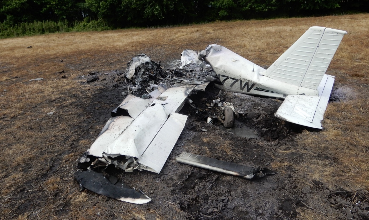
Photo: NTSB
Revision history:
| Date/time | Contributor | Updates |
|---|---|---|
| 22-May-2018 12:53 | gerard57 | Added |
| 22-May-2018 13:13 | Geno | Updated [Location, Source] |
| 22-May-2018 16:14 | gerard57 | Updated [Aircraft type, Operator, Total fatalities, Total occupants, Other fatalities, Source, Narrative] |
| 22-May-2018 16:39 | Geno | Updated [Aircraft type, Registration, Cn, Phase, Departure airport, Destination airport, Source, Damage, Narrative] |
| 22-May-2018 16:40 | Geno | Updated [Aircraft type] |
| 11-Nov-2019 17:42 | ASN Update Bot | Updated [Time, Departure airport, Destination airport, Source, Narrative, Accident report, ] |
| 11-Nov-2019 18:17 | harro | Updated [Source, Narrative, Photo] |
| 11-Nov-2019 18:17 | harro | Updated [Departure airport, Destination airport, Source] |
Corrections or additions? ... Edit this accident description
The Aviation Safety Network is an exclusive service provided by:
Quick Links:
| ASN Home | Send Correction / Feedback |
| FSF Home | Disclaimer | Copyright |
| Contact Us | Privacy Policy |
| Press / Media |
 ©2024 Flight Safety Foundation