

ASN Wikibase Occurrence # 214373
This information is added by users of ASN. Neither ASN nor the Flight Safety Foundation are responsible for the completeness or correctness of this information.
If you feel this information is incomplete or incorrect, you can submit corrected information.
| Date: | Saturday 11 August 2018 |
| Time: | c. 05:20 UTC |
| Type: |  Pacific Aerospace 750XL |
| Owner/operator: | Dimonim Air |
| Registration: | PK-HVQ |
| MSN: | 144 |
| Year of manufacture: | 2008 |
| Fatalities: | Fatalities: 8 / Occupants: 9 |
| Aircraft damage: | Destroyed |
| Category: | Accident |
| Location: | near Oksibil Airport (OKL/WAJO), Papua -
 Indonesia Indonesia
|
| Phase: | Approach |
| Nature: | Passenger - Scheduled |
| Departure airport: | Tanahmerah Airport (TMH/WAKT) |
| Oksibil Airport (OKL/WAJO) | |
| Investigating agency: | NTSC |
| Confidence Rating: |
The PAC 750XL aircraft registered PK-HVQ was being operated by Dimonim Air on an unscheduled passenger flight from Tanahmerah Airport to Oksibil. On the day of the occurrence, the meteorological condition at Oksibil was below the requirement of Visual Flight Rule (VFR) weather minima and did not improve.
Being aware that some pilots had performed flights to Oksibil and returned, the pilot decided to fly to Oksibil.
At 13:42 LT, on daylight conditions, PK-HVQ aircraft departed from Tanahmerah. On board the aircraft were one pilot, one observer pilot and 7 passengers. According to the passenger and cargo manifest, the total weight of passengers and the baggage were 473 kg. Prior to the departure, there was no record or report of aircraft system malfunction.
At 14:11 LT, the pilot made initial contact with Oksibil Tower controller and reported that the aircraft was maintaining an altitude of 7,000 feet and the estimated time arrival at Oksibil would be 05:20 UTC (14:20 LT). The Oksibil Tower controller advised the pilot of the latest meteorological condition that the visibility was 1 up to 2 km and most of the area was covered by cloud.
At 14:16 LT, the pilot reported that the aircraft position was over Oksibil Aiport and the Oksibil Tower controller instructed the pilot to continue the flight to the final runway 11 and to report when the runway was in sight.
The Oksibil Tower controller and pilots of other aircraft called the pilot but no reply. On the following day, the aircraft was found on a ridge of a mountain about 3.8 Nm northwest of Oksibil on bearing 331° with an elevation of about 6,800 feet. Eight occupants were fatally injured and one occupant was seriously injured.
The investigation determined the contributing factors of the occurrence as follows:
- VFR weather minimum requirement that was not implemented properly most likely had made the pilot did not have a clear visual to the surrounding area.
- Considering that the Pilot in Command (PIC) had lack knowledge of the terrain surrounding the Oksibil area, and the absence of voice alert from the TAWS when the aircraft flying close to terrain, resulted in the PIC did not have adequate awareness to the surrounding terrain while flying into clouds and continued to fly below the terrain height until the aircraft impacted the terrain.
Accident investigation:
 |
|
Sources:
www.swissinfo.ch
https://www.miamiherald.com/news/nation-world/article216507710.html?utm_source=dlvr.it&utm_medium=twitter
https://en.antaranews.com/news/117257/aircraft-with-seven-people-on-board-missing-in-papua#.W27zgygTW44.twitter
https://akurat.co/news/id-278780-read-pesawat-pc6-pkhvq-hilang-kontak-di-wilayah-oksibil-papua
www.yahoo.com
___________________
https://www.dimonimair.com/aircraft/turboprops/pac-750-xstol-pk-hvq/
History of this aircraft
Other occurrences involving this aircraft
| 19 October 2011 | ZS-EPV | National Airways Corporation | 0 | Bor Airport |  |
min |
Images:
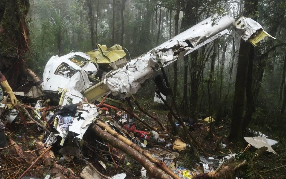
Photo: NTSC
Revision history:
| Date/time | Contributor | Updates |
|---|---|---|
| 11-Aug-2018 12:59 | gerard57 | Added |
| 11-Aug-2018 13:05 | gerard57 | Updated [Aircraft type] |
| 11-Aug-2018 14:22 | Iceman 29 | Updated [Operator, Departure airport, Destination airport, Source, Narrative] |
| 11-Aug-2018 14:23 | Iceman 29 | Updated [Aircraft type] |
| 11-Aug-2018 14:25 | Iceman 29 | Updated [Narrative] |
| 11-Aug-2018 14:35 | Iceman 29 | Updated [Registration, Source] |
| 11-Aug-2018 14:37 | harro | Updated [Aircraft type] |
| 11-Aug-2018 14:40 | Iceman 29 | Updated [Operator, Source] |
| 11-Aug-2018 14:40 | harro | Updated [Aircraft type, Operator, Departure airport, Source, Narrative] |
| 11-Aug-2018 14:51 | harro | Updated [Cn] |
| 11-Aug-2018 15:58 | Iceman 29 | Updated [Source] |
| 11-Aug-2018 20:01 | Iceman 29 | Updated [Time, Source, Narrative] |
| 12-Aug-2018 05:06 | gerard57 | Updated [Total fatalities, Location, Source, Damage, Narrative] |
| 12-Aug-2018 07:37 | Aerossurance | Updated [Location] |
| 12-Aug-2018 07:42 | Aerossurance | Updated [Location] |
| 12-Aug-2018 11:02 | Iceman 29 | Updated [Location, Destination airport, Embed code] |
| 12-Aug-2018 14:12 | Iceman 29 | Updated [Embed code] |
| 15-Aug-2018 20:14 | Anon. | Updated [Cn, Embed code] |
| 17-May-2021 19:07 | harro | Updated [Photo] |
Corrections or additions? ... Edit this accident description
The Aviation Safety Network is an exclusive service provided by:
Quick Links:
| ASN Home | Send Correction / Feedback |
| FSF Home | Disclaimer | Copyright |
| Contact Us | Privacy Policy |
| Press / Media |
 ©2024 Flight Safety Foundation