

ASN Wikibase Occurrence # 222088
This information is added by users of ASN. Neither ASN nor the Flight Safety Foundation are responsible for the completeness or correctness of this information.
If you feel this information is incomplete or incorrect, you can submit corrected information.
| Date: | Thursday 21 February 2019 |
| Time: | 20:04 |
| Type: |  Piper PA-32R-301T Saratoga II TC |
| Owner/operator: | Ironhead II LLC |
| Registration: | N4922K |
| MSN: | 3257064 |
| Year of manufacture: | 1998 |
| Total airframe hrs: | 2759 hours |
| Engine model: | Lycoming TIO-540-AH1A |
| Fatalities: | Fatalities: 1 / Occupants: 1 |
| Aircraft damage: | Destroyed |
| Category: | Accident |
| Location: | Elkhart County, Goshen Municipal Airport (KGSH), Goshen, IN -
 United States of America United States of America
|
| Phase: | Approach |
| Nature: | Private |
| Departure airport: | Goshen Airport, IN (GSH/KGSH) |
| Goshen Airport, IN (GSH/KGSH) | |
| Investigating agency: | NTSB |
| Confidence Rating: |
The Piper PA-32R-301T airplane, N4922K, was destroyed when it was involved in an accident near Goshen, Indiana. The pilot sustained fatal injuries.
The pilot was conducting a practice circling approach in dark night visual meteorological conditions. The published elevation at the destination airport was 827 ft mean sea level (msl), and the published minimum altitude for the circling approach, 1.9 miles from the airport, was 1,460 ft msl. According to radar data, the airplane took off, climbed west, and then turned back to the east. The airplane then started a turn to the north about 1.2 miles east of the airport. Radar recorded the airplane at an altitude of about 1,125 ft msl before radar contact was lost.
An airport security video showed the airplane flying toward the airport at what appeared to be a level attitude, followed by a flash of light; the airplane then disappeared from view. The airplane impacted 250-ft-high power lines about 1.37 miles east of the airport; the elevation at the accident site was about 867 ft msl, and the approximate altitude of the collision with the power lines was 1,117 ft msl. The video also recorded what appeared to be a ground explosion and fire, and the airplane wreckage was located adjacent to damaged power lines.
Evidence of collision with the power lines was observed on the airframe and propeller. Most of the fuselage and cockpit were consumed by a postimpact fire.
PROBABLE CAUSE
The pilot’s failure to maintain adequate altitude for undetermined reasons during a practice circling approach in dark night visual meteorological conditions, which resulted in a collision with power lines.
Accident investigation:
 |
|
Sources:
https://www.wndu.com/content/news/Plane-crashes-near-Goshen-Airport-in-Elkhart-County-506190171.html
https://www.goshennews.com/news/local_news/updated-plane-crash-kills-one-near-goshen/article_be0fed0c-945f-59e9-952f-7d230a44fc7a.html
https://www.southbendtribune.com/news/publicsafety/one-dead-in-thursday-night-plane-crash-near-goshen-municipal/article_a8cbdaf6-2fe8-5cf8-b373-26279053282b.html
https://www.abc57.com/news/faa-says-pilot-did-practice-approaches-before-crash-near-goshen-airport
_________________
https://flightaware.com/live/flight/N4922K/history/20190222/0049Z/KGSH/KGSH
https://registry.faa.gov/aircraftinquiry/NNum_Results.aspx?NNumbertxt=N4922K
https://data.ntsb.gov/carol-repgen/api/Aviation/ReportMain/GenerateNewestReport/99010/pdf
https://uk.flightaware.com/photos/view/1898725-101258853bb978f9ed06ba9b5909ab568ccf80b5/aircrafttype/PA32 (photo)
Location
Images:
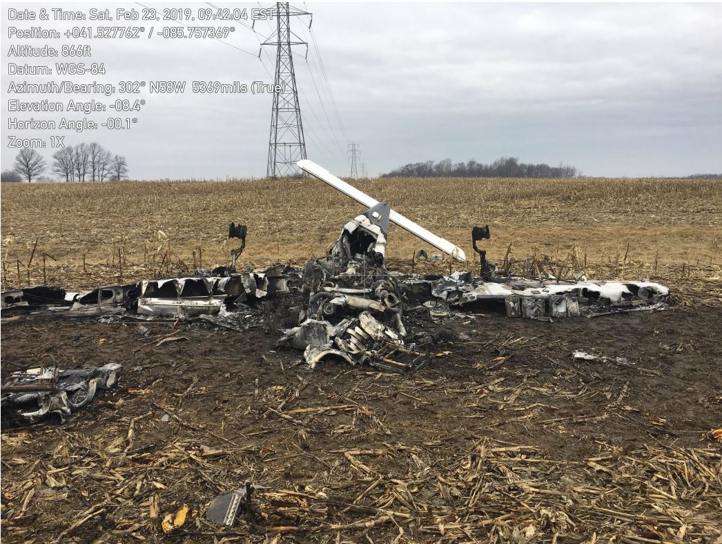
Photo: NTSB
Media:
I’m live in Elkhart County investigating how a fatal plane crash could have impacted people in Noble County. Tune in to @wane15 First News now for the latest. pic.twitter.com/hWsnvo5Mn3
— Michael Kuhn WANE 15 (@michaelkuhnnews) 22 février 2019
Revision history:
| Date/time | Contributor | Updates |
|---|---|---|
| 22-Feb-2019 06:22 | Geno | Added |
| 22-Feb-2019 17:15 | Geno | Updated [Time, Aircraft type, Registration, Cn, Operator, Phase, Departure airport, Destination airport, Source, Narrative] |
| 22-Feb-2019 21:42 | Iceman 29 | Updated [Source, Embed code] |
| 22-Feb-2019 23:00 | RobertMB | Updated [Aircraft type, Registration, Source, Embed code, Narrative] |
| 18-Feb-2022 08:20 | aaronwk | Updated [Time, Nature, Source, Narrative] |
| 18-Feb-2022 08:34 | harro | Updated [Nature, Narrative, Accident report, Photo] |
Corrections or additions? ... Edit this accident description
The Aviation Safety Network is an exclusive service provided by:
Quick Links:
| ASN Home | Send Correction / Feedback |
| FSF Home | Disclaimer | Copyright |
| Contact Us | Privacy Policy |
| Press / Media |
 ©2024 Flight Safety Foundation