

ASN Wikibase Occurrence # 225069
This information is added by users of ASN. Neither ASN nor the Flight Safety Foundation are responsible for the completeness or correctness of this information.
If you feel this information is incomplete or incorrect, you can submit corrected information.
| Date: | Monday 13 May 2019 |
| Time: | 12:21 LT |
| Type: |  de Havilland Canada DHC-2 Beaver Mk I |
| Owner/operator: | Mountain Air Service LLC |
| Registration: | N952DB |
| MSN: | 237 |
| Year of manufacture: | 1951 |
| Fatalities: | Fatalities: 5 / Occupants: 5 |
| Other fatalities: | 1 |
| Aircraft damage: | Destroyed |
| Category: | Accident |
| Location: | Coon Cove near George Inlet area, about 8nm from Ketchikan, AK -
 United States of America United States of America
|
| Phase: | Manoeuvring (airshow, firefighting, ag.ops.) |
| Nature: | Passenger - Non-Scheduled/charter/Air Taxi |
| Departure airport: | Rudyerd Bay, AK |
| Ketchikan Harbor Seaplane Base, AK (WFB) | |
| Investigating agency: | NTSB |
| Confidence Rating: |
A float-equipped DHC-3 Turbine Otter (N959PA of Taquan Air) and a float-equipped DHC-2 Beaver (N952DB of Mountain Air Service) collided in midair, about 7 miles northeast of Ketchikan, Alaska, USA. The five occupants of the DHC-2 sustained fatal injuries. The DHC-3 pilot sustained minor injuries, nine passengers sustained serious injuries, and one passenger sustained fatal injuries.
The purpose of both flights was to transport passengers to Ketchikan from the Misty Fjords National Monument area in Alaska, USA. Both flights were converging on a scenic waterfall before returning to the Ketchikan Harbor Seaplane Base.
At 12:17:15, the DHC-3 was about level at 4,000 ft mean sea level (msl) on a track of 225°, and the DHC-2 was 4.2 nautical miles south of the DHC-3, climbing through 2,800 ft msl, on a track of 255°. About 12:19, the DHC-3 started a descent from 4,000 ft msl, and the DHC-2 was at 3,175 ft msl and climbing. During the next 1 minute 21 seconds, the DHC-3 continued to descend on a track between 224° and 237°, and the DHC-2 leveled out at 3,350 ft msl on a track of about 255°. The airplanes collided at 12:21:14 at an altitude of 3,350 ft msl, 7.4 nm northeast of Ketchikan Harbor.
The DHC-3 pilot stated to the NTSB that the flight from the Misty Fjords area had proceeded normally, and he had descended and was maneuvering the airplane to show passengers a waterfall near Mahoney Lake when the collision occurred. Just prior to the collision, he saw a flash from his left side, and experienced a large, loud impact. According to the pilot, the DHC-3 airplane then rolled right and pitched about 40 degrees nose down toward the water in George Inlet. The pilot stated that he was able to maintain some control and flare the airplane prior to impact. The pilot, some passengers, and some bystanders helped the passengers of the DHC-3 evacuate the airplane and move to the shore. The DHC-3 main wreckage came to rest about 80 ft underwater about 400 ft off the east shore of George Inlet.
The DHC-2 airplane broke up in-flight after the collision, and the wreckage was scattered over water and mountainous tree-covered terrain northeast of Mahoney Lake on the west shore of George Inlet.
Both aircraft were ADS-B-equipped and both pilots were presented with visual traffic information through the iPad with ForeFlight app (DHC-2) and Chelton display (DHC-3). However, the Garmin GSL 71 on the DHC-3 had been turned off, causing pressure altitude of the airplane not to be transmitted with the ADS-B data. Thus, both systems were not able to generate warnings of potential conflicts.
Additionally, the DHC-2 was obscured from the Otter pilot's vision by the window frame until the very last moment. The Beaver pilot likely was unable to see the Otter approaching from behind due to the aircraft structure and the passenger seated on his right.
Probable Cause:
The National Transportation Safety Board determines that the probable cause of this accident was the inherent limitations of the see-and-avoid concept, which prevented the two pilots from seeing the other airplane before the collision, and the absence of visual and aural alerts from both airplanes’ traffic display systems, while operating in a geographic area with a high concentration of air tour activity. Contributing to the accident were (1) the Federal Aviation Administration’s provision of new transceivers that lacked alerting capability to Capstone Program operators without adequately mitigating the increased risk associated with the consequent loss of the previously available alerting capability and (2) the absence of a requirement for airborne traffic advisory systems with aural alerting among operators who carry passengers for hire.
Accident investigation:
 |
|
Sources:
https://www.ktva.com/story/40467807/2-planes-crash-in-waters-near-ketchikan
https://www.ktuu.com/content/news/Authorities-working-to-rescue-victims-of-two-float-plane-crashes-near-Ketchikan-509872001.html
https://vancouversun.com/news/world/five-dead-as-floatplanes-collide-midair-in-ketchikan-alaska
https://www.adn.com/alaska-news/aviation/2019/05/13/2-floatplanes-crash-near-ketchikan-coast-guard-says/
https://eu.usatoday.com/story/news/nation/2019/05/13/alaska-floatplanes-crash-rescue-crews-search/1194789001/
https://7news.com.au/news/disaster-and-emergency/alaska-seaplane-crash-five-killed-as-two-planes-collide-mid-air-c-111105
https://www.news4jax.com/news/national/3-killed-3-missing-in-alaska-plane-collision?utm_source=twitter&utm_medium=social&utm_campaign=snd&utm_content=wjxt4
https://www.cbsnews.com/amp/news/sightseeing-airplanes-carrying-tourists-collide-ketchikan-alaska-live-updates-2019-05-13/
https://edition.cnn.com/2019/05/13/us/alaska-plane-collision/index.html
https://globalnews.ca/news/5280526/bc-woman-killed-alaska-plane-crash-us-husband/
NTSB
Data____________________________________
https://registry.faa.gov/aircraftinquiry/NNum_Results.aspx?NNumbertxt=N952DB
https://flightaware.com/photos/view/4340457-e6d45ba26d4841502e251eb22cb74af456749fb8/aircrafttype/BE33
https://www.mtnairservice.com/
NTSB___________________________________
https://app.ntsb.gov/pdfgenerator/ReportGeneratorFile.ashx?EventID=20190514X70427&AKey=2&RType=Prelim&IType=MA
https://www.flickr.com/photos/ntsb/46943497085/in/album-72157708604728194/
Location
Images:

(c) Dean Straw, 11 August 2013 at Misty Fjords

N952DB departing from Ketchikan Harbour. June 2018

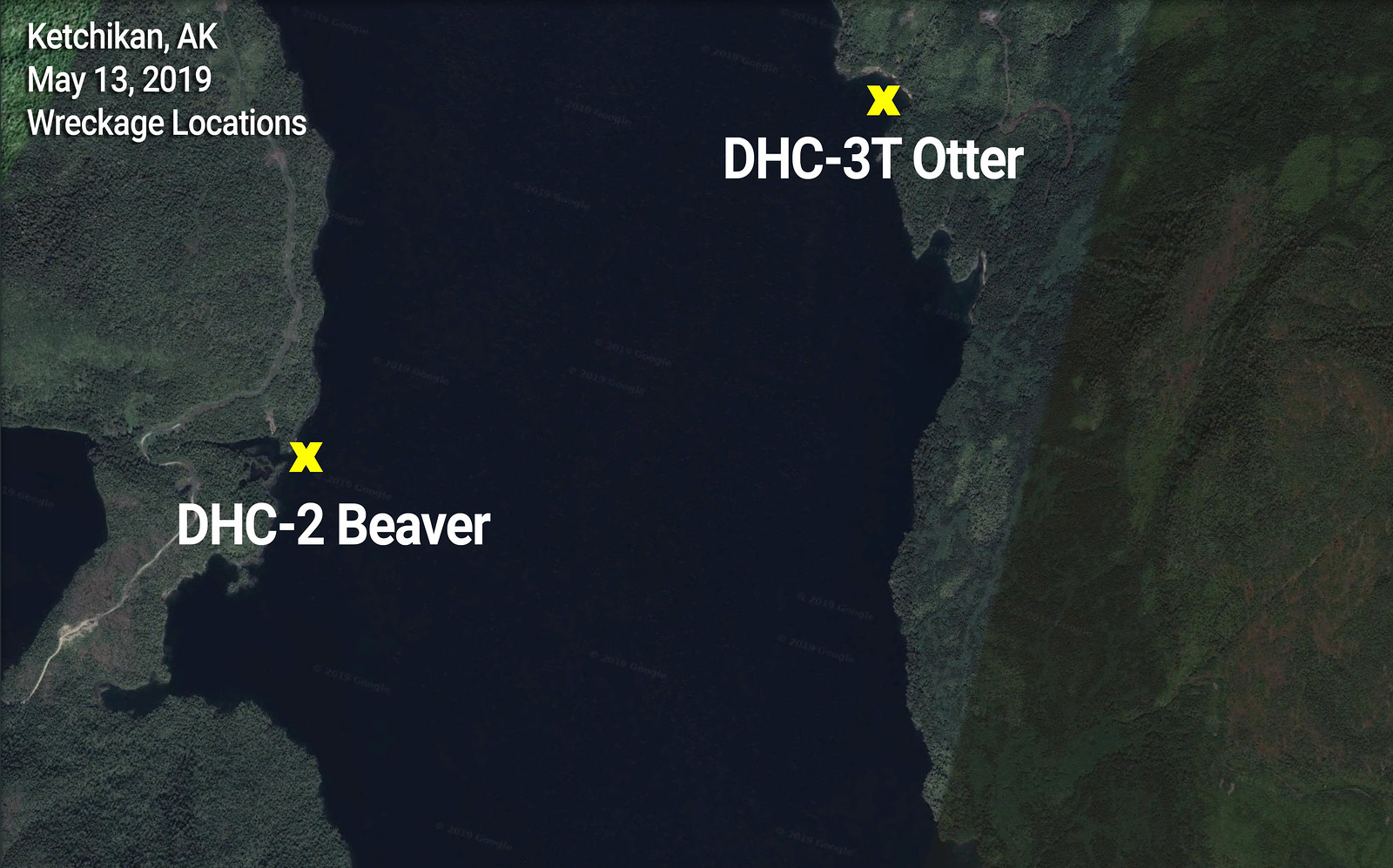
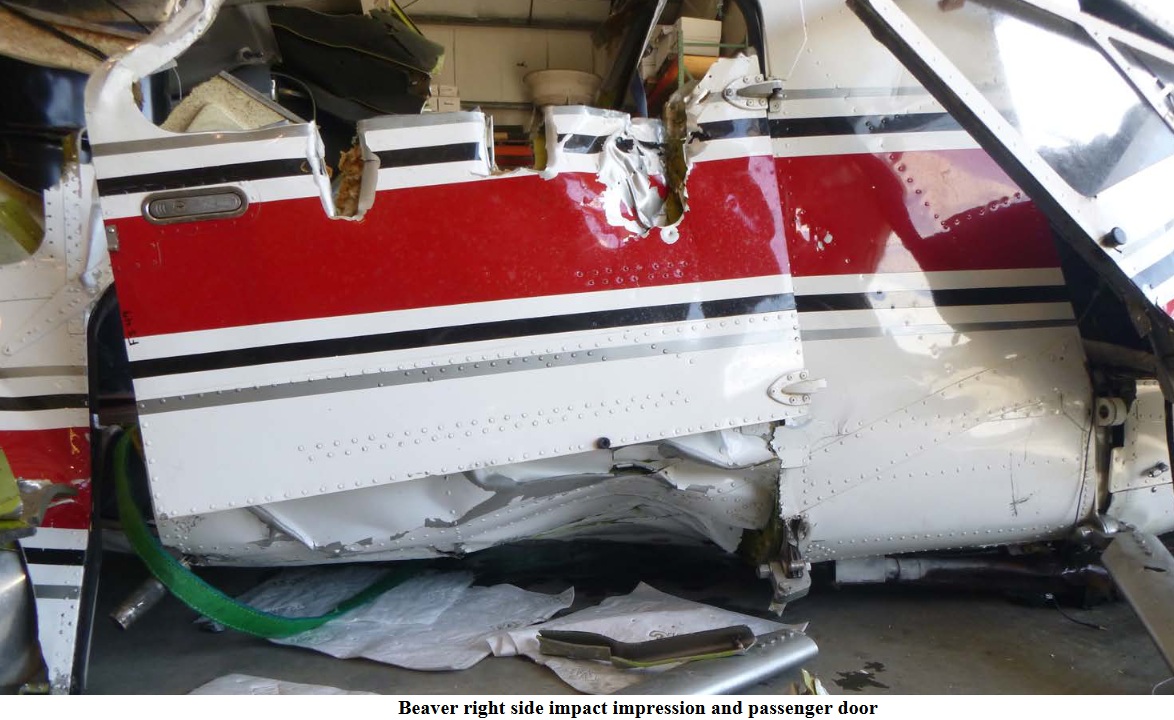
Photo: NTSB
Media:
Revision history:
| Date/time | Contributor | Updates |
|---|---|---|
| 14-May-2019 00:24 | Geno | Added |
| 14-May-2019 00:39 | Captain Adam | Updated [Narrative] |
| 14-May-2019 00:41 | RobertMB | Updated [Aircraft type, Narrative] |
| 14-May-2019 00:56 | Captain Adam | Updated [Narrative] |
| 14-May-2019 04:04 | RobertMB | Updated [Total fatalities, Location, Phase, Nature, Source, Narrative] |
| 14-May-2019 05:07 | Iceman 29 | Updated [Source, Embed code, Narrative] |
| 14-May-2019 05:48 | Iceman 29 | Updated [Embed code] |
| 14-May-2019 06:03 | RobertMB | Updated [Embed code, Narrative] |
| 14-May-2019 06:15 | Iceman 29 | Updated [Photo] |
| 14-May-2019 08:35 | Iceman 29 | Updated [Source, Damage, Narrative] |
| 14-May-2019 10:03 | Iceman 29 | Updated [Source, Narrative] |
| 14-May-2019 13:46 | RobertMB | Updated [Narrative] |
| 14-May-2019 14:23 | Geno | Updated [Time, Registration, Cn, Operator, Source] |
| 14-May-2019 14:40 | RobertMB | Updated [Aircraft type] |
| 14-May-2019 14:54 | RobertMB | Updated [Source, Narrative] |
| 14-May-2019 17:28 | Geno | Updated [Departure airport, Destination airport, Source] |
| 15-May-2019 05:52 | harro | Updated [Time, Other fatalities, Phase, Narrative] |
| 15-May-2019 06:05 | harro | Updated [Embed code, Photo] |
| 15-May-2019 08:32 | fulmar01 | Updated [Photo] |
| 15-May-2019 13:06 | gerard57 | Updated [Other fatalities] |
| 15-May-2019 19:29 | Iceman 29 | Updated [Embed code] |
| 16-May-2019 12:19 | Iceman 29 | Updated [Embed code, Photo] |
| 16-May-2019 12:20 | Iceman 29 | Updated [Embed code, Photo] |
| 16-May-2019 12:23 | Iceman 29 | Updated [Source, Embed code, Photo] |
| 16-May-2019 12:52 | Iceman 29 | Updated [Source, Embed code] |
| 21-May-2019 17:56 | harro | Updated [Source] |
| 22-May-2019 18:59 | harro | Updated [Time, Departure airport, Destination airport, Source] |
| 24-May-2019 11:57 | martin1967 | Updated [Source] |
| 29-Aug-2019 18:56 | Anon. | Updated [Narrative] |
| 17-Aug-2020 12:37 | harro | Updated [Embed code, Narrative, Photo] |
| 21-Apr-2021 08:37 | harro | Updated [Embed code, Narrative] |
| 13-May-2021 18:27 | harro | Updated [Accident report] |
Corrections or additions? ... Edit this accident description
The Aviation Safety Network is an exclusive service provided by:
Quick Links:
| ASN Home | Send Correction / Feedback |
| FSF Home | Disclaimer | Copyright |
| Contact Us | Privacy Policy |
| Press / Media |
 ©2024 Flight Safety Foundation