

ASN Wikibase Occurrence # 230088
This information is added by users of ASN. Neither ASN nor the Flight Safety Foundation are responsible for the completeness or correctness of this information.
If you feel this information is incomplete or incorrect, you can submit corrected information.
| Date: | Sunday 20 October 2019 |
| Time: | 08:45 LT |
| Type: |  Piper PA-24 Comanche |
| Owner/operator: | private |
| Registration: | N7742P |
| MSN: | 24-2956 |
| Year of manufacture: | 1961 |
| Total airframe hrs: | 3651 hours |
| Engine model: | Lycoming O&VO-360 SER |
| Fatalities: | Fatalities: 2 / Occupants: 2 |
| Aircraft damage: | Substantial |
| Category: | Accident |
| Location: | South of Angel Fire Airport (KAXX), Angel Fire, NM -
 United States of America United States of America
|
| Phase: | Take off |
| Nature: | Private |
| Departure airport: | Angel Fire Airport, NM (AXX/KAXX) |
| Great Bend Airport, KS (GBD/KGBD) | |
| Investigating agency: | NTSB |
| Confidence Rating: |
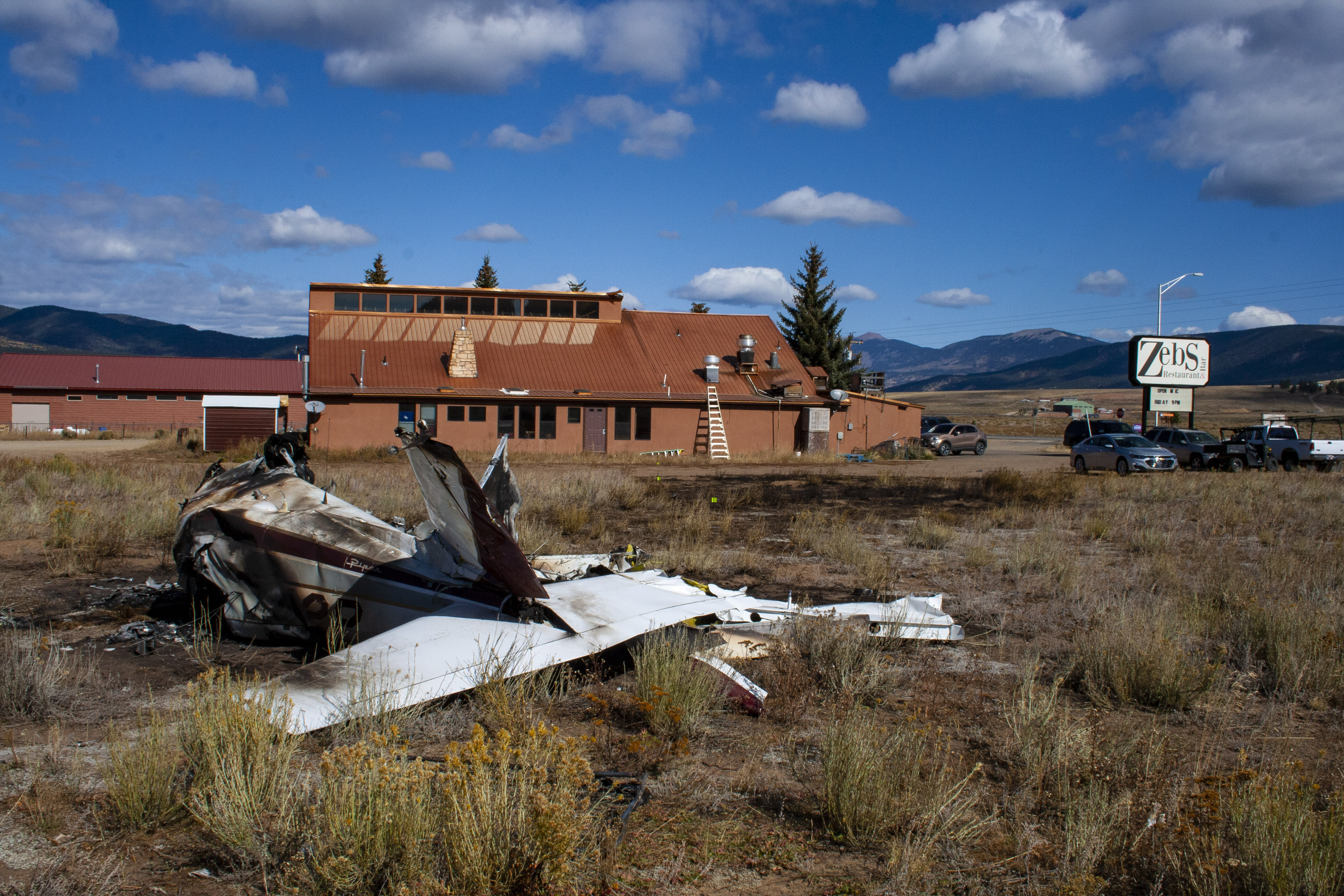
The pilot and passenger were departing on a personal flight from the high elevation airport. Friends of the pilot reported that this was his first time flying into the airport and that he wanted to depart to the south and head back toward the airport because of the wind and to gain altitude. An eyewitness who was driving saw the airplane flying from the airport as it appeared to be struggling to remain in flight. The airplane turned to fly over the road and toward the eyewitness, who thought it was preparing to land. As the airplane approached, it pitched up and turned to the west to avoid power lines crossing the road. The airplane impacted trees, a building and terrain, sustaining substantial damage. Several other witnesses saw the airplane as is departed the airport and described the airplane as unstable.
A security camera, located along the road, captured the airplane flying wings level with the landing gear extended, over the road about 50 ft above ground level. As the airplane approached the light poles and power lines, the airplane banked right and traveled behind trees and buildings out of view. It is likely that the pilot was maneuvering the airplane to land on the road.
The calculated density altitude about the time of the accident was 9,360 ft, which would have reduced the airplane's climb performance. Wind was from the west at 9 knots gusting to 21 knots. After the airplane departed the airport to the south toward rising terrain, the airplane turned east over a road, changing the direction of wind to a tailwind, which would have also reduced the airplane's climb performance by decreasing the airplane's airspeed. The airplane was also topped with fuel which likely put the airplane near its maximum allowable weight for takeoff. Given these conditions, it is unlikely that the airplane was capable of clearing the rising terrain on the day of the accident.
Postaccident examination of the airframe and engine revealed no anomalies that would have precluded normal operation. In addition, airplane damage signatures, witness accounts, and a video indicated that the engine was producing power at the time of the accident.
Medical evidence showed that the pilot had heart disease, which placed him at increased risk of a sudden impairing or incapacitating cardiac event. However, operational evidence (such as the pilot's maneuvering to avoid obstacles and attempt to navigate to a suitable landing site) is inconsistent with sudden impairment or incapacitation; therefore, it is unlikely that the pilot's heart disease contributed to the accident.
Probable Cause: The airplane's degraded performance due to high-density altitude and gusting wind conditions, which resulted in its inability to maintain altitude during the initial takeoff climb. Contributing to the accident was the pilot's lack of experience with high altitude flying and his decision to depart in high-density altitude and gusting wind conditions.
Accident investigation:
 |
|
Sources:
NTSB WPR20FA008
FAA register: https://registry.faa.gov/aircraftinquiry/NNum_Results.aspx?NNumbertxt=7742P
https://flightaware.com/photos/view/87575-92374638d2611f971e680671a8a4e18b5c9b70c0/aircrafttype/PA24
Location
Images:
Media:
Aftermath of a deadly plane crash in Angel Fire this morning. It clipped Zeb’s Restaurant and left a piece of the wing on the roof. We’ll bring you the latest at 10. @KOB4 pic.twitter.com/SCIT2jF91y
— Kassi Nelson (@kassiKOB) October 21, 2019
Revision history:
| Date/time | Contributor | Updates |
|---|---|---|
| 20-Oct-2019 18:35 | Captain Adam | Added |
| 20-Oct-2019 20:27 | Iceman 29 | Updated [Source] |
| 20-Oct-2019 22:37 | Geno | Updated [Time, Location, Phase, Departure airport, Source] |
| 21-Oct-2019 00:59 | Geno | Updated [Registration, Cn, Operator, Source] |
| 21-Oct-2019 04:35 | RobertMB | Updated [Aircraft type, Location, Phase, Nature, Source, Narrative] |
| 21-Oct-2019 05:34 | Anon. | Updated [Source] |
| 21-Oct-2019 18:07 | Iceman 29 | Updated [Source, Embed code] |
| 06-Nov-2019 12:48 | Distresfa | Updated [Embed code] |
| 21-Jan-2020 18:31 | Anon. | Updated [Source, Photo] |
| 09-Sep-2022 13:53 | ASN Update Bot | Updated [Time, Operator, Other fatalities, Nature, Destination airport, Source, Damage, Narrative, Category, Accident report] |
| 09-Sep-2022 13:57 | harro | Updated [Operator, Other fatalities, Source, Narrative] |
Corrections or additions? ... Edit this accident description
The Aviation Safety Network is an exclusive service provided by:
Quick Links:
| ASN Home | Send Correction / Feedback |
| FSF Home | Disclaimer | Copyright |
| Contact Us | Privacy Policy |
| Press / Media |
 ©2024 Flight Safety Foundation