

ASN Wikibase Occurrence # 230926
This information is added by users of ASN. Neither ASN nor the Flight Safety Foundation are responsible for the completeness or correctness of this information.
If you feel this information is incomplete or incorrect, you can submit corrected information.
| Date: | Tuesday 26 November 2019 |
| Time: | 17:35 |
| Type: |  Cirrus SR22 |
| Owner/operator: | Baron von Speed LLC |
| Registration: | N7GA |
| MSN: | 0015 |
| Year of manufacture: | 2001 |
| Engine model: | Continental IO-550-N |
| Fatalities: | Fatalities: 3 / Occupants: 3 |
| Aircraft damage: | Destroyed |
| Category: | Accident |
| Location: | Gass Peak north of North Las Vegas Airport (KVGT), NV -
 United States of America United States of America
|
| Phase: | En route |
| Nature: | Private |
| Departure airport: | Lake Havasu City Airport, AZ (KHII) |
| Las Vegas-North Air Terminal, NV (VGT/KVGT) | |
| Investigating agency: | NTSB |
| Confidence Rating: |
The pilot was conducting a visual flight rules (VFR) personal flight with two passengers during dark night conditions. Prior to the flight, the pilot had filed and subsequently activated a VFR flight plan from his point of departure to his intended destination.
As the pilot neared his intended destination, he contacted Nellis Air Traffic Control Facility and reported his altitude of 6,500 ft and that he had the weather at his destination airport. He also requested a practice instrument landing system (ILS) approach. The controller acknowledged the request and advised the pilot to expect the ILS approach. Throughout the following 7 minutes, the controller issued various heading changes to the pilot due to departing traffic at a nearby Air Force base, which the pilot acknowledged. The controller then issued the pilot a left turn to a westerly heading and informed the pilot that altitude was his discretion, which the pilot acknowledged.
About 1 minute, 54 seconds later, the pilot transmitted “we’re getting a low altitude alert for N7GA, we gotta turn left.” Shortly after, the controller instructed the pilot to “turn left heading 250°,” which the pilot acknowledged. No further communications from the pilot were received despite multiple attempts from the controller. Throughout this timeframe, recorded radar data showed the airplane at an altitude of 6,500 ft msl.
The airplane impacted mountainous terrain at an elevation of 6,500 ft msl, about 400 ft below the peak. The wreckage was fragmented and mostly consumed by fire. Examination revealed no anomalies with the airframe or engine that would have precluded normal operation.
Based on the available evidence, it is likely that the pilot had some sort of terrain awareness warning available; however, it was undetermined what type of system it was. While the pilot reported that he received a “low altitude alert” from an unknown source about 22 seconds before the last radar target, it’s likely that the pilot did not have sufficient time to maneuver to avoid terrain.
Probable Cause: The pilot’s failure to maintain clearance from terrain during cruise flight in dark night conditions.
Accident investigation:
 |
|
Sources:
https://www.8newsnow.com/news/local-news/aircraft-reportedly-crashes-near-decatur-iron-mountain-in-northwest-valley/
https://bnonews.com/index.php/2019/11/small-plane-crashes-into-mountain-north-of-las-vegas/
https://www.fox5vegas.com/news/las-vegas-police-investigate-plane-crash-on-peak-north-of/article_9b03ca80-10ba-11ea-9dac-ef6f2c85403f.html
https://www.fox5vegas.com/news/las-vegas-fire-police-respond-to-small-plane-crash-reports/article_9b03ca80-10ba-11ea-9dac-ef6f2c85403f.html
NTSB
https://flightaware.com/live/flight/N7GA/history/20191127/0043Z/KHII/L%2036.39740%20-115.17300
https://www.flightradar24.com/data/aircraft/n7ga#22fca3ac
Location
Images:

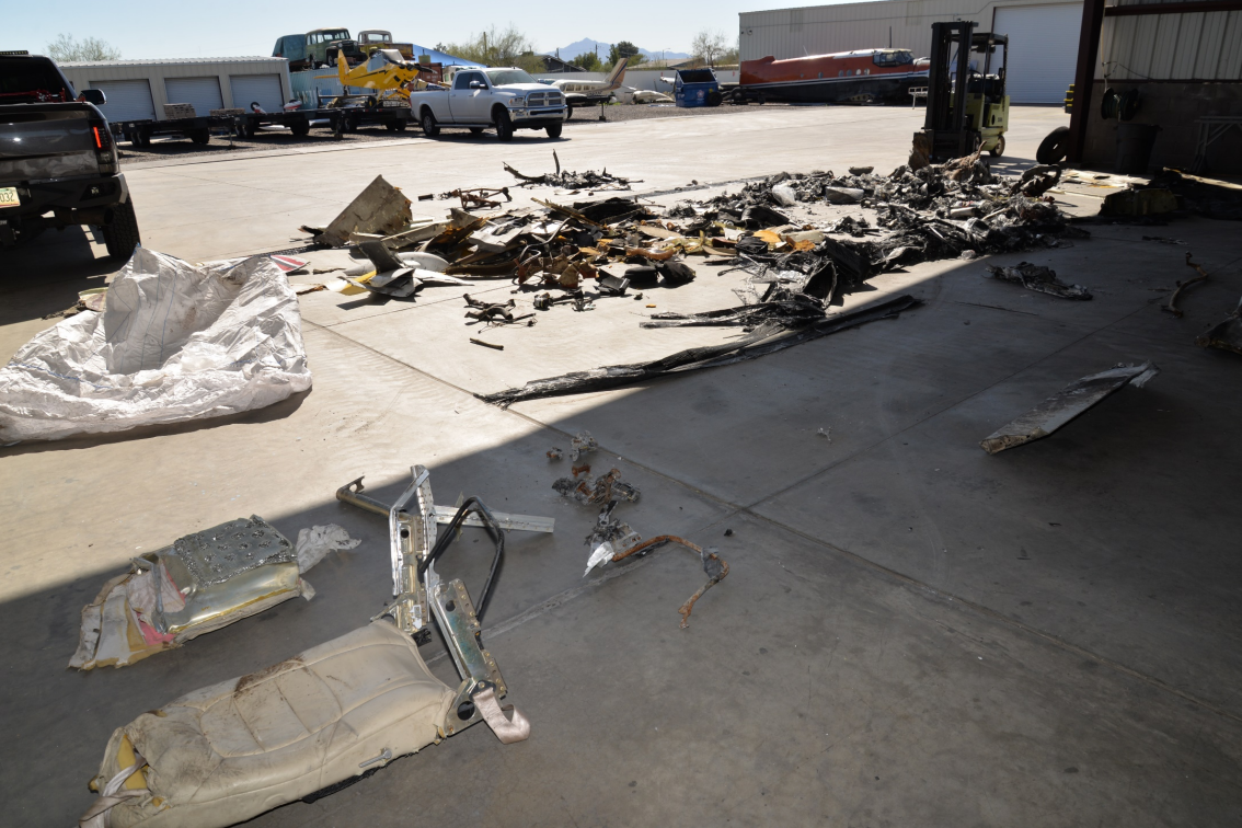
Photo(c): NTSB
Revision history:
| Date/time | Contributor | Updates |
|---|---|---|
| 27-Nov-2019 03:42 | Geno | Added |
| 27-Nov-2019 03:45 | Geno | Updated [Source] |
| 27-Nov-2019 04:34 | RobertMB | Updated [Total fatalities, Total occupants, Nature, Source, Narrative] |
| 27-Nov-2019 12:21 | harro | Updated [Location] |
| 27-Nov-2019 14:10 | RobertMB | Updated [Registration, Cn, Operator, Location, Departure airport, Destination airport, Source, Narrative] |
| 27-Nov-2019 14:11 | RobertMB | Updated [Location] |
| 27-Nov-2019 16:24 | Radio Operator | Updated [Narrative] |
| 27-Nov-2019 16:36 | harro | Updated [Registration, Cn, Operator, Departure airport, Source, Narrative, Photo] |
| 28-Nov-2019 15:43 | Anon. | Updated [Destination airport] |
| 29-Nov-2019 07:03 | Anon. | Updated [Source] |
| 11-Dec-2019 17:03 | Anon. | Updated [Narrative] |
| 13-Mar-2022 04:06 | Captain Adam | Updated [Destination airport, Source, Narrative, Category, Accident report, Photo] |
Corrections or additions? ... Edit this accident description
The Aviation Safety Network is an exclusive service provided by:
Quick Links:
| ASN Home | Send Correction / Feedback |
| FSF Home | Disclaimer | Copyright |
| Contact Us | Privacy Policy |
| Press / Media |
 ©2024 Flight Safety Foundation