

ASN Wikibase Occurrence # 230989
This information is added by users of ASN. Neither ASN nor the Flight Safety Foundation are responsible for the completeness or correctness of this information.
If you feel this information is incomplete or incorrect, you can submit corrected information.
| Date: | Friday 29 November 2019 |
| Time: | 19:11 |
| Type: |  Piper PA-31-350 Navajo Chieftain |
| Owner/operator: | Fly 4 You Inc dba. Security Aviation |
| Registration: | N4087G |
| MSN: | 31-8152127 |
| Year of manufacture: | 1981 |
| Total airframe hrs: | 5502 hours |
| Engine model: | Lycoming LTIO-540-J2BD |
| Fatalities: | Fatalities: 3 / Occupants: 3 |
| Aircraft damage: | Destroyed |
| Category: | Accident |
| Location: | near Cooper Landing, AK -
 United States of America United States of America
|
| Phase: | En route |
| Nature: | Ambulance |
| Departure airport: | Anchorage-Ted Stevens International Airport, AK (ANC/PANC) |
| Seward Airport, AK (SWD/PAWD) | |
| Investigating agency: | NTSB |
| Confidence Rating: |
On November 29, 2019, about 1911 Alaska standard time, a Piper PA-31-350 airplane, N4087G, was destroyed by impact and postcrash fire when it collided with mountainous terrain about 15 miles west of Cooper Landing, Alaska. The three occupants; the airline transport pilot, a flight nurse, and the flight paramedic were fatally injured. The airplane was operated by Fly 4 You Inc., doing business as Security Aviation, as a Title 14 Code of Federal Regulations Part 135 visual flight rules air ambulance flight. Dark night visual meteorological conditions existed at the departure and destination locations and company flight following procedures were in effect. The flight departed Ted Stevens International Airport (PANC), Anchorage, Alaska, about 1848, destined for Seward Airport (PAWD), Seward, Alaska.
Emergency clinic personnel contacted multiple air ambulance companies prior to contacting the accident operator, requesting air ambulance transportation of a patient. The first company contacted turned down the flight due to limited daylight hours. The second company declined the flight due to poor weather conditions.
After accepting the flight, the pilot departed at night, destined for an airport about 75 nautical miles away. The route of flight would take the flight across a peninsula and a mountain range. The destination airport was at the north end of a fjord surrounded by mountains ranging from 4,000 ft to 6,000 ft elevation; for this reason, the destination airport prohibited instrument approaches at night.
Radar data indicated the accident airplane departed and flew south about 3,000 ft mean sea level (msl) toward a highway. The airplane then descended to 2,200 ft msl while flying a right racetrack pattern before flying into a valley. The last data point indicated the airplane was over the west end of a lake at 2,100 ft msl, on a 127° course, and 122 kts groundspeed.
Witnesses reported that they saw the lights of the airplane flying over the highway that night. One witness stated that he saw the airplane west of the mountains turn in a circle as it descended and then entered the valley. Another witness reported seeing the airplane flying low before it impacted the mountain and a post-crash fire ensued.
The airplane impacted the mountain at an elevation of about 1,425 ft msl in an area of steep, heavily tree-covered terrain near the southeast end of a lake. The airplane was highly fragmented and burned; however, all major airplane components were accounted for at the accident site.
Postaccident examination of the engine revealed no evidence of any preimpact mechanical malfunctions or failures that would have precluded normal operation.
Weather simulations conducted after the accident indicated east to southeast winds above the accident site with wind speeds between 30 to 50 knots, downdrafts and updrafts with magnitudes of +/- 1,500 fpm, and relative humidity values above 90% at the mountain tops. Witness reports corroborated this information and also described precipitation and mountain obscuration.
Airman's Meteorological Information (AIRMET) reports were active for the accident region that warned pilots of low-level wind shear (LLWS) conditions, moderate icing conditions between 6,000 and 15,000 ft, and occasional instrument flight rules (IFR) and mountain obscuration conditions due to precipitation and clouds. Weather graphics valid at the accident time and before the departure of the accident flight showed IFR conditions along the route of flight, isolated moderate turbulence conditions in LLWS, and moderate icing above 6,000 ft.
It is likely the airplane encountered strong mountain wave conditions while traveling across the peninsula and through the end of the accident flight. Additionally, the terrain was likely obscured due to the reduced visibility, clouds, light rain or drizzle and the pilot likely did not see the rising terrain as he flew in the valley toward the destination.
While sufficient weather information was available to predict the windy conditions and mountain obscuration for the flight, it is unknown what information the pilot had regarding the weather prior to departure.
Probable Cause: The pilot’s failure to maintain clearance from terrain during gusty wind and reduced visibility night conditions.
Accident investigation:
 |
|
Sources:
https://www.adn.com/alaska-news/aviation/2019/12/01/rescue-crews-reach-plane-crash-site-west-of-cooper-landing/
https://www.ktuu.com/content/news/Search-and-rescue-underway-after-reports-of-plane-crash-near-Cooper-Landing-565643172.html
https://www.adn.com/alaska-news/aviation/2019/11/30/search-and-rescue-underway-for-plane-crash-near-cooper-landing-troopers-say/
https://www.radiokenai.net/updated-plane-crash-near-cooper-landing/
https://www.alaskasnewssource.com/content/news/Two-air-ambulance-companies-declined-taking-flight-to-Seward-before-fatal-crash-565703622.html
NTSB
https://registry.faa.gov/aircraftinquiry/NNum_Results.aspx?NNumbertxt=4087G
https://securityaviation.biz/fleet/
https://www.jetphotos.com/photo/9088039 (photo)
Location
Images:
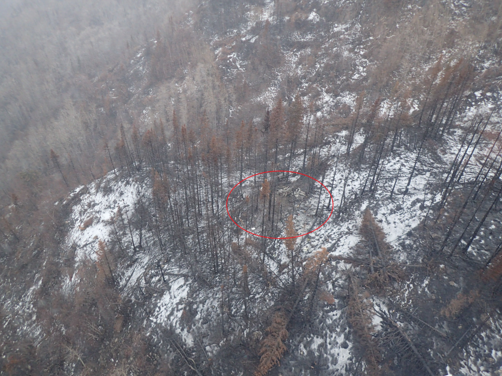
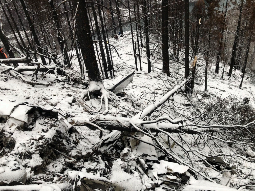
Photos: NTSB
Revision history:
| Date/time | Contributor | Updates |
|---|---|---|
| 30-Nov-2019 20:41 | Captain Adam | Added |
| 30-Nov-2019 21:08 | Geno | Updated [Time, Departure airport, Destination airport, Source] |
| 30-Nov-2019 21:24 | Captain Adam | Updated [Aircraft type, Source] |
| 30-Nov-2019 21:35 | Captain Adam | Updated [Operator, Total occupants, Other fatalities, Source, Narrative] |
| 30-Nov-2019 21:49 | RobertMB | Updated [Date, Source] |
| 01-Dec-2019 22:20 | RobertMB | Updated [Time, Aircraft type, Nature, Source, Narrative] |
| 02-Dec-2019 02:21 | RobertMB | Updated [Total fatalities, Nature, Source, Narrative] |
| 02-Dec-2019 15:19 | Captain Adam | Updated [Registration, Cn, Source, Narrative] |
| 02-Dec-2019 15:28 | RobertMB | Updated [Time, Operator, Source, Narrative] |
| 02-Dec-2019 22:22 | Captain Adam | Updated [Operator, Narrative] |
| 27-Sep-2020 17:01 | Aerossurance | Updated [Source, Narrative] |
| 01-Jun-2022 09:35 | Anon. | Updated [Source] |
Corrections or additions? ... Edit this accident description
The Aviation Safety Network is an exclusive service provided by:
Quick Links:
| ASN Home | Send Correction / Feedback |
| FSF Home | Disclaimer | Copyright |
| Contact Us | Privacy Policy |
| Press / Media |
 ©2024 Flight Safety Foundation