

ASN Wikibase Occurrence # 232794
This information is added by users of ASN. Neither ASN nor the Flight Safety Foundation are responsible for the completeness or correctness of this information.
If you feel this information is incomplete or incorrect, you can submit corrected information.
| Date: | Wednesday 5 February 2020 |
| Time: | 18:07 |
| Type: |  Cessna 140A |
| Owner/operator: | Private |
| Registration: | N9474A |
| MSN: | 15295 |
| Year of manufacture: | 1949 |
| Total airframe hrs: | 8854 hours |
| Engine model: | Continental C-90-12F |
| Fatalities: | Fatalities: 2 / Occupants: 2 |
| Aircraft damage: | Destroyed |
| Category: | Accident |
| Location: | near Columbia Airport (O22), Sonora, CA -
 United States of America United States of America
|
| Phase: | Approach |
| Nature: | Private |
| Departure airport: | Harris Ranch Airport, CA (3O8) |
| Columbia Airport, CA (O22) | |
| Investigating agency: | NTSB |
| Confidence Rating: |
On February 5, 2020, at 1807 Pacific standard time, a Cessna 140A airplane, N9474A, impacted terrain near Sonora, California, while on approach for landing to the Columbia Airport (O22), Columbia California. The private pilot and passenger were fatally injured. The airplane was substantially damaged. The airplane was registered to and operated by the pilot as a Title 14 Code of Federal Regulations Part 91 personal flight. Visual meteorological conditions prevailed and no flight plan had been filed for the cross-country flight. The airplane departed Harris Ranch Airport (3O8), Coalinga, California at 1702.
he pilot performed an uneventful cross-country flight to take the passenger to a business meeting. He intended to complete the trip during the day (and return to the home airport by 1700), so he would not have to fly at night. Radar data indicated the airplane stopped at four airports before departing for the final leg to the home airport. The final stop included fueling the airplane with approximately 20 gallons of 100 low-lead aviation fuel and departing at 1702.
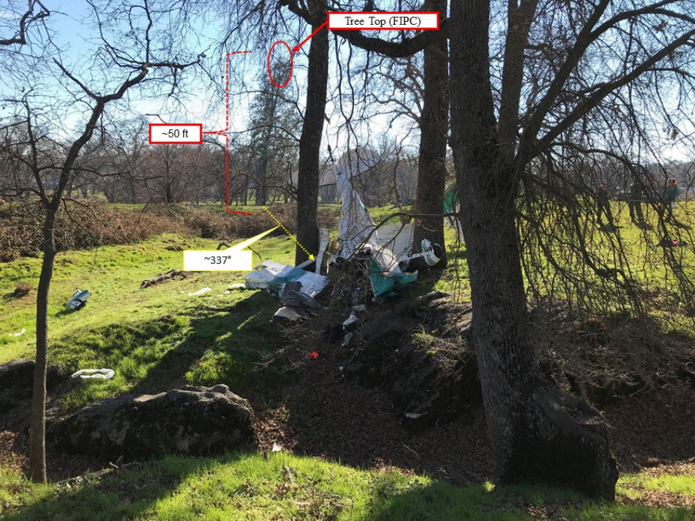
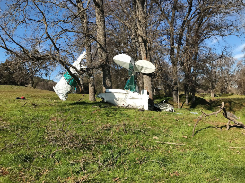
The airplane flew on a northbound heading for about an hour, varying its altitude between 2,000 and 3,000 ft mean sea level (msl) as it continued toward the home airport. When the airplane was about 1.5 nautical miles (nm) from the runway, it turned slightly to the right, consistent with a straight-in approach. It descended gradually until track data were lost about .75 nm from the approach end of the runway. The airplane impacted a tree with its left wing and then continued about 300 ft before coming to rest inverted between two trees.
The accident occurred 39 minutes after sunset and 11 minutes after dusk.
A witness near the accident site reported that he was working on his ranch when the daylight started to fade. He estimated it was around dusk when he heard a loud bang. He looked toward the noise and saw the airplane for about 3 seconds before he heard another bang, followed by silence. Prior to that, he heard the airplane's engine and noted it was not making any unusual sounds.
A postaccident examination of the airframe and engine revealed no evidence of mechanical malfunctions or failures that would have precluded normal operation.
The fact that the pilot did not want to fly at night indicated some apprehension on his part, and his night flying experience could not be determined. It is possible the pilot was distracted by the night conditions and unaware of what the approach to the airport looked like at night. He likely did not see the tree along the flightpath before the airplane’s impact.
Probable Cause: The pilot’s failure to maintain clearance from trees during approach for landing.
Accident investigation:
 |
|
Sources:
https://www.sfchronicle.com/news/article/2-dead-in-plane-crash-in-Sierra-Nevada-foothills-15034063.php
https://sacramento.cbslocal.com/2020/02/05/2-dead-tuolumne-county-plane-crash/
https://www.uniondemocrat.com/image_c75b39e6-4897-11ea-8fbb-97081aeac81a.html
NTSB
https://registry.faa.gov/aircraftinquiry/NNum_Results.aspx?NNumbertxt=9474A
http://www.airport-data.com/images/aircraft/large/000/914/914670.jpg (photo)
History of this aircraft
Other occurrences involving this aircraft
| 3 October 1982 | N9474A | Private | 0 | Wickenburg, AZ | |
sub |
Location
Images:

Photos: NTSB
Revision history:
| Date/time | Contributor | Updates |
|---|---|---|
| 06-Feb-2020 04:49 | Geno | Added |
| 06-Feb-2020 07:00 | gerard57 | Updated [Aircraft type, Source] |
| 06-Feb-2020 07:45 | Geno | Updated [Registration, Cn, Operator, Phase, Departure airport, Source, Damage] |
| 06-Feb-2020 08:16 | RobertMB | Updated [Phase, Nature, Source, Damage, Narrative] |
| 10-Feb-2020 02:43 | Captain Adam | Updated [Location, Phase, Narrative] |
| 11-Feb-2021 15:28 | Anon. | Updated [Phase] |
| 15-Jun-2021 19:16 | aaronwk | Updated [Time, Departure airport, Destination airport, Source, Narrative] |
| 07-Nov-2022 22:18 | Captain Adam | Updated [Location, Phase, Departure airport, Destination airport, Source, Narrative, Accident report, Photo] |
| 07-Nov-2022 22:19 | Captain Adam | Updated [Photo] |
| 07-Nov-2022 22:19 | Captain Adam | Updated [Photo] |
Corrections or additions? ... Edit this accident description
The Aviation Safety Network is an exclusive service provided by:
Quick Links:
| ASN Home | Send Correction / Feedback |
| FSF Home | Disclaimer | Copyright |
| Contact Us | Privacy Policy |
| Press / Media |
 ©2024 Flight Safety Foundation