

ASN Wikibase Occurrence # 244976
This information is added by users of ASN. Neither ASN nor the Flight Safety Foundation are responsible for the completeness or correctness of this information.
If you feel this information is incomplete or incorrect, you can submit corrected information.
| Date: | Monday 16 November 2020 |
| Time: | 06:04 |
| Type: |  Cessna 150L |
| Owner/operator: | Private |
| Registration: | N18666 |
| MSN: | 15074027 |
| Year of manufacture: | 1972 |
| Engine model: | Continental O-200 SERIES |
| Fatalities: | Fatalities: 2 / Occupants: 2 |
| Aircraft damage: | Destroyed |
| Category: | Accident |
| Location: | near Colton, OR -
 United States of America United States of America
|
| Phase: | En route |
| Nature: | Private |
| Departure airport: | Salem-McNary Field, OR (SLE/KSLE) |
| Troutdale Airport, OR (TTD/KTTD) | |
| Investigating agency: | NTSB |
| Confidence Rating: |
On November 16, 2020, about 0604 Pacific standard time, a Cessna 150L, N18666, was destroyed when it was involved in an accident near Colton, Oregon. The pilot and one passenger were fatally injured. The airplane was operated as a Title 14 Code of Federal Regulations Part 91 personal flight.
The instrument-rated pilot departed on an instrument flight rules (IFR) cross-country flight in dark night conditions. While enroute, the pilot cancelled his IFR clearance and reported to the air traffic controller that he was proceeding to another airport. Shortly thereafter, the pilot requested an IFR clearance to the original destination airport, then corrected himself and asked for an IFR clearance to the second airport. Shortly thereafter, the pilot declared an emergency and reported pitot system icing. The controller asked if the pilot could climb and maintain terrain clearance. The pilot replied that he thought he was climbing and asked the controller to verify the airplane’s altitude. However, recorded data showed the airplane in a rapidly steepening descending left turn in the vicinity of the accident site. The wreckage was located the following morning; however, due to the remote location of the site, it was not recovered or examined.
The pilot reported loss of the pitot system due to icing which would have affected the accuracy and response of the airspeed indicator. However, the airplane was flying at altitudes below those forecast to support structural icing. The pilot’s subsequent request to ATC to verify his altitude and statement that he thought he was climbing while data showed the airplane was descending reflects confusion. Several minutes before the pilot’s declaration of emergency the airplane’s track was inconsistent with a direct route or the intended route to the destination airport, showing a series of left and right turns with reversing track changes of about 90 degrees. The distance over which these turns occurred is inconsistent with avoidance of precipitation depicted on a portable display or deviating around clouds to maintain VFR which would have been impossible to do so under dark night conditions over an area of sparse cultural lighting.
The track changes prior to the declaration of emergency, the pilot’s reported confusion about the airplane’s vertical trajectory, and resultant loss of control in a descending turn are consistent with the known effects of spatial disorientation. Because the airplane was not recovered there is insufficient evidence whether this was due to a breakdown in the pilot’s scan under the forecasted turbulent conditions or whether failure of vacuum instruments providing attitude and directional information was involved.
Probable Cause: The pilot’s failure to maintain positive control of the airplane in mountainous terrain during dark night conditions as a result of spatial disorientation which led to a loss of control and subsequent impact with terrain.
Accident investigation:
 |
|
Sources:
https://www.kctv5.com/medical-examiner-ids-father-son-who-died-in-plane-crash-near-estacada/article_3c4156cf-38cc-5a90-bc38-e5e178d232ea.html
https://www.statesmanjournal.com/story/news/2020/11/18/missing-plane-mt-hood-national-forest-search-continues/3773306001/
NTSB
FAA
https://flightaware.com/live/flight/N18666
https://www.airport-data.com/aircraft/photo/000205140.html (photo)
Location
Images:
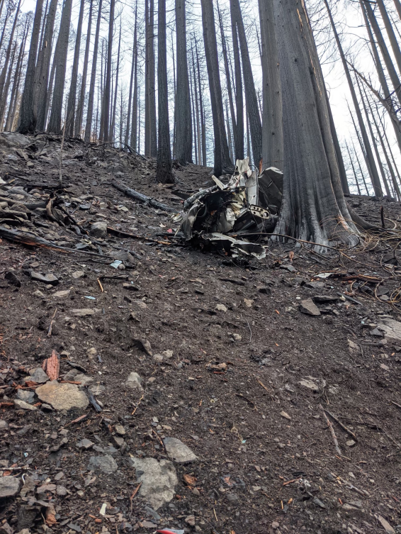
Photo: NTSB
Revision history:
| Date/time | Contributor | Updates |
|---|---|---|
| 17-Nov-2020 20:04 | Captain Adam | Added |
| 19-Nov-2020 07:21 | skygirljenn | Updated [Total fatalities, Total occupants, Source] |
| 21-Nov-2020 02:01 | Geno | Updated [Time, Location, Departure airport, Destination airport, Source, Narrative] |
| 15-Sep-2022 01:31 | Captain Adam | Updated [Time, Location, Source, Damage, Narrative, Category, Accident report, Photo] |
Corrections or additions? ... Edit this accident description
The Aviation Safety Network is an exclusive service provided by:
Quick Links:
| ASN Home | Send Correction / Feedback |
| FSF Home | Disclaimer | Copyright |
| Contact Us | Privacy Policy |
| Press / Media |
 ©2024 Flight Safety Foundation