

ASN Wikibase Occurrence # 247600
This information is added by users of ASN. Neither ASN nor the Flight Safety Foundation are responsible for the completeness or correctness of this information.
If you feel this information is incomplete or incorrect, you can submit corrected information.
| Date: | Sunday 7 February 2021 |
| Time: | 16:47 |
| Type: |  Cessna 441 Conquest II |
| Owner/operator: | BCD Aviation LLC |
| Registration: | N44776 |
| MSN: | 441-0121 |
| Year of manufacture: | 1978 |
| Total airframe hrs: | 9860 hours |
| Engine model: | Airesearch TPE 331-8 |
| Fatalities: | Fatalities: 2 / Occupants: 2 |
| Aircraft damage: | Destroyed |
| Category: | Accident |
| Location: | Belvedere, TN -
 United States of America United States of America
|
| Phase: | Approach |
| Nature: | Private |
| Departure airport: | Thomasville Municipal Airport, GA (TVI/KTVI) |
| Winchester Municipal Airport, TN (KBGF) | |
| Investigating agency: | NTSB |
| Confidence Rating: |
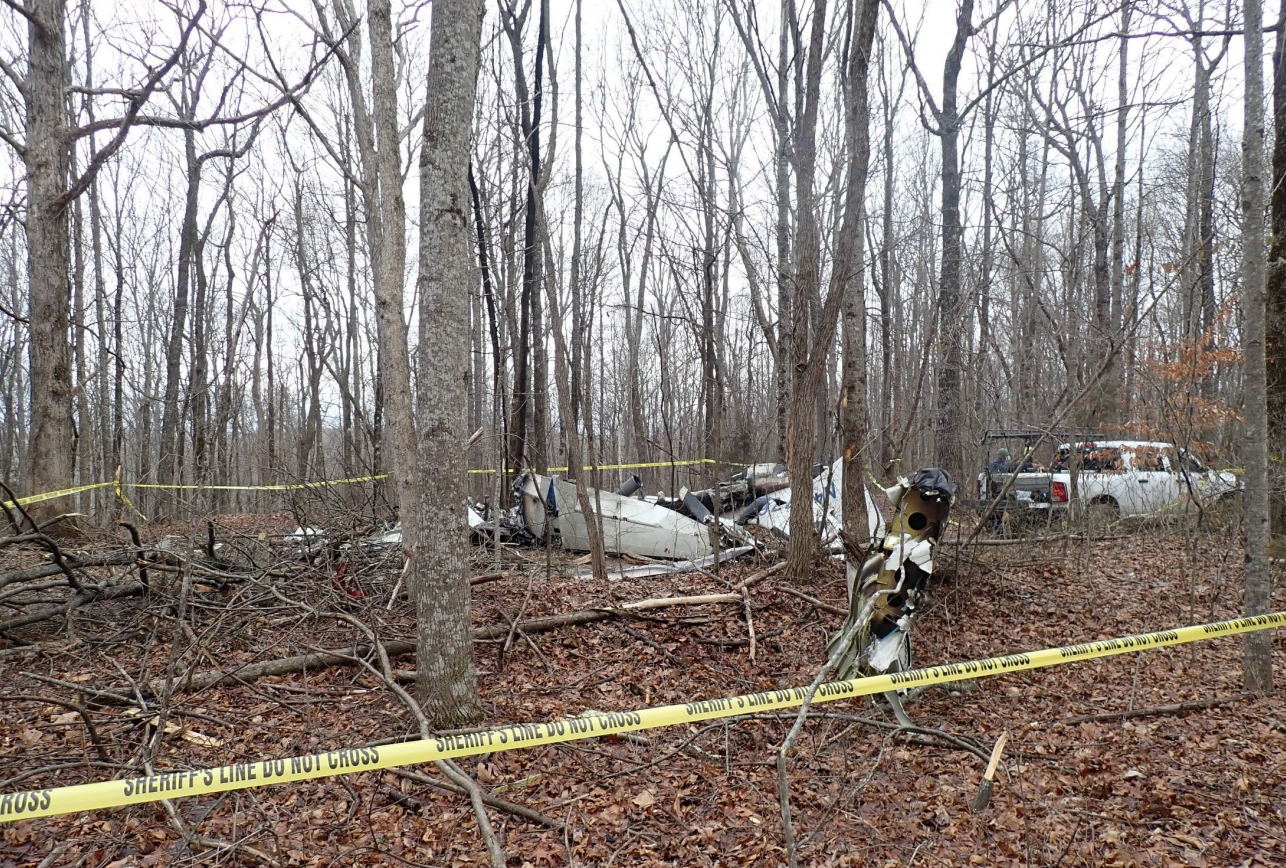
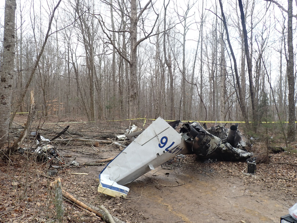
On February 7, 2021, about 1647 central standard time, a Cessna 441, N44776, was destroyed when it was involved in an accident near Belvidere, Tennessee. The airline transport pilot and the commercial pilot-rated passenger were fatally injured. The airplane was operated as a Title 14 Code of Federal Regulations Part 91 personal flight.
The pilot was conducting a cross-country flight and was beginning an instrument flight rules approach from the south. Weather conditions at the destination airport included a ceiling between 800 and 1,000 ft and light rime icing conditions in clouds; the pilot was aware of these conditions. Elevated, wooded terrain existed along the final approach course.
Radar and automatic dependent surveillance-broadcast data revealed that the airplane crossed the intermediate approach fix at the correct altitude; however, the pilot descended the airplane below the final approach fix altitude about 4 miles before the fix. The airplane continued in a gradual descent until radar contact was lost. No distress calls were received from the airplane before the accident. The airplane crashed on a north-northwesterly heading about 5 miles south of the runway threshold. The elevation at the accident site was about 1,880 ft, which was about 900 ft higher than the airport elevation. Postaccident examination of the airframe, engines, and propellers revealed no evidence of a pre-existing mechanical failure or anomaly that would have precluded normal operation.
Because of the weather conditions at the time of the final approach, the pilot likely attempted to fly the airplane under the weather to visually acquire the runway. The terrain along the final approach course would have been obscured in low clouds at the time, resulting in controlled flight into terrain.
Probable Cause: The pilot’s failure to follow the published instrument approach procedure by prematurely descending the airplane below the final approach fix altitude to fly under the low ceiling conditions, which resulted in controlled flight into terrain.
Accident investigation:
 |
|
Sources:
https://fox17.com/news/local/pilot-passenger-killed-in-franklin-county-plane-crash
https://www.tullahomanews.com/news/local/plane-crash-kills-two-in-franklin-county/article_003d0986-6a3b-11eb-944d-eb4c65a7e547.html
NTSB
https://registry.faa.gov/AircraftInquiry/Search/NNumberResult?nNumberTxt=N44776
https://flightaware.com/live/flight/N44776
https://photos-e1.flightcdn.com/photos/retriever/b67e349838ded82fb49710f6f64c2a67d31fdd19 (photo)
Location
Images:
Media:
NTSB is investigating the fatal, Feb. 7, 2021, crash of a Cessna 441 near Belvidere, Tennessee. The NTSB is not traveling to the scene of the accident.
— NTSB_Newsroom (@NTSB_Newsroom) February 8, 2021
Revision history:
| Date/time | Contributor | Updates |
|---|---|---|
| 08-Feb-2021 18:28 | gerard57 | Added |
| 08-Feb-2021 18:57 | Captain Adam | Updated [Aircraft type, Operator, Location, Phase, Nature, Source, Narrative] |
| 08-Feb-2021 19:16 | Geno | Updated [Time, Registration, Cn, Operator, Departure airport, Destination airport, Source] |
| 08-Feb-2021 19:25 | RobertMB | Updated [Time, Aircraft type, Registration, Cn, Operator, Location, Phase, Nature, Source, Narrative] |
| 09-Feb-2021 07:19 | Anon. | Updated [Time, Total fatalities, Total occupants, Source, Narrative] |
| 09-Feb-2021 09:12 | RobertMB | Updated [Time, Total occupants, Source, Narrative] |
| 09-Feb-2021 09:13 | RobertMB | Updated [Total fatalities] |
| 09-Feb-2021 09:13 | RobertMB | Updated [Narrative] |
| 09-Feb-2021 16:26 | RobertMB | Updated [Narrative] |
| 09-Feb-2021 16:30 | RobertMB | Updated [Location, Phase, Source, Narrative] |
| 11-Feb-2021 00:39 | Captain Adam | Updated [Location, Embed code, Narrative] |
| 09-Jul-2021 11:05 | aaronwk | Updated [Time, Location, Phase, Source, Embed code, Narrative, Category] |
| 16-Jun-2023 00:04 | Captain Adam | Updated [[Time, Location, Phase, Source, Embed code, Narrative, Category]] |
Corrections or additions? ... Edit this accident description
The Aviation Safety Network is an exclusive service provided by:
Quick Links:
| ASN Home | Send Correction / Feedback |
| FSF Home | Disclaimer | Copyright |
| Contact Us | Privacy Policy |
| Press / Media |
 ©2024 Flight Safety Foundation