

ASN Wikibase Occurrence # 247848
This information is added by users of ASN. Neither ASN nor the Flight Safety Foundation are responsible for the completeness or correctness of this information.
If you feel this information is incomplete or incorrect, you can submit corrected information.
| Date: | Saturday 13 February 2021 |
| Time: | 16:27 |
| Type: |  Piper PA-46R-350T Matrix |
| Owner/operator: | IST Solutions LLC |
| Registration: | N40TS |
| MSN: | 4692156 |
| Year of manufacture: | 2010 |
| Total airframe hrs: | 877 hours |
| Engine model: | Lycoming TIO-540-AE2A |
| Fatalities: | Fatalities: 1 / Occupants: 1 |
| Aircraft damage: | Destroyed |
| Category: | Accident |
| Location: | near Tehachapi, CA -
 United States of America United States of America
|
| Phase: | En route |
| Nature: | Private |
| Departure airport: | Camarillo Airport, CA (KCMA) |
| Mammoth Lakes Airport, CA (MMH/KMMH) | |
| Investigating agency: | NTSB |
| Confidence Rating: |
On February 13, 2021, about 1627 Pacific standard time, a Piper PA46R-350T airplane, N40TS, was destroyed when it was involved in an accident near Tehachapi, California. The non-instrument-rated pilot was fatally injured. The airplane was operated as a Title 14 Code of Federal Regulations Part 91 personal flight.
The non-instrument-rated pilot departed on a cross-country flight. Radar track data revealed the airplane traveled on a relatively straight course to the northeast for about 32 minutes. Near the end of the flight track data, the track showed an increasingly tight left spiraling turn near the accident site. The airplane impacted steep sloping terrain, and a postimpact fire ensued. As a result of the impact, the airplane was segmented into several sections.
Examination of the wreckage revealed no evidence of mechanical malfunction or failures that would have precluded normal operation. The attitude indicator instrument was disassembled, and the vacuum-powered rotor and housing revealed rotational scoring damage, indicating the instrument vacuum system was operational at the time of the accident.
The investigation found no evidence indicating the pilot checked the weather or received weather information before departure. The surrounding weather reporting stations near the accident site reported wind conditions with peak gusts up to 47 knots around the time of the accident. The pilot likely encountered mountain wave activity with severe turbulence, which resulted in loss of control of the airplane and impact with terrain. Contributing to the accident was the pilot’s failure to obtain a preflight weather briefing, which would have alerted him to the presence of hazardous strong winds and turbulent conditions.
Postmortem toxicology testing of the pilot’s lung and muscle tissue samples detected several substances that are mentally and physically impairing individually and even more so in combination for performing hazardous and complex tasks. However, blood concentrations are needed to determine the level of impairment, and no blood samples for the pilot were available. While the pilot was taking potentially impairing medications and likely had conditions that would influence decision making and reduce performance, without blood concentrations, it was not possible to determine whether the potentially impairing combination of medications degraded his ability to safely operate the airplane.
Probable Cause: The pilot’s encounter with mountain wave activity with severe turbulence, which resulted in a loss of airplane control. Contributing to the accident was the pilot’s failure to obtain a preflight weather briefing.
Accident investigation:
 |
|
Sources:
https://www.kget.com/news/local-news/authorities-search-tehachapi-mountains-for-reported-missing-aircraft/
NTSB
https://registry.faa.gov/aircraftinquiry/Search/NNumberResult
https://flightaware.com/live/flight/N40TS/history/20210214/0018Z/KCMA/L%2035.01389%20-118.38811
https://globe.adsbexchange.com/?icao=a4ac02&lat=35.013&lon=-118.389&zoom=16.5&showTrace=2021-02-14
Location
Images:
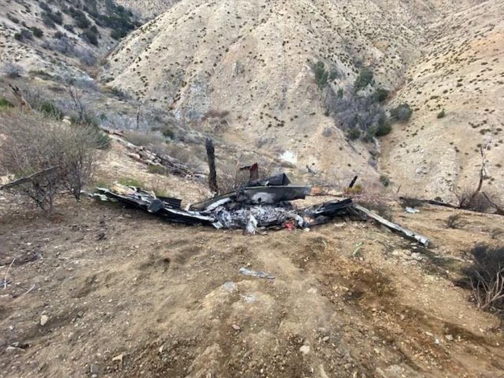
Photo: NTSB
Revision history:
| Date/time | Contributor | Updates |
|---|---|---|
| 15-Feb-2021 16:56 | Geno | Added |
| 15-Feb-2021 18:43 | Geno | Updated [Aircraft type, Total fatalities, Other fatalities, Narrative] |
| 15-Feb-2021 19:04 | Anon. | Updated [Source, Damage, Narrative] |
| 16-Feb-2021 19:31 | Anon. | Updated [Narrative] |
| 08-Apr-2021 09:33 | Trislander | Updated [Destination airport] |
| 10-Jul-2021 08:40 | aaronwk | Updated [Time, Source, Narrative, Category] |
Corrections or additions? ... Edit this accident description
The Aviation Safety Network is an exclusive service provided by:
Quick Links:
| ASN Home | Send Correction / Feedback |
| FSF Home | Disclaimer | Copyright |
| Contact Us | Privacy Policy |
| Press / Media |
 ©2024 Flight Safety Foundation