

ASN Wikibase Occurrence # 248597
This information is added by users of ASN. Neither ASN nor the Flight Safety Foundation are responsible for the completeness or correctness of this information.
If you feel this information is incomplete or incorrect, you can submit corrected information.
| Date: | Saturday 6 March 2021 |
| Time: | 06:10 |
| Type: |  Aviat A-1B Husky |
| Owner/operator: | Private |
| Registration: | N166WW |
| MSN: | 2372 |
| Year of manufacture: | 2006 |
| Engine model: | Lycoming IO-360-A1D6 |
| Fatalities: | Fatalities: 1 / Occupants: 1 |
| Aircraft damage: | Destroyed |
| Category: | Accident |
| Location: | near Berwyn, NE -
 United States of America United States of America
|
| Phase: | En route |
| Nature: | Private |
| Departure airport: | Mason City Airport, NE (KPVT) |
| Holyoke Airport, CO (KHEQ) | |
| Investigating agency: | NTSB |
| Confidence Rating: |
On March 6, 2021, about 0610 central standard time, an Aviat A-1B airplane, N166WW, was destroyed when it was involved in an accident near Berwyn, Nebraska. The pilot was fatally injured. The airplane was operated as a Title 14 Code of Federal Regulations (CFR) Part 91 personal flight.
Primary radar first picked up the airplane about 0555, 1/2 mile south of the private runway. The airplane track proceeded generally west-southwest for about 11 miles when it made a left turn toward the south at a speed of about 88 knots. The track then made right 360-degree turn; during which, the speed of the airplane increased to about 114 knots. Followed by a tighter 360-degree turn at 49 knots and decreasing. The track then zig zagged at an average of 30 knots until 0609 when the track terminated about 1,000 ft from the accident site.
The airplane impacted a field perpendicular to a gully in a very rural area; the debris field was about 300 ft long. The first identified point of impact was a long narrow area of disturbed dirt with the right wingtip nearby. Next were two slash marks consistent with propeller blade slices; followed by a large area of disturbed dirt with propeller blade fragments. The main wreckage came to rest at the bottom of the gully; the last major piece of debris was the engine. Postaccident examination of the airframe and engine did not reveal any anomalies that would have precluded normal operations.
The pilot flew the accident airplane regularly over his land and pastures. It was not abnormal for him to takeoff before sunrise despite not holding an instrument rating. At the time of the accident the moon was 22.97 degrees above the horizon at third quarter phase. Its illumination was 45.1% of the moon’s full potential. There were no high-altitude cloud layers to block the moonlight. Therefore, it was dark with the exception of any ground lights and moon illumination.
The flight track immediately before the accident was consistent with a pilot experiencing spatial disorientation and subsequently losing airplane control. Several factors support this conclusion, which include the low moonlight; few ground lights in a rural area; the pilot’s lack of instrument rating; and the airplane’s abrupt roll, heading, and speed changes leading up to the accident site.
Probable Cause: A loss of control and subsequent impact with terrain as a result of spatial disorientation during cruise in dark night conditions.
Accident investigation:
 |
|
Sources:
https://rivercountry.newschannelnebraska.com/story/43457144/fatality-reported-after-plane-crash-near-ansley
https://registry.faa.gov/AircraftInquiry/Search/NNumberResult?nNumberTxt=N166W
NTSB
https://cdn.jetphotos.com/full/2/65893_1164301554.jpg (photo)
Location
Images:
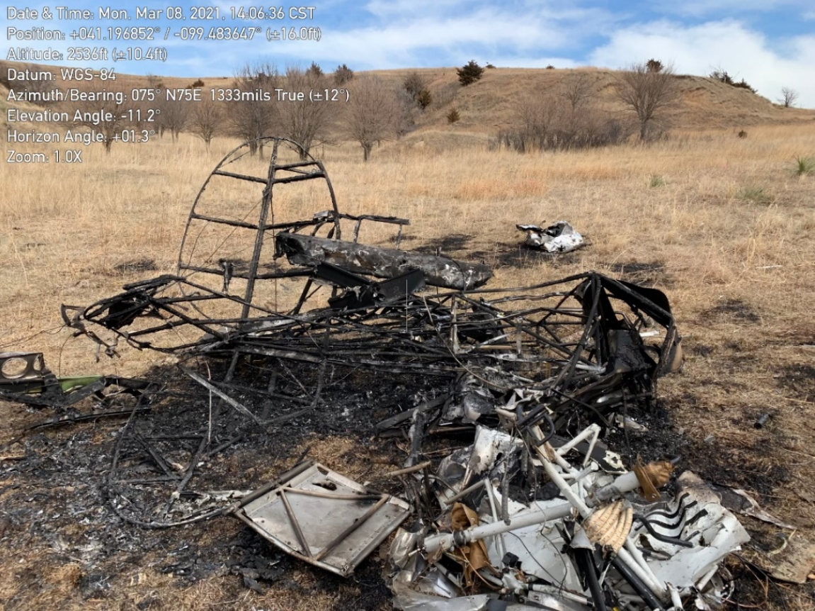
Photo: NTSB
Media:
NTSB is investigating the March 6, 2021, crash of an Aviat A1B Husky airplane near Berwyn, Nebraska. The NTSB is not traveling to the scene.
— NTSB_Newsroom (@NTSB_Newsroom) March 7, 2021
Revision history:
| Date/time | Contributor | Updates |
|---|---|---|
| 07-Mar-2021 02:42 | Captain Adam | Added |
| 07-Mar-2021 11:18 | Captain Adam | Updated [Total fatalities, Total occupants, Other fatalities, Location, Source, Embed code, Narrative] |
| 08-Mar-2021 16:16 | RobertMB | Updated [Time, Registration, Cn, Operator, Phase, Nature, Source, Narrative] |
| 08-Mar-2021 18:13 | Anon. | Updated [Source] |
| 20-Jul-2022 02:32 | Captain Adam | Updated [Time, Location, Departure airport, Destination airport, Source, Damage, Narrative, Category, Accident report, Photo] |
Corrections or additions? ... Edit this accident description
The Aviation Safety Network is an exclusive service provided by:
Quick Links:
| ASN Home | Send Correction / Feedback |
| FSF Home | Disclaimer | Copyright |
| Contact Us | Privacy Policy |
| Press / Media |
 ©2024 Flight Safety Foundation