

ASN Wikibase Occurrence # 248676
This information is added by users of ASN. Neither ASN nor the Flight Safety Foundation are responsible for the completeness or correctness of this information.
If you feel this information is incomplete or incorrect, you can submit corrected information.
| Date: | Wednesday 10 February 2016 |
| Time: | 20:18 LT |
| Type: |  Boeing 737-3Q8 |
| Owner/operator: | Peruvian Airlines |
| Registration: | OB-2037-P |
| MSN: | 26296/2581 |
| Year of manufacture: | 1994 |
| Fatalities: | Fatalities: 0 / Occupants: 128 |
| Aircraft damage: | Minor |
| Category: | Serious incident |
| Location: | Iquitos-Coronel FAP Francisco Secada Vignetta International Airport (I -
 Peru Peru
|
| Phase: | Landing |
| Nature: | Passenger - Scheduled |
| Departure airport: | Lima-Jorge Chávez International Airport (LIM/SPJC) |
| Iquitos International Airport (IQT/SPQT) | |
| Investigating agency: | CIAA |
| Confidence Rating: |
Peruvian Airlines flight PVN122, a Boeing 737-3Q8, veered off the side of the runway after landing at Iquitos Airport, Peru. The aircraft was operating a passenger service from Lima, Peru.
After starting the descent to Iquitos, the crew requested updated information on the weather conditions, being informed by ATC that a convective system (CB) was approaching from the north-east to the airport area. Winds were 110° at 12 to a maximum of 21 knots. ATC instructed the crew to maintain a high speed on the approach and to report at reporting point PANTA before starting an ILS approach to runway 06.
At 20:07 Iquitos ATC reported a Special Metar (SPECI), reporting visibility of more than 8 kilometers, with broken cloud cover at 1500 feet, and a convective system (CB) at 2500 feet, broken cloud cover at 10000 feet, rain over the station and wet runway with wind from 110° at 13 to a maximum of 21 knots. ATC cleared the flight to continue with the ILS approach to runway 06.
Before landing, ATC indicated a wind of 130° at 11 - 16 knots.
During the final approach the aircrart gradually drifted to the left of the runway center line. On short final the flight crew began to crab the plane until an altitude of about 50 feet when the aircraft was decrabbed again to align it with the runway. The aircraft then touched down 22,55 meters to the left of the runway centreline. At a distance of 358 meters from the threshold, the aircraft veered off the left side of the runway, damaging several runway lights. The aircraft rolled parallel to the runway with the three gears on muddy and rocky terrain, until the flight crew was able to steer the aircraft back onto the runway. The aircraft had covered a distance of approximately 518 meters outside the runway.
The reversers of both engines were not used, probably because the no.2 engine reverser was inoperative. After re-entering the runway at 990 meters with a speed of 60 knots, the aircraft taxied to the parking apron.
The aircraft had sustained damage to the main gears, the air intakes of both engines, and the lower fuselage.
PROBABLE CAUSE:
Loss of situational awareness of the flight crew during landing, who did not realize that the aircraft destabilized during the high reset, moving laterally to the left due to the effect of the weather conditions of strong wind, rain and reduced visibility, generating a runway departure (Runway Excursion).
CONTRIBUTING FACTORS
1 The presence of a storm system over the airport significantly increased the operational load of the flight crew, the action of crosswinds, turbulence and heavy rain affected the stability of the approach, a condition that the crew should have analyzed to make the decision to perform a Go Around.
2 The airport infrastructure is a factor related to the aircraft's runway excursion, since the main runway does not have a runway axis light system.
Accident investigation:
 |
|
Sources:
CIAA
Images:
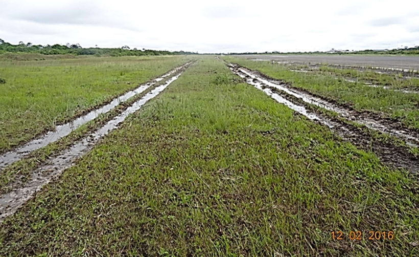
Photo: CIAA
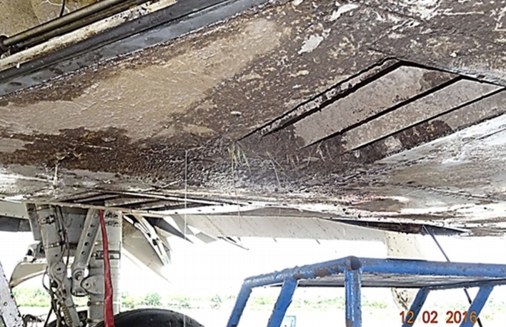
Photo: CIAA
Revision history:
| Date/time | Contributor | Updates |
|---|---|---|
| 09-Mar-2021 20:06 | harro | Added |
| 09-Mar-2021 20:20 | harro | Updated [Location, Departure airport, Destination airport, Narrative, Photo] |
| 09-Mar-2021 20:39 | harro | Updated [Category, Photo] |
Corrections or additions? ... Edit this accident description
The Aviation Safety Network is an exclusive service provided by:
Quick Links:
| ASN Home | Send Correction / Feedback |
| FSF Home | Disclaimer | Copyright |
| Contact Us | Privacy Policy |
| Press / Media |
 ©2024 Flight Safety Foundation