

ASN Wikibase Occurrence # 248701
This information is added by users of ASN. Neither ASN nor the Flight Safety Foundation are responsible for the completeness or correctness of this information.
If you feel this information is incomplete or incorrect, you can submit corrected information.
| Date: | Tuesday 9 March 2021 |
| Time: | 12:15 |
| Type: |  Cessna 170A |
| Owner/operator: | Private |
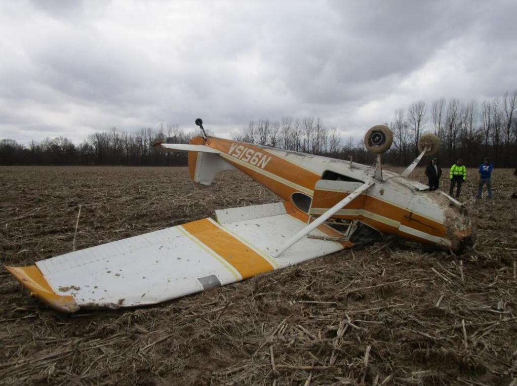
| Registration: | N9515A |
| MSN: | 19383 |
| Year of manufacture: | 1950 |
| Total airframe hrs: | 2717 hours |
| Engine model: | Continental O-300-A |
| Fatalities: | Fatalities: 0 / Occupants: 1 |
| Aircraft damage: | Substantial |
| Category: | Accident |
| Location: | near Poplar Bluff, MO -
 United States of America United States of America
|
| Phase: | Landing |
| Nature: | Private |
| Departure airport: | Shawnee Municipal Airport, OK (SNL/KSNL) |
| Poplar Bluff Regional Business Airport, MO (KPOF) | |
| Investigating agency: | NTSB |
| Confidence Rating: |
On March 9, 2021, about 1215 central standard time, a Cessna 170A, N9515A, was substantially damaged when it was involved in an accident near Poplar Bluff, Missouri. The pilot was not injured. The airplane was operated as a Title 14 Code of Federal Regulations Part 91 personal flight.
The pilot was conducting a cross-country flight and became lost as he neared his intended destination. During the flight, the pilot navigated via dead-reckoning and following roads. He occasionally referenced a mobile phone application to verify the airplane’s position on a digitized visual flight rules (VFR) sectional chart. The pilot did not have traditional paper VFR sectional charts to navigate with, if his mobile phone’s battery became depleted during the flight. Although he had access to a handheld GPS device, he did not use the device to navigate during the flight.
About 15-20 minutes before reaching the intended destination, the pilot’s mobile phone powered off after its battery became depleted. The pilot then inserted the GPS power adapter into the airplane’s cigarette-lighter socket, but the GPS device did not power-on. The pilot continued on the current heading that took the airplane over his intended destination, but he could not locate the airport and subsequently decided to make an off-airport precautionary landing before the airplane ran out of fuel.
The pilot landed the airplane in what he believed to be a suitable field; however, after touchdown, the airplane’s main landing gear dug into soft terrain and the airplane nosed over. The airplane sustained substantial damage to the vertical stabilizer and the engine mounts.
Postaccident examination and testing did not reveal any electrical system anomalies that would have prevented the pilot from using the airplane’s cigarette-lighter socket as a power source for his mobile phone and handheld GPS during the flight. Additional bench testing of the alternator, voltage regulator, and battery did not reveal any anomalies that would have prevented normal operation of the airplane’s electrical charging system.
Probable Cause: The pilot’s decision to make a precautionary landing in a field that contained soft terrain, which resulted in the airplane nosing over. Contributing to the accident was the pilot’s decision to fly without a printed VFR sectional chart to identify the location of the destination airport.
Accident investigation:
 |
|
Sources:
https://www.darnews.com/story/2870436.html
NTSB
https://registry.faa.gov/aircraftinquiry/Search/NNumberResult?nNumberTxt=9515A
https://www.airport-data.com/images/aircraft/000/006/006527.jpg (photo)
Location
Images:
Revision history:
| Date/time | Contributor | Updates |
|---|---|---|
| 10-Mar-2021 18:36 | Geno | Added |
| 10-Mar-2021 20:12 | RobertMB | Updated [Time, Aircraft type, Location, Source, Damage, Narrative] |
Corrections or additions? ... Edit this accident description
The Aviation Safety Network is an exclusive service provided by:
Quick Links:
| ASN Home | Send Correction / Feedback |
| FSF Home | Disclaimer | Copyright |
| Contact Us | Privacy Policy |
| Press / Media |
 ©2024 Flight Safety Foundation