

ASN Wikibase Occurrence # 24890
This information is added by users of ASN. Neither ASN nor the Flight Safety Foundation are responsible for the completeness or correctness of this information.
If you feel this information is incomplete or incorrect, you can submit corrected information.
| Date: | Tuesday 7 July 1998 |
| Time: | 15:47 |
| Type: |  Swearingen SA.26AT Merlin IIB |
| Owner/operator: | F.S. Air Service Inc |
| Registration: | N501FS |
| MSN: | T26-146 |
| Year of manufacture: | 1969 |
| Total airframe hrs: | 7799 hours |
| Engine model: | Garrett TP-331-1-151G |
| Fatalities: | Fatalities: 2 / Occupants: 2 |
| Aircraft damage: | Destroyed |
| Category: | Accident |
| Location: | Saint George, AK -
 United States of America United States of America
|
| Phase: | Approach |
| Nature: | Ferry/positioning |
| Departure airport: | Anchorage International Airport, AK (ANC/PANC) |
| St. George Airport, AK (PBV) | |
| Investigating agency: | NTSB |
| Confidence Rating: |
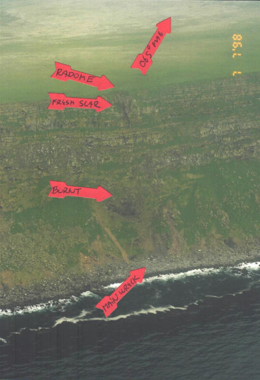
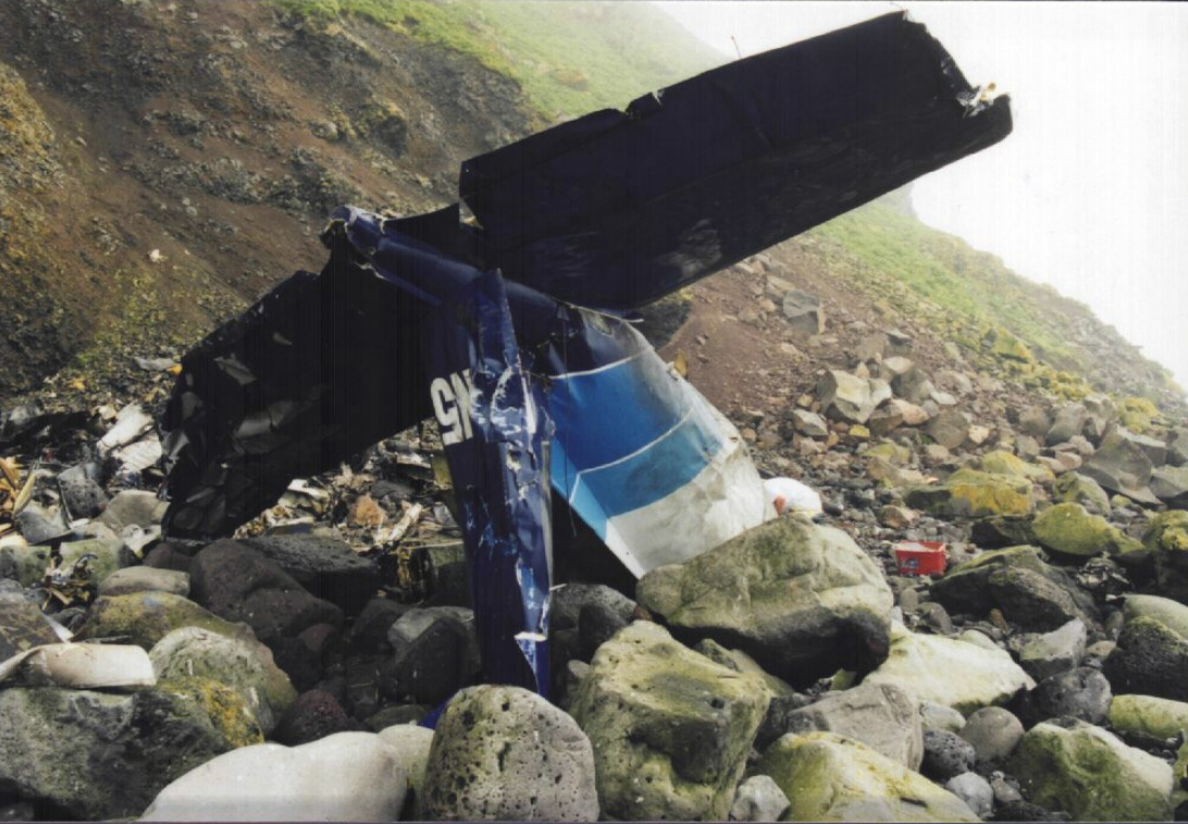
On July 7, 1998, about 1547 Alaska daylight time, a Swearingen SA-26AT Merlin-IIB airplane, N501FS, operated by F. S. Air Service, Inc., of Anchorage, Alaska, was destroyed when it impacted terrain about 5.5 miles west-northwest of the New Saint George Airport, Saint George, Alaska. The two occupants, both flight crewmembers, sustained fatal injuries. The pilot-in-command (PIC) was the president and owner of F. S. Air Service, Inc., and occupied the right pilot seat. The copilot was not qualified as a pilot-in-command of the SA-26AT, and occupied the left pilot seat. The flight was conducted under 14 CFR Part 91 as a positioning flight to pick up three passengers for an on-demand charter flight from Saint George. The flight departed Anchorage International Airport at 1240 under a VFR flight plan, and an IFR clearance was received approximately 100 nautical miles northeast of Saint George. Instrument meteorological conditions prevailed at Saint George at the time of the accident.
The flight departed Anchorage, Alaska, and was en route to Saint George, Alaska, to pick up passengers for a return flight to Anchorage. The pilot-in-command (PIC) was seated in the right seat, and the copilot was seated in the left seat. This was the copilot's third flight in this make and model airplane, and he was not qualified as a crewman in it under 14 CFR Part 135. There was no record of when the copilot last performed a nondirectional beacon (NDB) approach. The NDB indicator in the cockpit was on the left side of the left control column, partially blocked from the view of the PIC. The minimum altitude for the segment of the approach prior to the final approach fix (FAF) was 1,700 feet. The Minimum Descent Altitude (MDA) for the final segment of the approach was 880 feet. The reported ceiling was 100 feet overcast. The Air Route Traffic Control Center radar altitude readout for the airplane revealed that the airplane descended below 600 feet prior to reaching the FAF. The radar ground track revealed the airplane on course prior to the course reversal procedure turn on the published approach. The radar ground track showed that after the course reversal, the airplane continued through the published final approach course, and turned to parallel the inbound track three miles north of course. The radar plot terminates about the location of the 550 feet high cliffs where the airplane was located. Weather at the time of the accident was reported as 100 foot overcast. This location was 5.5 miles (DME) from the airport. A review of radar tapes from the day prior to the accident, show the same airplane and PIC tracking the published course outbound and inbound, and descending below the published approach minima to below 500 feet. This flight successfully landed at the airport. An interview with the copilot from the successful flight revealed that the PIC intentionally descended to 300 feet on the approach until he acquired visual contact with the ocean, then flew to the airport to land. An aircraft flying on the published inbound final approach course at 5.5 DME is over water, approximately three miles from the nearest terrain.
Probable Cause: The pilot-in-command's failure to adequately monitor the instrument approach and the co-pilot's failure to intercept and maintain the proper NDB bearing on the approach. Contributing factors were the pilot-in-command's obstructed view of the NDB indicator and his overconfidence in his personal ability, the terrain (cliffs), low ceiling, and the flight crew's disregard of the minimum descent altitude.
Accident investigation:
 |
|
Sources:
NTSB
History of this aircraft
Other occurrences involving this aircraft
| 5 June 1996 | N501FS | Fs Air | 0 | Galena, AK | |
sub |
Images:
Photos: NTSB
Revision history:
| Date/time | Contributor | Updates |
|---|---|---|
| 27-Sep-2008 01:00 | ASN archive | Added |
| 16-Oct-2010 11:19 | TB | Updated [Time, Aircraft type, Other fatalities, Location, Phase, Nature, Departure airport, Destination airport, Source, Damage, Narrative] |
| 21-Dec-2016 19:14 | ASN Update Bot | Updated [Time, Damage, Category, Investigating agency] |
| 21-Dec-2016 19:16 | ASN Update Bot | Updated [Time, Damage, Category, Investigating agency] |
| 21-Dec-2016 19:20 | ASN Update Bot | Updated [Time, Damage, Category, Investigating agency] |
| 13-Oct-2022 11:29 | Captain Adam | Updated [Operator, Departure airport, Destination airport, Narrative, Accident report, Photo] |
| 13-Oct-2022 11:30 | Captain Adam | Updated [Photo] |
Corrections or additions? ... Edit this accident description
The Aviation Safety Network is an exclusive service provided by:
Quick Links:
| ASN Home | Send Correction / Feedback |
| FSF Home | Disclaimer | Copyright |
| Contact Us | Privacy Policy |
| Press / Media |
 ©2024 Flight Safety Foundation