

ASN Wikibase Occurrence # 25998
This information is added by users of ASN. Neither ASN nor the Flight Safety Foundation are responsible for the completeness or correctness of this information.
If you feel this information is incomplete or incorrect, you can submit corrected information.
| Date: | Sunday 17 March 2002 |
| Time: | 23:06 |
| Type: |  Piper PA-31P Pressurized Navajo |
| Owner/operator: | Floopie Flight Corp. |
| Registration: | N125TT |
| MSN: | 31P-7400187 |
| Year of manufacture: | 1974 |
| Total airframe hrs: | 3991 hours |
| Engine model: | Lycoming TIGO-541E1A |
| Fatalities: | Fatalities: 2 / Occupants: 2 |
| Aircraft damage: | Destroyed |
| Category: | Accident |
| Location: | Daleville, 3.7 miles from Anderson, Indiana -
 United States of America United States of America
|
| Phase: | Approach |
| Nature: | Private |
| Departure airport: | LA GRANGE, GA (LGC) |
| Anderson, IN (AID) | |
| Investigating agency: | NTSB |
| Confidence Rating: |
The airplane was destroyed by impact forces and fire, when it impacted the ground about 3.7 miles from the destination airport. The airplane had been cleared for an ILS approach to the airport. No anomalies were found during the on-scene examination of the airframe, engine or gyroscopic flight instruments that could be associated with a pre-existing condition. The minimum descent altitude for the approach is 243 feet above ground level. The inbound course for the instrument approach is 298 degrees magnetic. The radar data shows that the airplane headed in a northerly direction prior to commencing a left turn onto the inbound course of the instrument approach. The last radar return, was received prior to the airplane reaching the locator outer marker for the approach. Altitude returns show the airplane descending from a pressure altitude of 4,000 feet to a pressure altitude of 2,800 feet. The 2,800-foot return was the final return received. The wreckage path was distributed on a magnetic heading of approximately 145 degrees. The weather reporting station located at the destination airport recorded a 100 foot overcast ceiling with 1 statute mile of visibility about 20 minutes prior to the accident. The current weather was available to the pilot via the Automated Weather Observing System at the destination airport. No communications were received from the airplane after controllers authorized the pilot to change to the destination airport's advisory frequency.
Probable Cause: The pilots failure to maintain control of the airplane during the instrument approach. The low overcast ceiling and the pilot's in-flight decision to execute the instrument approach in below minimum weather conditions were factors.
Sources:
NTSB: https://www.ntsb.gov/_layouts/ntsb.aviation/brief.aspx?ev_id=20020326X00402&key=1
FAA register: 2. FAA: http://registry.faa.gov/aircraftinquiry/NNum_Results.aspx?NNumbertxt=125TT
Location
Images:
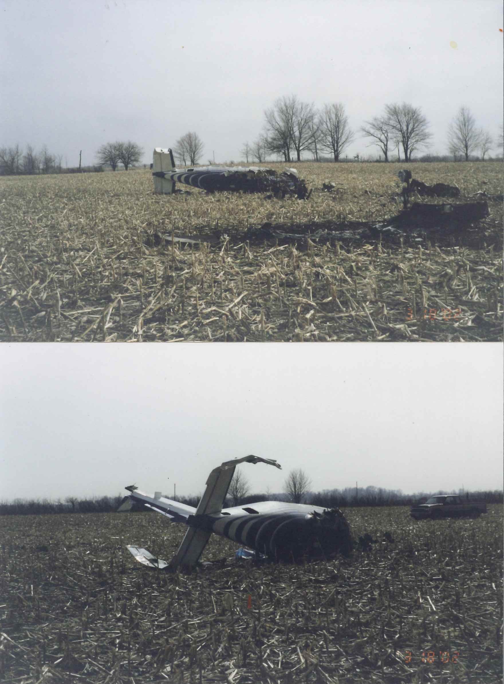
Taken March 18, 2002 at crash site
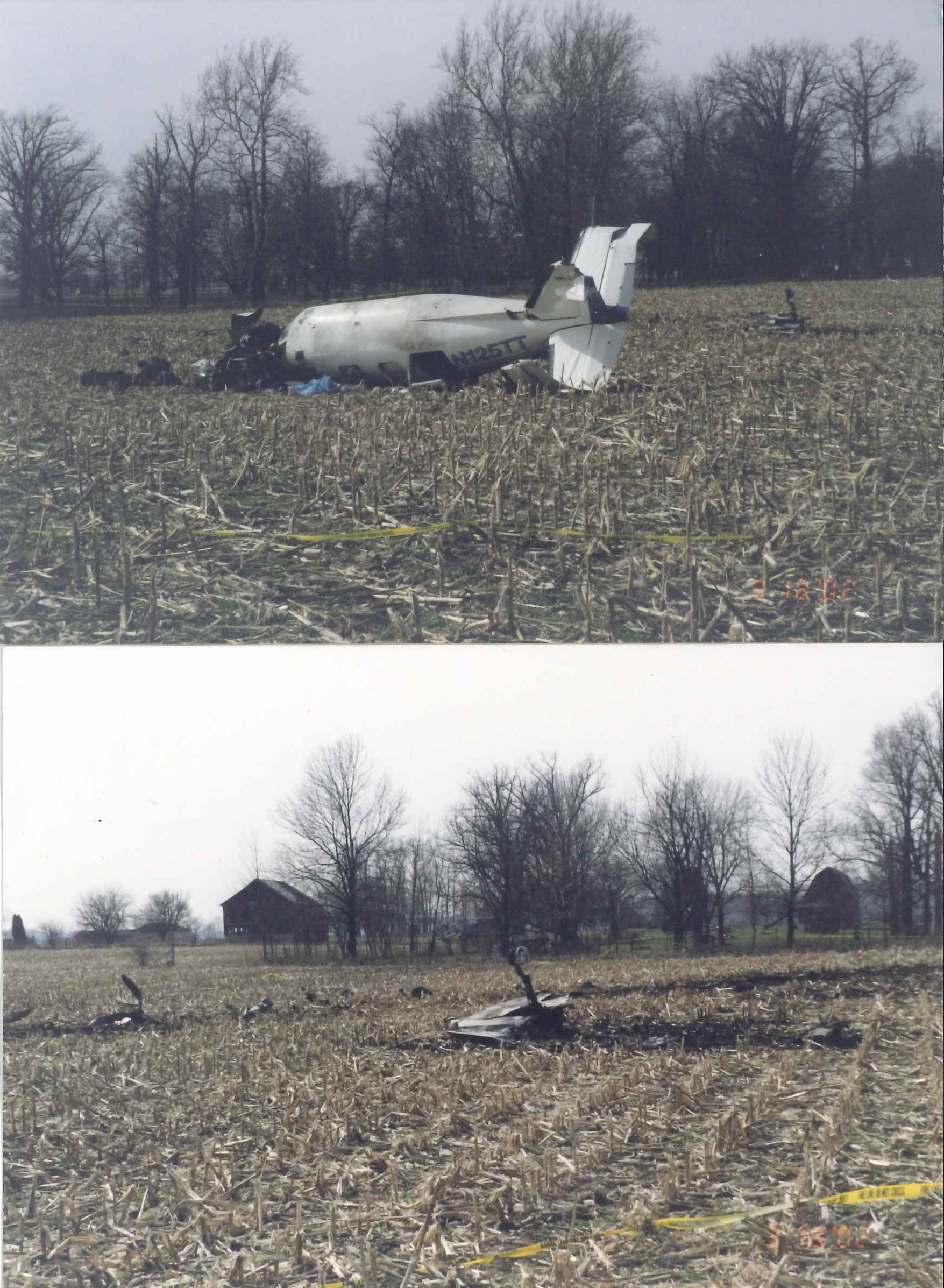
Taken March 18, 2002 at crash site
Revision history:
| Date/time | Contributor | Updates |
|---|---|---|
| 27-Sep-2008 01:00 | ASN archive | Added |
| 04-Jun-2015 05:17 | Dr. John Smith | Updated [Time, Cn, Location, Phase, Nature, Departure airport, Destination airport, Source, Damage, Narrative] |
| 28-Jun-2015 18:52 | Dr. John Smith | Updated [Source, Narrative] |
| 21-Dec-2016 19:14 | ASN Update Bot | Updated [Time, Damage, Category, Investigating agency] |
| 21-Dec-2016 19:16 | ASN Update Bot | Updated [Time, Damage, Category, Investigating agency] |
| 21-Dec-2016 19:20 | ASN Update Bot | Updated [Time, Damage, Category, Investigating agency] |
| 17-Oct-2017 12:37 | Dr. John Smith | Updated [Time, Operator, Source, Narrative] |
| 09-Dec-2017 15:52 | ASN Update Bot | Updated [Time, Operator, Nature, Departure airport, Destination airport, Source, Narrative] |
| 19-Aug-2020 11:31 | brian_a_mcmillen | Updated [Source, Photo] |
| 19-Aug-2020 11:31 | brian_a_mcmillen | Updated [Source, Photo] |
Corrections or additions? ... Edit this accident description
The Aviation Safety Network is an exclusive service provided by:
Quick Links:
| ASN Home | Send Correction / Feedback |
| FSF Home | Disclaimer | Copyright |
| Contact Us | Privacy Policy |
| Press / Media |
 ©2024 Flight Safety Foundation