

ASN Wikibase Occurrence # 265408
This information is added by users of ASN. Neither ASN nor the Flight Safety Foundation are responsible for the completeness or correctness of this information.
If you feel this information is incomplete or incorrect, you can submit corrected information.
| Date: | Tuesday 13 July 2021 |
| Time: | 10:42 |
| Type: |  Cessna 421C Golden Eagle III |
| Owner/operator: | M E Mullaly Inc |
| Registration: | N678SW |
| MSN: | 421C1023 |
| Total airframe hrs: | 5818 hours |
| Engine model: | Continental GTSIO-520-N ( |
| Fatalities: | Fatalities: 2 / Occupants: 2 |
| Aircraft damage: | Destroyed |
| Category: | Accident |
| Location: | near Monterey Regional Airport (MRY/KMRY), CA -
 United States of America United States of America
|
| Phase: | Initial climb |
| Nature: | Private |
| Departure airport: | Monterey Regional Airport, CA (MRY/KMRY) |
| Sacramento-Mather Airport, CA (MHR/KMHR) | |
| Investigating agency: | NTSB |
| Confidence Rating: |
On July 13, 2021, about 1042 Pacific daylight time (PDT), a Cessna 421C, N678SW, was destroyed when it was involved in an accident near Monterey, California. The pilot and passenger were fatally injured. The airplane was operated as a Title 14 Code of Federal Regulations Part 91 personal flight.
Before taking off, the pilot canceled an instrument flight rules (IFR) flight plan that she had filed and requested a visual flight rules (VFR) on-top clearance, which the controller issued via the Monterey Five departure procedure. The departure procedure included a left turn after takeoff. The pilot took off and climbed to about 818 ft then entered a right turn. The air traffic controller noticed that the airplane was in a right-hand turn rather than a left-hand turn and issued a heading correction to continue a right-hand turn to 030o, which the pilot acknowledged.
The airplane continued the climbing turn for another 925 ft then entered a descent. The controller issued two low altitude alerts with no response from the pilot. No further radio communication with the pilot was received. The airplane continued the descent until it contacted trees, terrain, and a residence about 1 mile from the departure airport.
Review of weather information indicated prevailing instrument meteorological conditions (IMC) in the area due to a low ceiling, with ceilings near 800 ft above ground level and tops near 2,000 ft msl. Examination of the airframe and engines did not reveal any anomalies that would have precluded normal operation.
The airplane’s climbing right turn occurred shortly after the airplane entered IMC while the pilot was acknowledging a frequency change, contacting the next controller, and acknowledging the heading instruction. Track data show that as the right-hand turn continued, the airplane began descending, which was not consistent with its clearance.
Review of the pilot’s logbook showed that the pilot had not met the instrument currency requirements and was likely not proficient at controlling the airplane on instruments. The pilot’s lack of recent experience operating in IMC combined with a momentary diversion of attention to manage the radio may have contributed to the development of spatial disorientation, resulting in a loss of airplane control.
Probable Cause: The pilot’s failure to maintain airplane control due to spatial disorientation during an instrument departure procedure in instrument meteorological conditions which resulted in a collision with terrain. Contributing to the accident was the pilot’s lack of recent instrument flying experience.
Accident investigation:
 |
|
Sources:
https://www.latimes.com/california/story/2021-07-13/small-plane-crashes-into-home-near-monterey-airport
https://www.montereyherald.com/2021/07/14/mch-l-crash-0715/
https://abc7news.com/monterey-plane-crash-fire-monterra-into-home/10884736/
https://www.montereycountyweekly.com/blogs/news_blog/small-plane-crashes-into-a-home-outside-monterey-regional-airport-off-of-highway-68/article_f43b61fe-e407-11eb-b9b9-03c242bf4f6b.html?fbclid=IwAR2-SCCBdEZr4Z2RTwx77JKyrpW4rvj43Fr4u7XWg1g8Ewj8XqBBoDsKBbA
NTSB
https://flightaware.com/live/flight/N678SW/history/20210713/1715Z/KMRY/KSNS
https://globe.adsbexchange.com/?icao=a8fb15&lat=36.568&lon=-121.844&zoom=14.3&showTrace=2021-07-13
https://www.airport-data.com/images/aircraft/001/127/001127128.jpg (photo)
Location
Images:
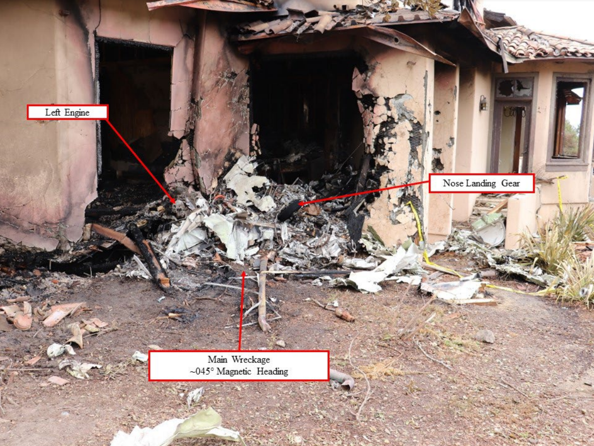
Photo: NTSB
Revision history:
| Date/time | Contributor | Updates |
|---|---|---|
| 13-Jul-2021 20:27 | Captain Adam | Added |
| 13-Jul-2021 23:54 | Geno | Updated [Source] |
| 13-Jul-2021 23:55 | RobertMB | Updated [Time, Aircraft type, Total fatalities, Total occupants, Other fatalities, Nature, Source, Narrative] |
| 13-Jul-2021 23:58 | Geno | Updated [Source] |
| 14-Jul-2021 05:41 | RobertMB | Updated [Location, Narrative] |
| 14-Jul-2021 10:05 | Iceman 29 | Updated [Embed code] |
| 14-Jul-2021 15:33 | Anon. | Updated [Source, Embed code, Narrative] |
| 14-Jul-2021 15:33 | harro | Updated [Narrative] |
| 14-Jul-2021 15:33 | harro | Updated [Departure airport] |
| 15-Jul-2021 06:19 | gerard57 | Updated [Total fatalities, Total occupants, Source, Narrative] |
| 16-Jul-2021 07:29 | Anon. | Updated [Narrative] |
| 16-Jul-2021 10:53 | Anon. | Updated [[Narrative]] |
| 16-Jul-2021 10:54 | harro | Updated [Location, Destination airport] |
| 16-Jul-2021 13:42 | aaronwk | Updated [Total fatalities, Total occupants, Destination airport, Source, Narrative] |
| 28-Jul-2021 06:27 | aaronwk | Updated [Time, Destination airport, Source, Embed code, Narrative, Category] |
| 31-Jan-2022 00:09 | Captain Adam | Updated [Location, Source, Narrative] |
Corrections or additions? ... Edit this accident description
The Aviation Safety Network is an exclusive service provided by:
Quick Links:
| ASN Home | Send Correction / Feedback |
| FSF Home | Disclaimer | Copyright |
| Contact Us | Privacy Policy |
| Press / Media |
 ©2024 Flight Safety Foundation