

ASN Wikibase Occurrence # 266974
This information is added by users of ASN. Neither ASN nor the Flight Safety Foundation are responsible for the completeness or correctness of this information.
If you feel this information is incomplete or incorrect, you can submit corrected information.
| Date: | Friday 20 August 2021 |
| Time: | 14:40 |
| Type: |  Socata TBM700 |
| Owner/operator: | Private |
| Registration: | N700DT |
| MSN: | 134 |
| Year of manufacture: | 1998 |
| Total airframe hrs: | 2624 hours |
| Engine model: | Pratt & Whitney Canada PT6A-64 |
| Fatalities: | Fatalities: 1 / Occupants: 1 |
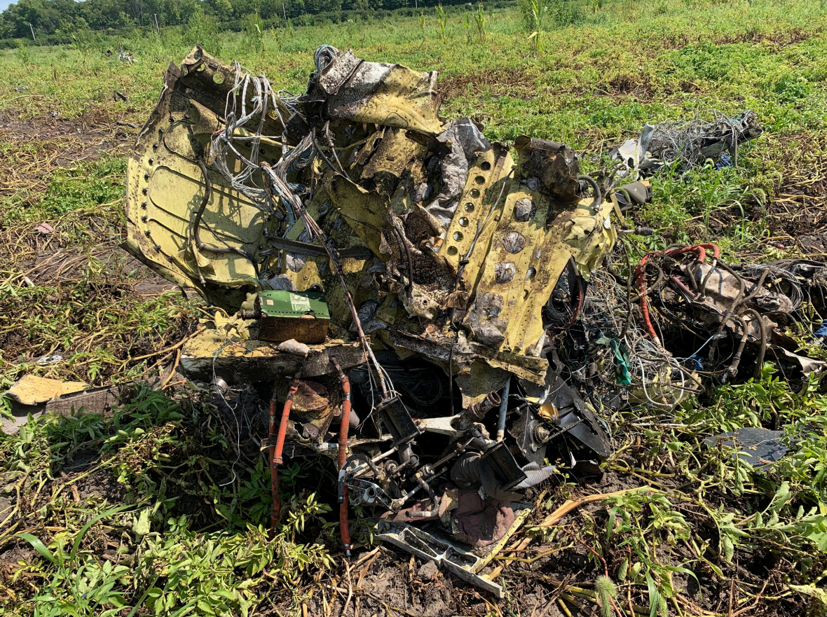
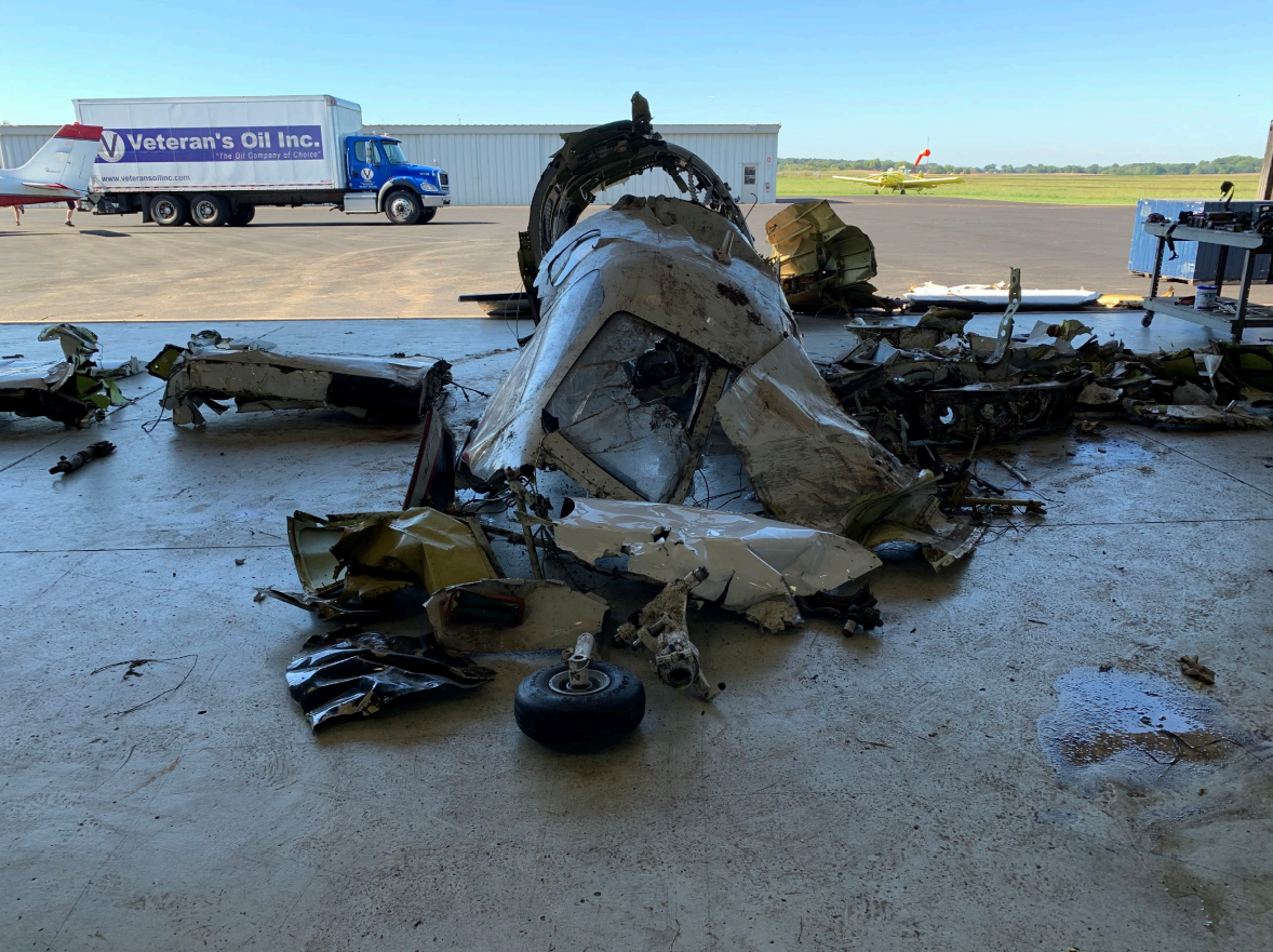
| Aircraft damage: | Destroyed |
| Category: | Accident |
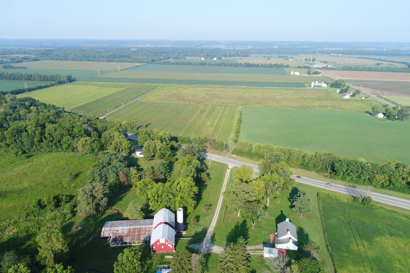
| Location: | SSW of Champaign County Grimes Field Airport (I74), Urbana, OH -
 United States of America United States of America
|
| Phase: | En route |
| Nature: | Private |
| Departure airport: | Port Clinton Airport, OH (PCW/KPCW) |
| Cincinnati Municipal Airport, OH (LUK/KLUK) | |
| Investigating agency: | NTSB |
| Confidence Rating: |
On August 20, 2021, about 1440 eastern daylight time, a Socata TBM 700A airplane, N700DT, was destroyed when it was involved in an accident near Urbana, Ohio. The pilot sustained fatal injuries. The airplane was operated as a Title 14 Code of Federal Regulations Part 91 personal flight.
The pilot was performing a short cross-country flight, which was his third solo flight in the high-performance single-engine airplane. The airplane departed and climbed to 20,000 ft mean sea level (msl) before beginning to descend. About 8 minutes before the accident, the airplane was southbound, descending to 11,000 ft, and the pilot established communications with air traffic control (ATC). About 4 minutes later, the controller cleared the pilot to descend to 10,000 ft msl and proceed direct to his destination; the pilot acknowledged the clearance.
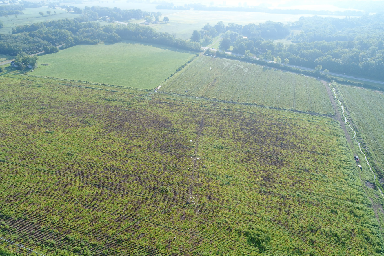
While descending through 13,000 ft msl, the airplane entered a descending left turn. The controller observed the left turn and asked the pilot if everything was alright; there was no response from the pilot. The controller’s further attempts to establish communications were unsuccessful. Following the descending left turn, the airplane entered a high speed, nose-down descent toward terrain. A witness observed the airplane at a high altitude in a steep nose-down descent toward the terrain. The witness noted no signs of distress, such as smoke, fire, or parts coming off the airplane, and he heard the airplane’s engine operating at full throttle. The airplane impacted two powerlines, trees, and the terrain in a shallow descent with a slightly left-wing low attitude.
Examination of the accident site revealed a long debris field that was consistent with an impact at a high speed and relatively shallow flightpath angle. All major components of the airplane were located in the debris field at the accident site. Examination of the airframe and engine revealed no preimpact mechanical malfunctions or failures with the airplane that would have precluded normal operation.
A performance study indicated the airplane entered a left roll and dive during which the airplane exceeded the airspeed, load factor, and bank angle limitations published in the Pilot’s Operating Handbook (POH). An important but unknown factor during these maneuvers was the behavior of the pilot and his activity on the flight controls during the initial roll and dive. The pilot responded normally to ATC communications only 98 seconds before the left roll started. It is difficult to reconcile an alert and attentive pilot with the roll and descent that occurred, but there is insufficient information available to determine whether the pilot was incapacitated or distracted during any part of the roll and dive maneuver.
Although all the available toxicological specimens contained ethanol (the alcohol contained in alcoholic drinks such as beer and wine), the levels were very low and below the allowable level for flight (0.04 gm/dl). While it is possible that some of the identified ethanol had been ingested, it is also possible that all or most of the identified ethanol was from sources other than ingestion (such as postmortem production). In either case, the levels were too low to have caused incapacitation. It is therefore unlikely that any effects from ethanol contributed to the circumstances of the accident. There was minimal available autopsy evidence to support any determination of incapacitation. As a result, it could not be determined from the available evidence whether medical incapacitation contributed to the accident.
Probable Cause: The pilot’s failure to arrest the airplane’s left roll and rapid descent for reasons that could not be determined based on the available evidence.
Accident investigation:
 |
|
Sources:
https://www.whio.com/news/local/state-patrol-responding-report-plane-crash-near-urbana/V24ZT74AZZD7LG6AUHIOZVDLNU/
https://www.daytondailynews.com/news/crews-responding-to-reported-airplane-crash-in-urbana/BFY3FAOHINFQNJ4MIQRA7ICWKU/
https://www.wdtn.com/news/local-news/state-troopers-en-route-to-alleged-plane-crash-in-urbana/
NTSB
https://flightaware.com/live/flight/N700DT/history/20210820/1800Z/KPCW/KLUK
https://registry.faa.gov/aircraftinquiry/Search/NNumberResult?nNumberTxt=700DT
https://globe.adsbexchange.com/?icao=a954eb&lat=40.691&lon=-83.672&zoom=9.0&showTrace=2021-08-20
https://cdn.jetphotos.com/full/2/48294_1233993769.jpg (photo)
Location
Images:
Photos: NTSB
Revision history:
| Date/time | Contributor | Updates |
|---|---|---|
| 20-Aug-2021 20:31 | Geno | Added |
| 20-Aug-2021 20:33 | Geno | Updated [Location] |
| 20-Aug-2021 21:43 | RobertMB | Updated [Time, Aircraft type, Registration, Cn, Operator, Total occupants, Phase, Nature, Departure airport, Destination airport, Source, Damage, Narrative] |
| 23-Aug-2021 18:26 | Anon. | Updated [Time, Source] |
| 24-Aug-2021 14:51 | Anon. | Updated [Source] |
| 31-Aug-2021 08:01 | aaronwk | Updated [Time, Source, Narrative, Category] |
Corrections or additions? ... Edit this accident description
The Aviation Safety Network is an exclusive service provided by:
Quick Links:
| ASN Home | Send Correction / Feedback |
| FSF Home | Disclaimer | Copyright |
| Contact Us | Privacy Policy |
| Press / Media |
 ©2024 Flight Safety Foundation