

ASN Wikibase Occurrence # 270229
This information is added by users of ASN. Neither ASN nor the Flight Safety Foundation are responsible for the completeness or correctness of this information.
If you feel this information is incomplete or incorrect, you can submit corrected information.
| Date: | Saturday 4 December 2021 |
| Time: | 18:40 |
| Type: |  Beechcraft V35 Bonanza |
| Owner/operator: | Private |
| Registration: | N7933M |
| MSN: | D-8265 |
| Year of manufacture: | 1966 |
| Total airframe hrs: | 6916 hours |
| Engine model: | Continental IO-550-B (6) |
| Fatalities: | Fatalities: 4 / Occupants: 4 |
| Aircraft damage: | Destroyed |
| Category: | Accident |
| Location: | near Visalia Municipal Airport (VIS/KVIS), Visalia, CA -
 United States of America United States of America
|
| Phase: | Initial climb |
| Nature: | Private |
| Departure airport: | Visalia Airport, CA (VIS/KVIS) |
| Sacramento-Executive Airport, CA (SAC/KSAC) | |
| Investigating agency: | NTSB |
| Confidence Rating: |
On December 4, 2021, about 1840 Pacific standard time (PST), a Beech V35 N7933M, was substantially damaged when it was involved in an accident near Visalia, California. The pilot and three passengers were fatally injured. The airplane was operated as a Title 14 Code of Federal Regulations Part 91 personal flight.
The instrument-rated pilot and three passengers departed on a night cross-country flight into instrument meteorological conditions (IMC). Automatic dependent surveillance-broadcast (ADS-B) flight track information indicated that the pilot departed and climbed the airplane to 495 ft mean sea level (msl), about 200 ft above ground level, before initiating a left turn. The airplane reached an altitude of 620 ft msl, then began a descent as the left turn continued. ADS-B data ended at an altitude of 395 ft about 660 ft northwest of the accident site. The airplane impacted flat, open terrain about 1 mile southwest of the departure end of the runway.
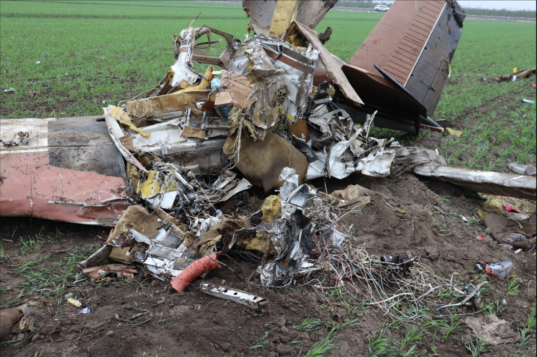
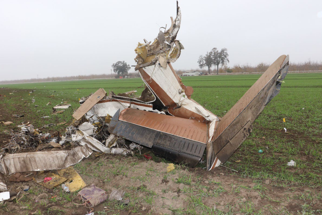
The wreckage was fragmented and distributed in a manner consistent with a high-energy impact with terrain. All major structural components of the airplane were located at the accident site. Examination of the airframe and engine revealed no evidence of any preexisting anomalies that would have precluded normal operation.
Review of weather information at the time of the accident indicated low cloud ceilings and restricted visibility due to mist, with ceilings near 300 ft above ground level and tops near 2,000 ft msl. The pilot obtained a weather briefing before departure.
The night IMC present at the time of the accident were conducive to the development of spatial disorientation and would have made control of the airplane by visual references difficult, especially if the pilot encountered restrictions to visibility, such as clouds, during the transitional phase of flight after takeoff and initial climb. The left turn initiated at low altitude, the pilot’s failure to maintain the climb, the tightening, descending turn, and the subsequent high-energy impact are all consistent with the known effects of spatial disorientation. Therefore, it is likely that the pilot was experiencing the effects of spatial disorientation when the accident occurred.
Postaccident toxicology testing revealed varying levels of ethanol in the pilot’s liver, kidney, and muscle tissue; a second lab did not report any ethanol in his muscle tissue. The ethanol concentration found in liver tissue was higher than the detected ethanol concentrations in kidney and muscle tissue. Isopropanol was also detected in liver tissue. Given the differing ethanol tissue concentrations, the state the body was recovered, and the presence of isopropanol in liver tissue, it is likely that the identified ethanol was from sources other than ingestion and did not contribute to this accident.
Probable Cause: The pilot’s loss of control due to spatial disorientation shortly after takeoff. Contributing to the accident was the pilot’s decision to depart into night instrument meteorological conditions.
Accident investigation:
 |
|
Sources:
https://eu.visaliatimesdelta.com/story/news/2021/12/05/breaking-details-foggy-plane-crash-visalia/8876711002/
https://abc30.com/plane-crash-tulare-visalia-airport/11302187/
NTSB
https://registry.faa.gov/AircraftInquiry/Search/NNumberResult?nNumberTxt=7933M
https://globe.adsbexchange.com/?icao=aac5f7&lat=36.318&lon=-119.415&zoom=15.7&showTrace=2021-12-05
https://flightaware.com/live/flight/N7933M/history/20211205/0237Z/KVIS/KVIS
https://www.youtube.com/watch?v=kXWAKBiOgdQ
Location
Images:

Photos: NTSB
Media:
NTSB investigating the 12/4/21 crash of a Beech V35 airplane in Visalia, California.
— NTSB_Newsroom (@NTSB_Newsroom) December 5, 2021
Revision history:
| Date/time | Contributor | Updates |
|---|---|---|
| 05-Dec-2021 07:26 | Captain Adam | Added |
| 05-Dec-2021 07:53 | RobertMB | Updated [Time, Registration, Cn, Operator, Location, Source, Embed code, Damage, Narrative] |
| 05-Dec-2021 14:21 | johnwg | Updated [Time, Source, Narrative, Category] |
| 05-Dec-2021 17:14 | aaronwk | Updated [Narrative] |
| 05-Dec-2021 21:54 | Captain Adam | Updated [Source, Narrative] |
| 07-Dec-2021 17:53 | joel caetano | Updated [Source] |
| 08-Dec-2021 19:27 | johnwg | Updated [Source] |
| 11-Dec-2021 16:49 | aaronwk | Updated [Destination airport, Narrative] |
| 04-Jan-2022 21:12 | Captain Adam | Updated [Source, Narrative] |
Corrections or additions? ... Edit this accident description
The Aviation Safety Network is an exclusive service provided by:
Quick Links:
| ASN Home | Send Correction / Feedback |
| FSF Home | Disclaimer | Copyright |
| Contact Us | Privacy Policy |
| Press / Media |
 ©2024 Flight Safety Foundation