

ASN Wikibase Occurrence # 270311
This information is added by users of ASN. Neither ASN nor the Flight Safety Foundation are responsible for the completeness or correctness of this information.
If you feel this information is incomplete or incorrect, you can submit corrected information.
| Date: | Tuesday 7 December 2021 |
| Time: | 21:24 |
| Type: |  Cessna 182 Skylane |
| Owner/operator: | TJP@JAX Inc |
| Registration: | N5776B |
| MSN: | 33776 |
| Year of manufacture: | 1956 |
| Total airframe hrs: | 9226 hours |
| Engine model: | Continental O-470-50 |
| Fatalities: | Fatalities: 1 / Occupants: 1 |
| Aircraft damage: | Destroyed |
| Category: | Accident |
| Location: | near Statesboro, GA -
 United States of America United States of America
|
| Phase: | En route |
| Nature: | Private |
| Departure airport: | Statesboro Municipal Airport, GA (TBR/KTBR) |
| Zephyrhills Airport, FL (ZPH/KZPH) | |
| Investigating agency: | NTSB |
| Confidence Rating: |
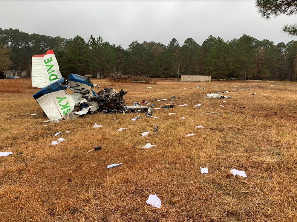
On December 7, 2021, at 2124 eastern standard time, a Cessna 182 airplane, N5776B, was destroyed when it was involved in an accident near Statesboro, Georgia. The pilot was fatally injured. The airplane was operated by the pilot as a Title 14 Code of Federal Regulations Part 91 personal flight.
The instrument-rated commercial pilot had conducted a cross-country flight to the airport arriving in the afternoon and, after attending a meeting, was returning to her home airport on a night visual flight rules (VFR) cross-country flight. Before the return flight, the pilot discussed with a family member her knowledge of a low cloud layer and her intention to stay low for the first 10 to 15 miles of the flight. At the time of departure, dark night conditions prevailed, and the airport was reporting an overcast cloud ceiling at 600 ft above ground level (agl).
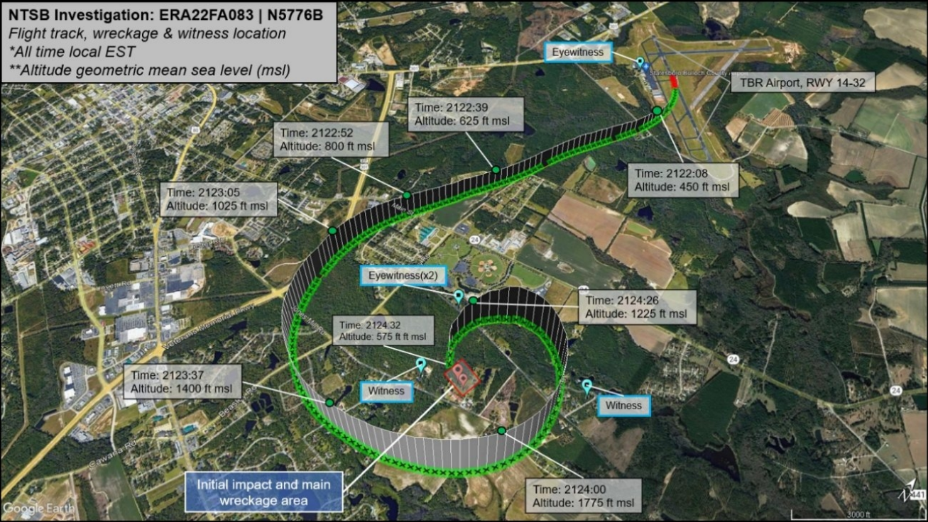
Review of automatic dependent surveillance-broadcast (ADS-B) data found that the airplane became airborne before the midpoint of the runway and turned right toward the destination airport. It then climbed to about 1,000 ft mean sea level (msl), which was about 800 ft agl, before entering a left turn about 2 miles south of the airport. The airplane continued in a left 360° tightening turn where a maximum altitude of about 1,800 ft msl was reached, which was subsequently followed by a rapid descent. Before the left 360° turn, the airplane likely entered the low cloud layer and never exited the clouds until a few seconds before it impacted with terrain. Multiple witnesses reported that the airplane’s engine noise was loud and continuous until impact.
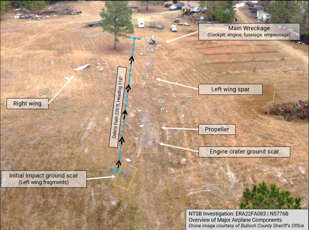
Examination of the wreckage revealed no evidence of preimpact mechanical malfunctions or failures with the airplane. Evaluation of the wreckage indicated that the airplane impacted terrain in a left turning descent at high speed.
Based upon ADS-B, meteorological, and astronomical data, the pilot initiated a VFR flight into known dark night instrument meteorological conditions, which would have prevented reliable control of the airplane using external visual cues. The circling and rapidly ascending and descending flight track was consistent with a pilot who was experiencing spatial disorientation, which resulted in a loss of control in flight and a high speed impact with terrain. The pilot’s instrument and night currency could not be determined.
The pilot’s toxicology report was positive for ethanol and quetiapine. Given that the ethanol was identified at a low level in muscle and that none was found in liver tissue, it is likely that the identified ethanol is from sources other than ingestion and unlikely that any effects from it contributed to the circumstances of the crash. Attempts were made to identify the underlying reason for the pilot’s use of quetiapine; however, the investigation was unable to do so. While the drug itself may cause neuropsychiatric effects, at the low levels likely present at the time of the event, it was unlikely to impair judgment. However, whether an underlying medical condition might have influenced the pilot’s decision-making could not be determined from the available information.
Probable Cause: The pilot’s decision to initiate a visual flight rules flight into dark night instrument meteorological conditions, which resulted in spatial disorientation and subsequent loss of control shortly after takeoff.
Accident investigation:
 |
|
Sources:
https://griceconnect.com/2021/12/the-jumping-place-skydive-center-pilot-killed-in-plane-crash/
https://www.usnews.com/news/best-states/georgia/articles/2021-12-08/small-plane-crashes-in-the-statesboro-area-of-south-georgia
NTSB
https://registry.faa.gov/AircraftInquiry/Search/NNumberResult?nNumberTxt=5776B
http://www.thejumpingplace.com/
https://cdn.jetphotos.com/full/5/93591_1436834994.jpg (photo)
Location
Images:
Media:
The NTSB is investigating the crash Tuesday of a Cessna 182 in Statesboro, Georgia.
— NTSB_Newsroom (@NTSB_Newsroom) December 8, 2021
Revision history:
| Date/time | Contributor | Updates |
|---|---|---|
| 08-Dec-2021 04:59 | Geno | Added |
| 08-Dec-2021 13:00 | johnwg | Updated [Time, Aircraft type, Registration, Cn, Operator, Phase, Nature, Source, Damage, Narrative, Category] |
| 08-Dec-2021 15:28 | aaronwk | Updated [Narrative] |
| 08-Dec-2021 23:44 | Captain Adam | Updated [Aircraft type, Operator, Source, Embed code] |
| 08-Dec-2021 23:57 | johnwg | Updated [Source, Embed code] |
| 09-Dec-2021 07:44 | RobertMB | Updated [Time, Phase, Source, Narrative] |
| 09-Dec-2021 14:48 | johnwg | Updated [Time, Source, Narrative] |
| 22-Dec-2021 14:36 | aaronwk | Updated [Time, Location, Phase, Destination airport, Source, Narrative, Category] |
| 17-Apr-2022 12:47 | Captain Adam | Updated [Narrative] |
Corrections or additions? ... Edit this accident description
The Aviation Safety Network is an exclusive service provided by:
Quick Links:
| ASN Home | Send Correction / Feedback |
| FSF Home | Disclaimer | Copyright |
| Contact Us | Privacy Policy |
| Press / Media |
 ©2024 Flight Safety Foundation