

ASN Wikibase Occurrence # 270421
This information is added by users of ASN. Neither ASN nor the Flight Safety Foundation are responsible for the completeness or correctness of this information.
If you feel this information is incomplete or incorrect, you can submit corrected information.
| Date: | Friday 10 December 2021 |
| Time: | 16:51 |
| Type: |  Beechcraft V35 Bonanza |
| Owner/operator: | Ron Eldridge Properties LLC |
| Registration: | N5704V |
| MSN: | D-8082 |
| Year of manufacture: | 1966 |
| Total airframe hrs: | 4256 hours |
| Engine model: | Continental IO-520-BB |
| Fatalities: | Fatalities: 2 / Occupants: 2 |
| Aircraft damage: | Substantial |
| Category: | Accident |
| Location: | near Crab Orchard, KY -
 United States of America United States of America
|
| Phase: | En route |
| Nature: | Private |
| Departure airport: | Baxley Municipal Airport, GA (KBHC) |
| Danville-Stuart Powell Field, KY (KDVK) | |
| Investigating agency: | NTSB |
| Confidence Rating: |
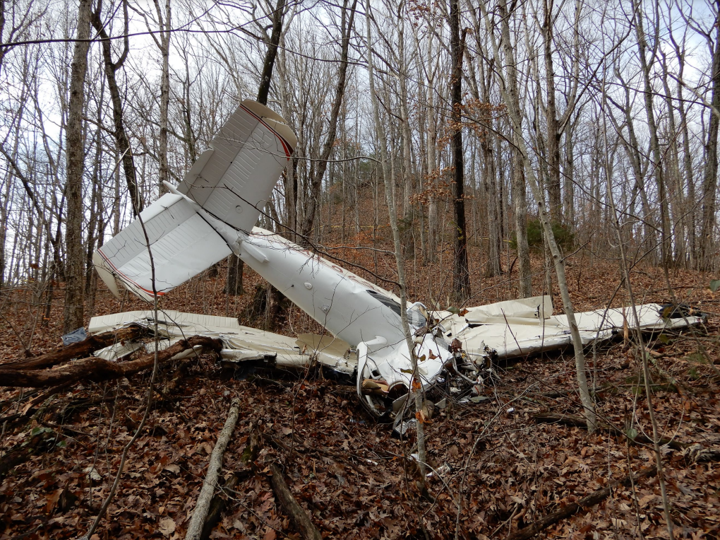
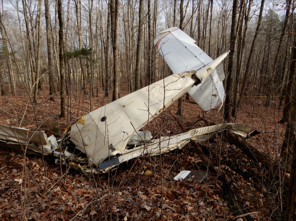
On December 10, 2021, about 1651 eastern standard time, a Beech V35, N5704V, was substantially damaged when it was involved in an accident near Crab Orchard, Kentucky. The private pilot and one passenger were fatally injured. The airplane was operated as a Title 14 Code of Federal Regulations Part 91 personal flight.
The noninstrument-rated pilot was nearing his home airport at the end of a cross-country flight. Automatic Dependent surveillance-broadcast (ADS-B) and weather data indicated that the flight encountered instrument meteorological conditions (IMC) while enroute to the destination airport. These conditions included low ceilings, fog, mist, and light rain. The pilot was not communicating with air traffic control at the time of the accident, and there was no evidence that he obtained a weather briefing before the flight.
The ADS-B data showed that the airplane began a left 270° turn to the east, followed by a right turn until the airplane was heading north. The airplane then pitched up, gaining about 500 ft as it approached rapidly rising terrain. The last two data points indicated a descent, and the last data point was located very close to the accident site. The owner of the land where the airplane crashed did not see the accident; however, he heard the airplane descending and described the engine sound as “very loud” and continuing with no interruption until he heard the noise of the ground impact.
The airplane impacted rising terrain about 13 miles southeast of the destination airport. The path through the trees and the general destruction of the wreckage were indicative of an inflight loss of control and a collision with terrain at high speed and at a high descent angle. Based upon ADS-B and meteorological data, the pilot continued a visual flight rules flight into instrument meteorological conditions, which would have prevented reliable control of the airplane using external visual cues. The turns and rapid ascents and descents at the end of the flight track were consistent with a pilot who was experiencing spatial disorientation, which resulted in a loss of control in flight and a high-speed impact with terrain.
Examination of the wreckage revealed that the engine-driven vacuum pump drive coupling was fractured; no evidence of any other preaccident malfunctions or failures of the airframe or engine was found. Disassembly of the attitude gyro revealed no rotational scoring signatures inside the rotor housing or on the rotor; this finding suggested that the vacuum pump was not operating before ground impact. Further examination revealed that one of the fasteners that secured the pump’s inlet cover plate to the stator housing was missing, and the stator housing and inlet cover plate were visibly offset relative to one another in the lateral direction; this condition likely led to the eventual seizure of the pump and the failure of the drive coupling. The airplane’s maintenance records were lost in a tornado the morning after the accident; therefore, the history of the pump was not determined. Although the exact time of pump failure could not be determined, it is unlikely that the pump failed at the same time the flight entered IMC; rather, it is likely the pump failed at some earlier time.
The airplane was equipped with a standby vacuum system operated by the differential between engine intake manifold pressure and ambient atmospheric pressure; this system would operate only when engaged by the pilot. While impact damage to the system components made it impossible to determine if the standby system was in operation at the time of the accident, the lack of rotational signatures on the attitude gyro supports that it was not operating/activated. Therefore, it is likely that the airplane’s vacuum-powered flight instruments, including the attitude indicator, were inoperative, increasing the probability of a spatial disorientation event.
Probable Cause: The noninstrument-rated pilot’s decision to continue the visual flight rules flight into instrument meteorological conditions, which resulted in spatial disorientation and a loss of airplane control and collision with terrain. Contributing to the accident was the inoperative engine-driven vacuum pump.
Accident investigation:
 |
|
Sources:
https://www.wkyt.com/2021/12/10/two-killed-small-plane-crash-lincoln-county/
https://www.lex18.com/news/sheriff-deadly-plane-crash-in-lincoln-county
https://www.wtvq.com/small-private-plane-with-two-on-board-crashes-in-lincoln-county/
NTSB
https://data.ntsb.gov/Docket?ProjectID=104384
https://registry.faa.gov/AircraftInquiry/Search/NNumberResult?nNumberTxt=5704V
https://flightaware.com/live/flight/N5704V
https://globe.adsbexchange.com/?icao=a75161&lat=34.462&lon=-84.159&zoom=7.1&showTrace=2021-12-10&leg=3
https://www.airport-data.com/images/aircraft/000/468/468048.jpg (photo)
Location
Images:
Media:
The NTSB is investigating the crash Friday of a Beech V35 airplane in Crab Orchard, Kentucky.
— NTSB_Newsroom (@NTSB_Newsroom) December 11, 2021
Revision history:
| Date/time | Contributor | Updates |
|---|---|---|
| 11-Dec-2021 01:05 | Geno | Added |
| 11-Dec-2021 03:08 | RobertMB | Updated [Time, Aircraft type, Operator, Location, Nature, Source, Embed code, Damage, Narrative] |
| 11-Dec-2021 04:00 | johnwg | Updated [Operator, Nature, Departure airport, Destination airport, Source, Embed code, Narrative, Category] |
| 11-Dec-2021 06:47 | RobertMB | Updated [Operator, Nature, Departure airport, Destination airport, Narrative] |
| 11-Dec-2021 09:24 | Captain Adam | Updated [Registration, Cn, Operator, Phase, Destination airport, Source, Narrative] |
| 11-Dec-2021 15:22 | johnwg | Updated [Time, Operator, Departure airport, Source] |
| 11-Dec-2021 16:49 | aaronwk | Updated [Departure airport, Narrative] |
| 11-Dec-2021 17:06 | johnwg | Updated [Time, Operator, Source] |
| 05-Jan-2022 21:40 | Captain Adam | Updated [Location, Source, Damage, Narrative, Category] |
Corrections or additions? ... Edit this accident description
The Aviation Safety Network is an exclusive service provided by:
Quick Links:
| ASN Home | Send Correction / Feedback |
| FSF Home | Disclaimer | Copyright |
| Contact Us | Privacy Policy |
| Press / Media |
 ©2024 Flight Safety Foundation