

ASN Wikibase Occurrence # 275334
This information is added by users of ASN. Neither ASN nor the Flight Safety Foundation are responsible for the completeness or correctness of this information.
If you feel this information is incomplete or incorrect, you can submit corrected information.
| Date: | Wednesday 9 February 2022 |
| Time: | 17:48 |
| Type: |  Cirrus SR22 |
| Owner/operator: | Craigair LLC |
| Registration: | N987AA |
| MSN: | 0513 |
| Year of manufacture: | 2003 |
| Total airframe hrs: | 2409 hours |
| Engine model: | Continental IO-550-N7B |
| Fatalities: | Fatalities: 0 / Occupants: 1 |
| Aircraft damage: | Substantial |
| Category: | Accident |
| Location: | Moore County Airport (SOP/KSOP), Pinehurst, NC -
 United States of America United States of America
|
| Phase: | Landing |
| Nature: | Private |
| Departure airport: | Erwin Airport, NC (HRJ) |
| Southern Pines-Pinehurst Airport, NC (SOP/KSOP) | |
| Investigating agency: | NTSB |
| Confidence Rating: |
The Cirrus pilot reported making a radio call on what he thought was the published common traffic advisory frequency (CTAF) when the flight was 10 miles away, then continued to the airport for a straight-in approach to runway 23 making radio calls. During the same time frame, a flightcrew member of an Army helicopter announced on the CTAF when their flight was on 10, 5, and 2 nautical mile final for runway 5. The Cirrus pilot indicated that he did not hear any communication on the CTAF and he was unable to activate the runway lights using the CTAF. When the Cirrus flight was between 2 and 3 miles from the airport, he saw a helicopter at the opposite end of the runway moving to the east, adding that the sun was in his eyes which was “definitely a factor.” He did not hear the helicopter on the selected CTAF frequency and made a radio call on the CTAF that he was on short final approach. A flightcrew member of the military helicopter reported they did not hear any advisory call from the airplane and after they spotted it, the IP took the controls and turned to the right (east) to avoid a collision. The Cirrus pilot indicated that after flying over the airport property fence, he looked to his left and noted a military helicopter several hundred feet above his altitude. He continued his descent to runway 23 and when the flight was about 15 to 20 ft AGL the flight encountered, “very strong turbulence” which caused the left wing to drop. He recovered from that and then when the flight was between 5 and 10 ft AGL encountered another round of “very strong turbulence” which made the right wing contact the runway resulting in substantial damage to the wing. The airplane went to the right and skidded into the grass. The military helicopter continued to the east and reported that since they could not affect the situation continued with the training.
A short audio recording of the CTAF recorded a flightcrew member of the military helicopter announcing they were on a 2 mile final for runway 5, followed by an announcement that they were departing to the east off of runway centerline.
Postaccident examination of the radios of the Cirrus airplane revealed the pilot had selected the #2 radio to transmit, which was set to 122.700 MHz. That frequency was the departure airport CTAF. The accident airport published CTAF was 123.05MHz.
Probable Cause: The in-flight encounter while on final approach with high-speed trailing vortices from a military helicopter, resulting in abnormal runway contact. Contributing to the accident was the Cirrus pilot’s incorrect selection of the common traffic advisory frequency on the aircraft’s radio.
Accident investigation:
 |
|
Sources:
https://sandhillssentinel.com/small-plane-crashes-upon-landing-at-moore-county-airport/
https://www.jetphotos.com/photo/452078 (photo)
NTSB
Location
Images:
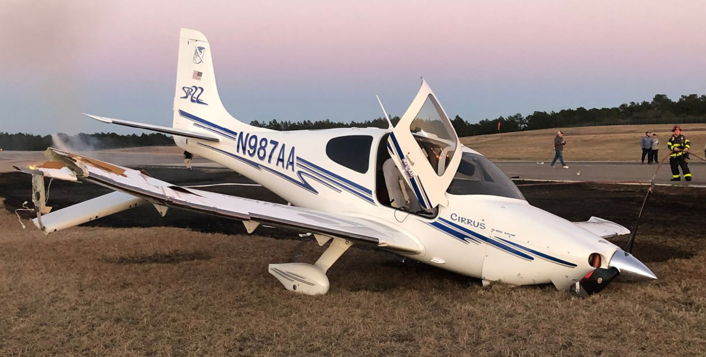
Photo: NTSB
Revision history:
| Date/time | Contributor | Updates |
|---|---|---|
| 10-Feb-2022 05:36 | Geno | Added |
| 10-Feb-2022 06:04 | Geno | Updated [Date] |
| 14-Jun-2022 22:56 | Captain Adam | Updated [Time, Location, Nature, Departure airport, Source, Narrative, Category, Accident report, Photo] |
Corrections or additions? ... Edit this accident description
The Aviation Safety Network is an exclusive service provided by:
Quick Links:
| ASN Home | Send Correction / Feedback |
| FSF Home | Disclaimer | Copyright |
| Contact Us | Privacy Policy |
| Press / Media |
 ©2024 Flight Safety Foundation