

ASN Wikibase Occurrence # 275476
This information is added by users of ASN. Neither ASN nor the Flight Safety Foundation are responsible for the completeness or correctness of this information.
If you feel this information is incomplete or incorrect, you can submit corrected information.
| Date: | Sunday 13 February 2022 |
| Time: | 10:20 |
| Type: |  Piper PA-46-500TP Malibu Meridian |
| Owner/operator: | Quadrant Investments 1 LLC |
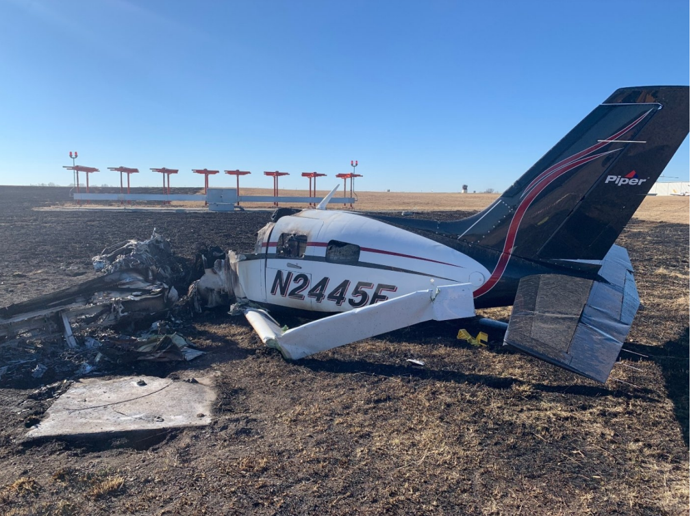
| Registration: | N2445F |
| MSN: | 4697480 |
| Year of manufacture: | 2012 |
| Fatalities: | Fatalities: 1 / Occupants: 1 |
| Aircraft damage: | Destroyed |
| Category: | Accident |
| Location: | Olathe-Johnson County Executive Airport (OJC/KOJC), Olathe, KS -
 United States of America United States of America
|
| Phase: | Initial climb |
| Nature: | Private |
| Departure airport: | Olathe-Johnson County Executive Airport, KS (OJC/KOJC) |
| Albuquerque International Airport, NM (ABQ/KABQ) | |
| Investigating agency: | NTSB |
| Confidence Rating: |
On February 13, 2022, at 1020 central standard time, a Piper PA-46-500TP, N2445F, was destroyed when it was involved in an accident at the Johnson County Executive Airport (OJC), Olathe, Kansas. The pilot was fatally injured. The airplane was operated as a Title 14 Code of Federal Regulations Part91 personal flight.
The airplane had recently undergone an annual inspection, and the pilot planned to fly the airplane back to his home base. After receiving clearance from air traffic control, the pilot proceeded to take off. The airplane accelerated and reached a peak groundspeed of 81 kts about 2,075 ft down the 4,097-ft runway. Once airborne, the airplane drifted slightly to the right and the pilot radioed an urgent need to return to the airport. The controller cleared the airplane to land and no further transmissions were received from the accident airplane. The airplane’s flight path showed that it slowed before turning back toward the left and the airplane’s speed continued to decrease throughout the remainder of the data. The final data point recorded the airplane at a groundspeed of 45 kts. The groundspeed would equate to 60 kts airspeed when considering the 15-kt headwind. The stall speed chart for the airplane listed the minimum stall speed for any configuration as 64 kts.
Postaccident examinations of the airframe and engine revealed no evidence of mechanical malfunctions or failures that would have precluded normal operation. External and internal engine damage indicated that the engine was producing power at the time of impact, but the amount of power output could not be determined.
Based on the available information, the pilot perceived an urgent need to return the airplane to the airport; however, due to the amount of damage from the impact and postimpact fire, the reason that the pilot was returning to the airport could not be determined. Stall speed information for the airplane, the recorded winds, and flight track data, indicated that the airplane encountered an aerodynamic stall before impacting the ground near the departure end of the runway. Since the airplane stalled and impacted the ground before reaching the perimeter of the airport, the pilot may not have had sufficient altitude to execute a forced landing to the empty field off the departure end of the runway.
Probable Cause: The unknown emergency that warranted a return to the airport and the airspeed decay which resulted in an aerodynamic stall.
Accident investigation:
 |
|
Sources:
https://fox4kc.com/news/plane-crashes-near-johnson-county-executive-airport/
https://www.kansascity.com/news/local/article258356893.html
https://data.ntsb.gov/Docket?ProjectID=104632
https://flightaware.com/live/flight/N2445F/history/20220213/1633Z/KOJC/KABQ
https://globe.adsbexchange.com/?icao=a241e8&lat=38.854&lon=-94.737&zoom=17.7&showTrace=2022-02-13&trackLabels
Location
Images:
Photo(c): NTSB
Media:
Here's a look at the plane crash this morning at Johnson County Executive Airport. According to eyewitnesses, the plane had trouble on takeoff and slammed into the ground before catching fire.
— Matt Evans (@MattEvansKMBC) February 13, 2022
We are expecting an update from fire and police soon.@kmbc
📷: Michael Carey pic.twitter.com/EDeuSkA8Jp
NTSB is investigating the Feb. 13, 2022, crash of a Piper PA-46-500TP near Olathe, Kansas.
— NTSB_Newsroom (@NTSB_Newsroom) February 13, 2022
Revision history:
| Date/time | Contributor | Updates |
|---|---|---|
| 13-Feb-2022 17:36 | gerard57 | Added |
| 13-Feb-2022 17:36 | gerard57 | Updated [Date] |
| 13-Feb-2022 18:02 | gerard57 | Updated [Time] |
| 13-Feb-2022 18:05 | harro | Updated [Aircraft type, Registration, Cn, Location, Departure airport, Source] |
| 13-Feb-2022 18:09 | harro | Updated [Time, Destination airport, Source, Embed code, Narrative, Category] |
| 13-Feb-2022 21:14 | Captain Adam | Updated [Operator, Total fatalities, Total occupants, Other fatalities, Source, Embed code, Narrative] |
| 14-Feb-2022 06:08 | aaronwk | Updated [Time, Embed code, Narrative] |
| 04-Mar-2022 15:29 | aaronwk | Updated [Source, Narrative, Category] |
| 04-Mar-2022 15:30 | harro | Updated [Narrative] |
| 08-Mar-2022 20:22 | Captain Adam | Updated [Source, Narrative, Photo] |
| 15-Dec-2023 18:11 | Captain Adam | Updated [Aircraft type, Location, Phase, Source, Embed code, Narrative, Accident report] |
Corrections or additions? ... Edit this accident description
The Aviation Safety Network is an exclusive service provided by:
Quick Links:
| ASN Home | Send Correction / Feedback |
| FSF Home | Disclaimer | Copyright |
| Contact Us | Privacy Policy |
| Press / Media |
 ©2024 Flight Safety Foundation