

ASN Wikibase Occurrence # 279161
This information is added by users of ASN. Neither ASN nor the Flight Safety Foundation are responsible for the completeness or correctness of this information.
If you feel this information is incomplete or incorrect, you can submit corrected information.
| Date: | Friday 10 June 2022 |
| Time: | 08:00 |
| Type: |  Mooney M20K 305 Rocket |
| Owner/operator: | 305L Air Holdings LLC |
| Registration: | N305L |
| MSN: | 25-0616 |
| Fatalities: | Fatalities: 1 / Occupants: 1 |
| Aircraft damage: | Destroyed |
| Category: | Accident |
| Location: | near Camarillo Airport (CMA/KCMA), Camarillo, CA -
 United States of America United States of America
|
| Phase: | Initial climb |
| Nature: | Private |
| Departure airport: | Camarillo Airport, CA (KCMA) |
| Phoenix-Deer Valley Airport, AZ (DVT/KDVT) | |
| Investigating agency: | NTSB |
| Confidence Rating: |
On June 10, 2022, about 0800 Pacific daylight time, a Mooney M20K, N305L was destroyed when it was involved in an accident near Camarillo, California. The pilot was fatally injured. The airplane was operated as a Title 14 Code of Federal Regulations Part 91 personal flight.
The instrument-rated pilot planned to fly to his home base. The departure airport was enveloped in marine layer conditions with low visibility, mist, and clouds tops between 400 and 1,600 ft. The pilot received this weather information during a briefing about 30 minutes before departure, during which he filed an instrument flight rules (IFR) flight plan with a visual flight rules (VFR)-on-top clearance.
The pilot was unfamiliar with the airport. After making a wrong turn, the pilot was given taxi instructions to the departure runway. The engine run-up and takeoff appeared uneventful, and the pilot’s communication with the control tower was routine.
Shortly after takeoff, the airplane likely entered the clouds, and the pilot was instructed to contact the departure controller. Although the pilot acknowledged the instruction, he did not contact the departure controller.
A short time later, a witness who was driving along a freeway parallel to the departure runway saw a low-flying airplane that was traveling perpendicular to the takeoff direction. The airplane did not appear to have any trailing smoke or vapors. The airplane then impacted the ground just past the freeway. A video from the witness’ dashboard-mounted camera captured the flames from the impact and showed the fog and low clouds enveloping the area. The reported weather observations matched the weather conditions observed in both the security camera video and the dashboard camera video.
Engine and propeller evidence and the associated propeller ground scars indicated that the engine was producing high levels of power at impact. The airplane was equipped with conventional vacuum and electrically powered flight instruments. Although the autopilot and flight instruments were destroyed due to impact and thermal damage, the vacuum pump, which had recently been installed, was recovered and found to be operational. Also, evidence within the wreckage indicated that the airplane was configured appropriately for the initial takeoff climb, with the landing gear retracted and the trim set for takeoff. Thus, the loss of control did not occur due to a loss of engine power, a preimpact mechanical malfunction or failure, or pilot error in configuring the airplane for takeoff.
The pilot’s logbook showed only the flight time required to meet Federal Aviation Administration (FAA) currency requirements; and based on his entries, while he had undergone a flight review the year prior, it appeared that he was not instrument current at the time of the accident
The airport area is provided with radar and automatic dependent surveillance-broadcast (ADSB) coverage that starts between 250 and 500 ft above ground level (agl), but neither system tracked the airplane. Thus, the airplane likely did not reach an altitude that would allow the airplane to be tracked after it entered the clouds. The pilot was required to make a slight right turn after departure; however, the airplane’s rapid change in direction after takeoff along with its high impact speed (as shown by ground scar and video evidence) are consistent with the pilot encountering spatial disorientation in the clouds, resulting in a loss of airplane control. It is possible that that the pilot might have been distracted as he configured the airplane for the initial climb and reached over to switch to the departure controller’s frequency.
The pilot had cardiovascular disease, including moderate coronary artery disease, an implanted pacemaker/defibrillator, and mitral valve replacement. The pilot’s medical certificate had expired 6 years before the accident. In 2019 he began flying under the provisions of BasicMed, which is an alternate way for pilots to fly without holding an FAA medical certificate. The pilot’s history of mitral valve replacement would have required a special issuance medical certificate for BasicMed. No such issuance was obtained; therefore the pilot did not possess valid medical certification for the flight.
The pilot’s cardiovascular disease was associated with an increased risk of sudden impairment or incapacitating cardiovascular event such as ventricular arrhythmia, heart attack, or stroke. No forensic evidence indicated that such an event occurred. However, such events do not leave reliable autopsy evidence if the event occurs just before death, and no data were available from the pilot’s implanted pacemaker/defibrillator. Thus, the investigation was unable to determine if sudden incapacitation or impairment was a factor in this accident.
Probable Cause: The pilot’s spatial disorientation and loss of airplane control after entering instrument meteorological conditions shortly after takeoff.
Accident investigation:
 |
|
Sources:
https://www.foxla.com/news/oxnard-plane-crash
https://eu.vcstar.com/story/news/local/communities/oxnard/2022/06/10/plane-crashes-oxnard-field/7581132001/
https://data.ntsb.gov/Docket?ProjectID=105237
https://registry.faa.gov/AircraftInquiry/Search/NNumberResult?nNumberTxt=305L
https://flightaware.com/live/flight/N305L/history/20220610/1500Z/KCMA/KDVT
https://cdn.jetphotos.com/full/2/80408_1303879294.jpg (photo)
Location
Images:
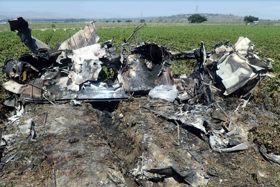
Photo: NTSB
Media:
NOW: Pilot has died after Mooney fixed wing crashed into strawberry field near Camarillo Airport. @VCFD says plane first clipped the roof of a church building on the other side of the 101 freeway. No other injuries. Plane had just taken off and was reportedly headed to AZ @foxla pic.twitter.com/W8DbzRSBC2
— Gigi Graciette (@GigiGraciette) June 10, 2022
Revision history:
| Date/time | Contributor | Updates |
|---|---|---|
| 10-Jun-2022 17:15 | harro | Added |
| 10-Jun-2022 17:21 | harro | Updated [Location, Departure airport, Source, Embed code, Narrative, Category] |
| 10-Jun-2022 17:27 | harro | Updated [Time, Aircraft type, Registration, Cn, Operator, Destination airport, Source] |
| 10-Jun-2022 17:31 | harro | Updated [Narrative] |
| 10-Jun-2022 17:43 | RobertMB | Updated [Time, Aircraft type, Operator, Location, Nature, Source, Narrative] |
| 10-Jun-2022 17:44 | RobertMB | Updated [Embed code] |
| 10-Jun-2022 17:49 | RobertMB | Updated [Source, Embed code] |
| 11-Jun-2022 00:27 | johnwg | Updated [Location, Source, Embed code, Narrative, Category] |
| 06-Jul-2022 22:48 | Captain Adam | Updated [Time, Location, Source, Narrative, Category] |
| 21-Apr-2024 13:28 | Captain Adam | Updated [Time, Location, Source, Narrative, Accident report, Photo] |
| 21-Apr-2024 13:29 | Captain Adam | Updated [Narrative] |
Corrections or additions? ... Edit this accident description
The Aviation Safety Network is an exclusive service provided by:
Quick Links:
| ASN Home | Send Correction / Feedback |
| FSF Home | Disclaimer | Copyright |
| Contact Us | Privacy Policy |
| Press / Media |
 ©2024 Flight Safety Foundation