

ASN Wikibase Occurrence # 282784
This information is added by users of ASN. Neither ASN nor the Flight Safety Foundation are responsible for the completeness or correctness of this information.
If you feel this information is incomplete or incorrect, you can submit corrected information.
| Date: | Sunday 11 September 2022 |
| Time: | 18:59 |
| Type: |  Cessna 172M |
| Owner/operator: | Thunderbird Aviation LLC |
| Registration: | N9049H |
| MSN: | 17265918 |
| Year of manufacture: | 1975 |
| Engine model: | Lycoming O320 |
| Fatalities: | Fatalities: 0 / Occupants: 2 |
| Aircraft damage: | Substantial |
| Category: | Accident |
| Location: | Fort Collins, CO -
 United States of America United States of America
|
| Phase: | Manoeuvring (airshow, firefighting, ag.ops.) |
| Nature: | Private |
| Departure airport: | Boulder Municipal Airport, CO (WBU/KBDU) |
| Boulder Municipal Airport, CO (WBU/KBDU) | |
| Investigating agency: | NTSB |
| Confidence Rating: |
On September 11, 2022, about 1859 mountain daylight time, a Cessna 172 airplane, N9049H, sustained substantial damage when it was involved in an accident near Fort Collins, Colorado. The pilot and flight instructor sustained minor injuries. The airplane was operated as a Title 14 Code of Federal Regulations Part 91 personal flight.
The pilot and flight instructor were conducting a personal flight over a reservoir when they descended and flew at a low altitude over two boats on the water. After passing the second boat, they turned west into a cove and impacted rising terrain about 1 mile west of the shoreline, which resulted in substantial damage to the fuselage and both wings.
Following the accident, the flight instructor made differing and conflicting statements to the National Transportation Safety Board (NTSB). The first statement was that there was an engine malfunction and to avoid landing on the water or impacting boats on the surface, he elected to make a climbing right turn to the west, away from the lake, and the airplane subsequently impacted rising terrain. In a written statement provided by the flight instructor, he stated that the power had been reduced to “see more of the scenery.” Shortly thereafter, the pilot flying told him that he could not climb due to a jammed elevator. The flight instructor stated that he could only control the airplane through the use of trim and power manipulation. To avoid congested areas, they maneuvered to the reservoir and attempted to free the jammed elevator by “wiggling the flight control in and out,” which resulted in the airplane pitching down. He stated that after adding power and retrimming the airplane, he elected to fly west into the valley to look for a landing area.
A review of flight track data revealed that the airplane did not descend as described in the written statement, but instead flew east to west over the reservoir and descended during a 270° turn over the reservoir that was initiated about mid-channel. The airplane traversed about 1.6 miles south along the reservoir before it turned west and climbed. The last recorded altitude was about 6,075 ft msl near the accident location.
Photographs provided by a witness show the airplane low over the water as it approached one of only three visible boats. At first, the airplane appeared headed toward the shore, but made a left turn toward the first boat. After making a very low pass over the boat, the airplane made a steep climb, followed by a steep right turn, and then flew at a low altitude over the second boat. After passing the second boat, the airplane appeared to depart toward a valley.
Postaccident examinations by the Federal Aviation Administration and the NTSB revealed no mechanical malfunctions or anomalies that would have precluded normal operation of the engine or flight controls.
Probable Cause: The pilot’s failure to maintain clearance from rising terrain while intentionally maneuvering the airplane at low altitudes, which resulted in substantial damage to the fuselage and both wings.
Accident investigation:
 |
|
Sources:
https://www.cbsnews.com/colorado/news/plane-crash-horsetooth-reservoir-larimer-county/
https://www.reporterherald.com/2022/09/11/small-plane-crash-reported-near-horsetooth-reservoir/
https://www.cbsnews.com/colorado/news/pilot-seen-flying-boats-horsetooth-reservoir-before-crash/
https://www.avweb.com/aviation-news/pilot-charged-after-allegedly-buzzing-boats-then-crashing/?MailingID=1212
FAA
NTSB
Location
Images:

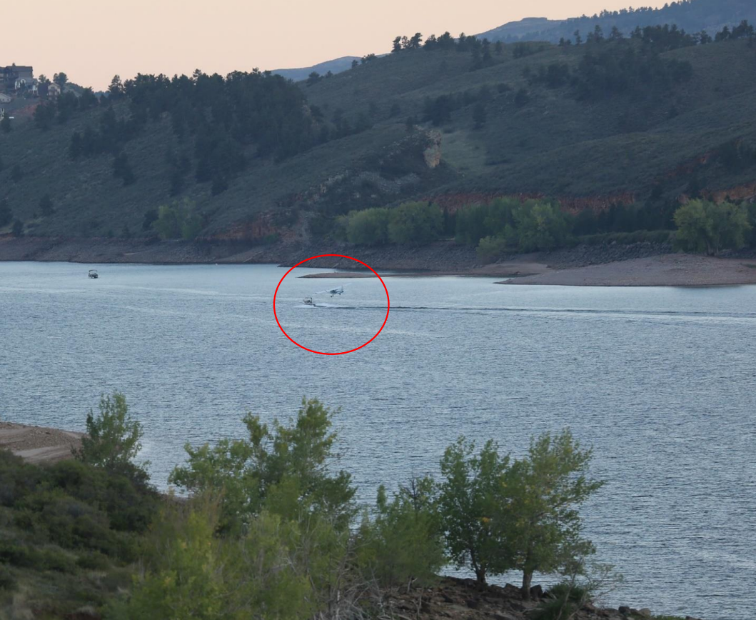
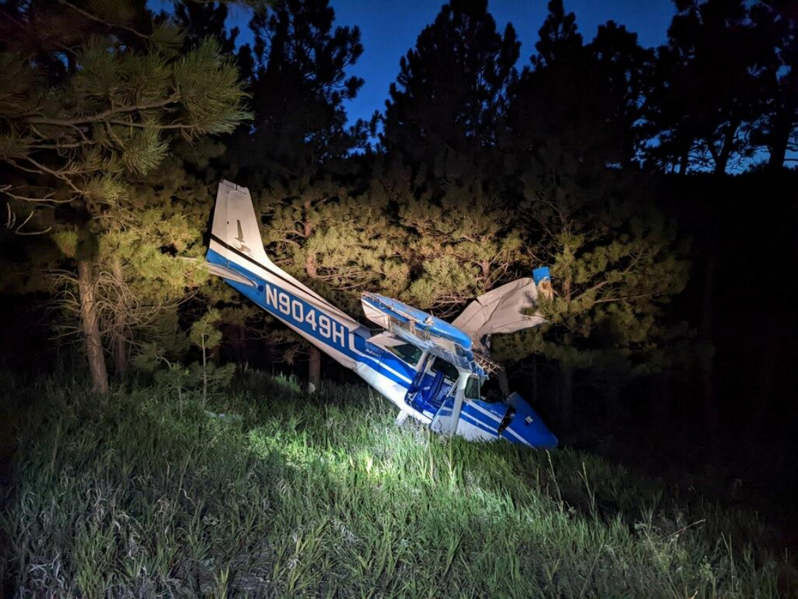
Photo: NTSB
Revision history:
| Date/time | Contributor | Updates |
|---|---|---|
| 12-Sep-2022 05:22 | Geno | Added |
| 12-Sep-2022 14:55 | harro | Updated [Aircraft type, Registration, Cn, Operator, Location, Source, Damage, Narrative] |
| 14-Sep-2022 06:16 | Anon. | Updated [Photo] |
| 15-Sep-2022 18:50 | YimmyTedeski | Updated [Departure airport, Destination airport, Source] |
| 27-Sep-2022 20:05 | Captain Adam | Updated [Time, Phase, Nature, Source, Narrative, Category] |
Corrections or additions? ... Edit this accident description
The Aviation Safety Network is an exclusive service provided by:
Quick Links:
| ASN Home | Send Correction / Feedback |
| FSF Home | Disclaimer | Copyright |
| Contact Us | Privacy Policy |
| Press / Media |
 ©2024 Flight Safety Foundation