

| Date: | Saturday 23 December 2017 |
| Time: | 10:10 |
| Type: |  Britten-Norman BN-2A Islander |
| Owner/operator: | North Coast Aviation |
| Registration: | P2-ISM |
| MSN: | 227 |
| Year of manufacture: | 1970 |
| Total airframe hrs: | 32232 hours |
| Engine model: | Lycoming IO-540-K1B5 |
| Fatalities: | Fatalities: 1 / Occupants: 1 |
| Aircraft damage: | Destroyed, written off |
| Category: | Accident |
| Location: | 11,3 km S of Dinangat Village -
 Papua New Guinea Papua New Guinea
|
| Phase: | En route |
| Nature: | Cargo |
| Departure airport: | Derim Airport (DER/AYDE) |
| Lae-Nadzab Airport (LAE/AYNZ) | |
| Investigating agency: | PNG AIC |
| Confidence Rating: |
A BN-2A Islander aircraft, registered P2-ISM, owned and operated by North Coast Aviation, impacted a ridge, at about 9,500 ft, that runs down towards the Sapmanga Valley from the Sarawaget Ranges, Morobe Province in Papua New Guinea. The pilot elected to track across the Sarawaget ranges, from Derim to Nadzab Airport, not above 10,000 ft. GPS recorded track data immediately prior to the last GPS fix showed that the aircraft was on a shallow descent towards the ridge at that time. The aircraft impacted the ridge about 150 metres beyond the last fix.
During the search for the aircraft, what appeared to be the right aileron was found hanging from a tree near the top of the heavily-timbered, densely-vegetated ridge. The remainder of the wreckage was found about 150 m from the aileron along the projected track. The aircraft impacted the ground in a steep nose-down, right wing-low attitude. The majority of the aircraft wreckage was contained at the ground impact point. The aircraft was destroyed by impact forces. The pilot, the sole occupant, initially survived. The pilot had made contact with one of the operators pilots at 16:15 on 23 December.
Bad weather in the area prevented a recovery until December 26. By that time the pilot had died of his injuries.
Causes [Contributing factors]:
Cloud build up along the pilot's chosen route may have forced him to manoeuvre closer than normal to the ridge, in order to avoid flying into the cloud.
The aircraft's right wing struck a tree protruding from the forest canopy during controlled flight into terrain. It is likely that the right aileron mass balance became snagged on the tree and rapidly dislodged the aileron from the wing. The loss of roll control, and the aerodynamic differential, forced the aircraft to descend steeply through the forest and impacted terrain.
Other factor
While not contributing to this accident, the lack of appropriate and effective Search and Rescue capability, and the lack of a Rescue Coordination Centre established, maintained and operated in accordance with ICAO Annex 12 Standards, likely contributed to the delayed rescue.
Accident investigation:
 |
|
Sources:
looppng.com
Location
Images:
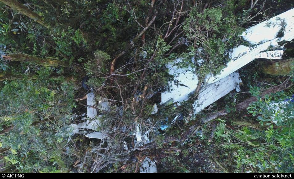
photo (c) AIC PNG; near Dinangat Village; 06 January 2018
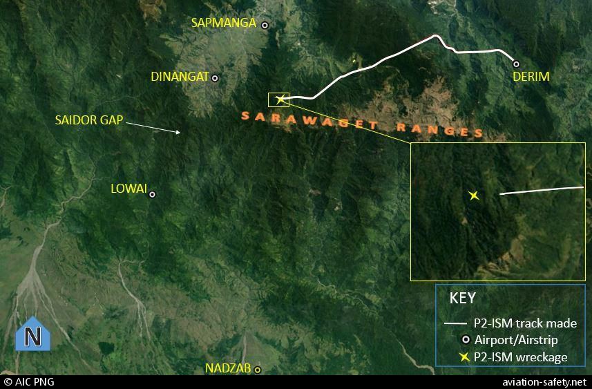
photo (c) AIC PNG; near Dinangat Village; 23 December 2017
Revision history:
| Date/time | Contributor | Updates |
|---|
The Aviation Safety Network is an exclusive service provided by:
Quick Links:
| ASN Home | Send Correction / Feedback |
| FSF Home | Disclaimer | Copyright |
| Contact Us | Privacy Policy |
| Press / Media |
 ©2024 Flight Safety Foundation