

ASN Wikibase Occurrence # 35059
This information is added by users of ASN. Neither ASN nor the Flight Safety Foundation are responsible for the completeness or correctness of this information.
If you feel this information is incomplete or incorrect, you can submit corrected information.
| Date: | Tuesday 4 August 1998 |
| Time: | 13:45 |
| Type: |  Socata TBM700 |
| Owner/operator: | Eagle Flight Center Inc |
| Registration: | N69BS |
| MSN: | 10 |
| Year of manufacture: | 1991 |
| Total airframe hrs: | 1695 hours |
| Engine model: | P&W PT6A-64 |
| Fatalities: | Fatalities: 4 / Occupants: 4 |
| Aircraft damage: | Destroyed |
| Category: | Accident |
| Location: | Spearfish/Black Hills Airport (SPF/KSPF), SD -
 United States of America United States of America
|
| Phase: | Approach |
| Nature: | Private |
| Departure airport: | Dane County Regional Airport, WI (MSN/KMSN) |
| Spearfish/Black Hills Airport, SD (SPF/KSPF) | |
| Investigating agency: | NTSB |
| Confidence Rating: |
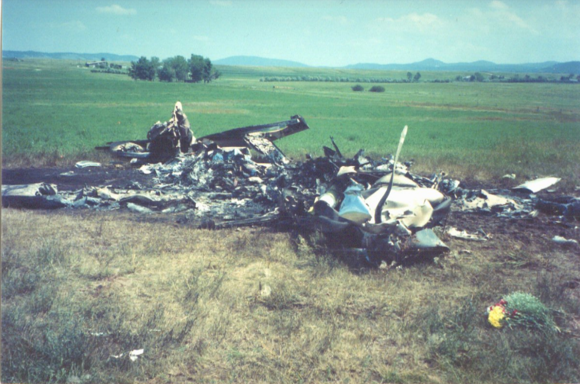
On August 4, 1998, about 1345 mountain daylight time, a Socata TBM-700, N69BS, registered to a private individual, crashed while turning from downwind to base leg at the Spearfish/Black Hills Airport (SPF) near Spearfish, South Dakota, while on a Title 14 CFR Part 91 personal flight. Marginal visual meteorological conditions were reported, and an IFR flight plan was filed. The airplane was destroyed. The private-rated pilot-in-command, a commercial-rated pilot/passenger, a private-rated pilot/passenger, and one passenger were fatally injured. The flight had originated at an unknown time, the same day, from Lawrence, Massachusetts, en route to Spearfish, and had made a refueling stop at Madison, Wisconsin. The flight departed Madison at 1146 CDT [1046 MST].
Witnesses observed the flight enter downwind for runway 30, after it had completed a published approach to runway 12, with a circle to land on runway 30. The witnesses, one of which was a commercial pilot said that there were jagged ceilings at the time about 400 to 500 feet above the ground. He and two other men with him saw the airplane below the clouds. As the airplane proceeded downwind, it momentarily entered a cloud. As the airplane came out of the cloud, it turned left in about a 30 degree turn. The angle of bank increased to about 70 to 80 degrees, the tail of the airplane came up, and the airplane impacted the ground nose first.
Several pilots at the airport heard someone from N69BS make a radio transmission on the UNICOM frequency. What was heard by several people was that N69BS had broken out at 2200 feet. They then heard, 'N69BS turning base,' immediately followed by 'lookout' and 'oh ....' All of the eye witnesses agreed that at no time did they see or hear any problems with the engine. They all said that the sounds coming from the engine never changed. The published approach in use at the time of the accident was the GPS (global positioning system) runway 12. The pilot made his initial approach to runway 12, broke off the approach to the right, entered a right downwind for a landing on runway 30. The published circling minimums for the approach were MDA (minimum descent altitude) 4,800 feet, HAT (height above terrain) 869 feet. Using an approach speed of 90 knots, the minimum visibility was 1 mile. Using an approach speed of 120 knots, the minimum visibility was 1 1/4 miles. The field elevation was 3,931 feet. The profile for the GPS runway 12 approach showed that after the IAF (Jesee way point), the course was 204 degrees, at 7,000 feet, to the Dezzi way point, from Dezzi the course was 114 degrees, descend to 5,600, to Sophi way point, after Sophi descend to 4,800 feet to the missed approach point at the Ruste way point. The distance from Dezzi to Ruste was 10 miles.
Probable Cause: The pilot's failure to maintain control of the airplane while turning to base leg. Contributing factors were low ceilings, clouds, and the pilot's failure to adhere to both the published approach procedures and the published minimum decent altitude.
Accident investigation:
 |
|
Sources:
NTSB
Images:

Photos: NTSB
Revision history:
| Date/time | Contributor | Updates |
|---|---|---|
| 24-Oct-2008 10:30 | ASN archive | Added |
| 30-Jul-2016 22:33 | Dr.John Smith | Updated [Time, Operator, Location, Departure airport, Destination airport, Source, Narrative] |
| 13-Oct-2022 11:20 | Captain Adam | Updated [Time, Location, Departure airport, Destination airport, Source, Narrative, Category, Accident report, Photo] |
| 13-Oct-2022 11:21 | Captain Adam | Updated [Photo] |
Corrections or additions? ... Edit this accident description
The Aviation Safety Network is an exclusive service provided by:
Quick Links:
| ASN Home | Send Correction / Feedback |
| FSF Home | Disclaimer | Copyright |
| Contact Us | Privacy Policy |
| Press / Media |
 ©2024 Flight Safety Foundation