

ASN Wikibase Occurrence # 351146
This information is added by users of ASN. Neither ASN nor the Flight Safety Foundation are responsible for the completeness or correctness of this information.
If you feel this information is incomplete or incorrect, you can submit corrected information.
| Date: | Tuesday 23 January 2024 |
| Time: | 18:44 |
| Type: |  Cessna 172N Skyhawk |
| Owner/operator: | Florida General Aviation opb ATA Flight School |
| Registration: | N737VC |
| MSN: | 17269700 |
| Year of manufacture: | 1977 |
| Fatalities: | Fatalities: 2 / Occupants: 2 |
| Aircraft damage: | Destroyed |
| Category: | Accident |
| Location: | near Weston, FL -
 United States of America United States of America
|
| Phase: | En route |
| Nature: | Training |
| Departure airport: | Hollywood-North Perry Airport, FL (HWO/KHWO) |
| Naples Airport, FL (APF/KAPF) | |
| Investigating agency: | NTSB |
| Confidence Rating: |
On January 23, 2024, about 1844 eastern standard time, a Cessna 172N, N737VC, was substantially damaged when it was involved in an accident near Weston, Florida. Both commercial pilots were fatally injured. The airplane was operated as a Title 14 Code of Federal Regulations Part 91 personal flight.
The airplane was owned and operated by a flight school. The owner of the flight school reported that the two pilots rented the airplane for a cross-country flight from North Perry Airport (HWO), Hollywood, Florida to Naples Municipal Airport (APF), Naples, Florida and would be returning to HWO that same evening.
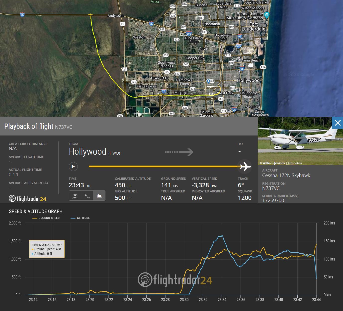
A preliminary review of Automatic Dependent Surveillance-Broadcast (ADS-B) data revealed the airplane departed runway 10R at HWO about 1830. The airplane climbed to about 1,850 ft mean sea level (msl) while making a right downwind departure from the airport. After departing controlled airspace, about 5 minutes into the flight, until about 20 seconds before track data was lost, the airplane made multiple altitude fluctuations with a maximum altitude of 1,850 ft msl and a minimum altitude of 1,000 ft msl. Twenty seconds before track data was lost the airplane was on a 353° magnetic heading at 1,300 ft msl and a ground speed of 109 knots, when the airplane subsequently began a descent. At 1844 the last track data point was recorded while the airplane was on a 007° magnetic heading at 450 ft msl and a ground speed of 143 knots.
The airplane came to rest in a swamp/marsh area with a debris path approximately 300 ft long oriented on about a 010° magnetic heading. Wreckage observations included the impact separated nose wheel, the impact-damaged nose landing gear strut, and the left-wing separated from the fuselage. The main wreckage came to rest in about 4 ft of water on a magnetic heading of about 130°. A post-accident fire consumed parts of the fuselage and right wing, while the instrument panel, firewall, and engine were located 25 ft north of the main wreckage. The fuselage was fragmented, with the aft portion mostly intact. Control continuity for the rudder, elevator, and elevator trim was confirmed, and the elevator trim actuator measurements corresponded to a 15° tab up position. The left wing exhibited aft crushing, and the left aileron and flap cables exhibited tensile overload. The right wing remained attached only by the aileron direct control cable, and the flap actuator indicated a flaps UP configuration.
The engine was impact-damaged and the lower right engine mount tubes were separated. Compression, suction, and valvetrain continuity were confirmed on all cylinders when the crankshaft was rotated. All leads from both magnetos sparked when the magnetos were rotated, and all spark plugs exhibited severe wear. The oil filter was removed, cut open, and exhibited no debris in the filter pleats. The propeller, remained attached, had both blades bent aft, and contained chordwise scratching. Both wing fuel tanks were breached, the fuel selector valve was not recovered, and organic debris was observed in the fuel strainer and carburetor screens.
The wreckage was retained for further examination.
Accident investigation:
 |
|
Sources:
https://www.local10.com/news/local/2024/01/24/broward-rescue-crews-locate-plane-crash-near-alligator-alley/
https://wsvn.com/news/local/broward/2-dead-after-plane-crashes-in-west-broward/
https://eu.naplesnews.com/story/news/local/florida/2024/01/24/florida-everglades-plane-crash-deaths/72338575007/
NTSB
https://registry.faa.gov/AircraftInquiry/Search/NNumberResult?nNumberTxt=N737VC
https://www.flightradar24.com/data/aircraft/n737vc#33ba4dad
Location
Images:
Revision history:
| Date/time | Contributor | Updates |
|---|---|---|
| 24-Jan-2024 18:36 | Captain Adam | Added |
| 24-Jan-2024 19:52 | icedragon8807 | Updated [Time, Registration, Cn] |
| 24-Jan-2024 19:56 | harro | Updated [Aircraft type, Operator, Other fatalities, Phase, Source, Photo] |
| 24-Jan-2024 20:07 | harro | Updated [Time, Other fatalities, Narrative] |
| 24-Jan-2024 21:20 | RobertMB | Updated [Time, Operator, Location, Nature, Destination airport, Source, Narrative, Category] |
| 26-Jan-2024 19:47 | Captain Adam | Updated [Location, Narrative] |
| 26-Jan-2024 23:13 | RobertMB | Updated [Location, Source, Narrative] |
| 27-Jan-2024 11:14 | Captain Adam | Updated [Location, Source, Narrative] |
| 07-Feb-2024 20:33 | Captain Adam | Updated [Time, Destination airport, Source, Narrative, Accident report] |
Corrections or additions? ... Edit this accident description
The Aviation Safety Network is an exclusive service provided by:
Quick Links:
| ASN Home | Send Correction / Feedback |
| FSF Home | Disclaimer | Copyright |
| Contact Us | Privacy Policy |
| Press / Media |
 ©2024 Flight Safety Foundation