

ASN Wikibase Occurrence # 36011
This information is added by users of ASN. Neither ASN nor the Flight Safety Foundation are responsible for the completeness or correctness of this information.
If you feel this information is incomplete or incorrect, you can submit corrected information.
| Date: | Thursday 12 December 1996 |
| Time: | 21:13 |
| Type: |  MBB Bo 105CBS |
| Owner/operator: | RTS Helicopter Services Corp opb Mercy Flight Central |
| Registration: | N90750 |
| MSN: | S-154 |
| Year of manufacture: | 1974 |
| Total airframe hrs: | 11036 hours |
| Engine model: | Allison 250-C20B |
| Fatalities: | Fatalities: 3 / Occupants: 3 |
| Aircraft damage: | Destroyed |
| Category: | Accident |
| Location: | near Penn Yan, NY -
 United States of America United States of America
|
| Phase: | En route |
| Nature: | Ambulance |
| Departure airport: | Jerusalem, NY |
| Rochester, NY | |
| Investigating agency: | NTSB |
| Confidence Rating: |
On December 12, 1996, approximately 2113 eastern standard time, a Messerschmitt-Bolkow-Blohm (MBB) BO-105CBS, N90750, was destroyed following a collision with the terrain west of Penn Yan, New York. The certificated commercial pilot, paramedic, and the patient received fatal injuries. The helicopter was owned by RTS Helicopter Services Corporation, Montvale, New Jersey; leased by EMS Air Services of New York, Inc., and operated by Mercy Flight Central, Inc., Canandaigua, New York. Night visual meteorological conditions existed and no flight plan was filed for the medical evacuation flight conducted under 14 CFR Part 135.
The pilot landed the helicopter in an open field for a medical evacuation. He had planned to fly to a hospital about 40 miles northwest. After takeoff, the pilot radioed the company dispatcher that he was airborne, and to standby for time and distance to the destination. The distance would be obtained from a GPS located on the rear of the helicopter's center console. About 2 minutes later, the helicopter crashed in a secluded wooded area on rising terrain about 1.1 miles northwest of the departure point. Witnesses reported that the cloud cover and the isolated area made a dark night with no discernable horizon. Winds were reported as strong and gusty from the south/southeast. The topography surrounding the area included rising terrain, with peaks at 2,700 feet msl. The helicopter had departed an airport with an elevation of 814 feet msl. The pick-up point was 1,540 feet msl, and the accident site was 1,740 feet msl. Cloud cover in the area was at 1,900 to 2,000 feet msl.
Probable Cause: The pilot's failure to maintain altitude/clearance from the terrain. Factors relating to the accident were: the pilot's diverted attention to the GPS, darkness, low ceiling, rising terrain, and high wind condition.
Accident investigation:
 |
|
Sources:
https://www.ntsb.gov/_layouts/ntsb.aviation/brief.asp?ev_id=20001208X07172&key=1
Images:
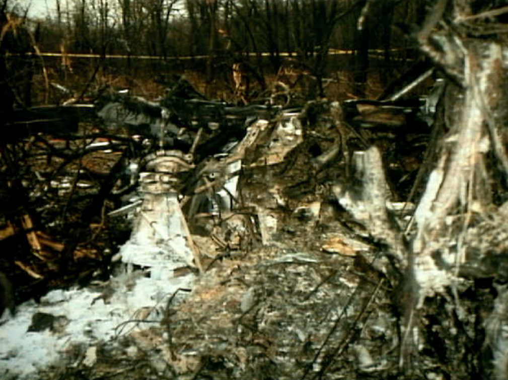
Photo: NTSB
Revision history:
| Date/time | Contributor | Updates |
|---|---|---|
| 24-Oct-2008 10:30 | ASN archive | Added |
| 02-Oct-2010 14:09 | TB | Updated [Time, Operator, Other fatalities, Nature] |
| 23-Oct-2012 12:14 | TB | Updated [Time, Operator, Location, Departure airport, Destination airport, Source, Narrative] |
| 11-Oct-2016 14:41 | TB | Updated [Source] |
| 21-Dec-2016 19:22 | ASN Update Bot | Updated [Time, Damage, Category, Investigating agency] |
| 18-Oct-2022 18:00 | Captain Adam | Updated [Operator, Location, Narrative, Accident report, Photo] |
Corrections or additions? ... Edit this accident description
The Aviation Safety Network is an exclusive service provided by:
Quick Links:
| ASN Home | Send Correction / Feedback |
| FSF Home | Disclaimer | Copyright |
| Contact Us | Privacy Policy |
| Press / Media |
 ©2024 Flight Safety Foundation