

ASN Wikibase Occurrence # 39709
This information is added by users of ASN. Neither ASN nor the Flight Safety Foundation are responsible for the completeness or correctness of this information.
If you feel this information is incomplete or incorrect, you can submit corrected information.
| Date: | Saturday 10 December 1994 |
| Time: | 19:00 |
| Type: |  Cessna 402C |
| Owner/operator: | Ryan Air Service |
| Registration: | N1238K |
| MSN: | 402C1019 |
| Year of manufacture: | 1985 |
| Total airframe hrs: | 10722 hours |
| Engine model: | CONTINENTAL TSIO-520-VB |
| Fatalities: | Fatalities: 5 / Occupants: 5 |
| Aircraft damage: | Destroyed |
| Category: | Accident |
| Location: | near Elim, AK -
 United States of America United States of America
|
| Phase: | En route |
| Nature: | Passenger - Non-Scheduled/charter/Air Taxi |
| Departure airport: | Nome Airport, AK (OME) |
| Koyuk-Alfred Adams Airport, AK (KKA) | |
| Investigating agency: | NTSB |
| Confidence Rating: |
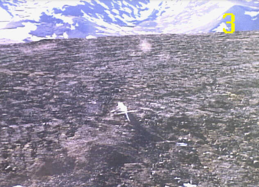
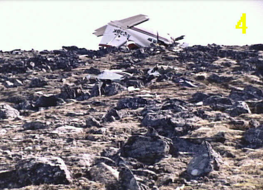
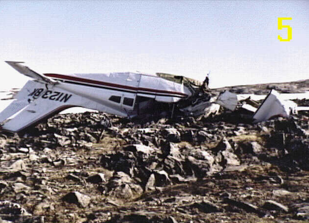
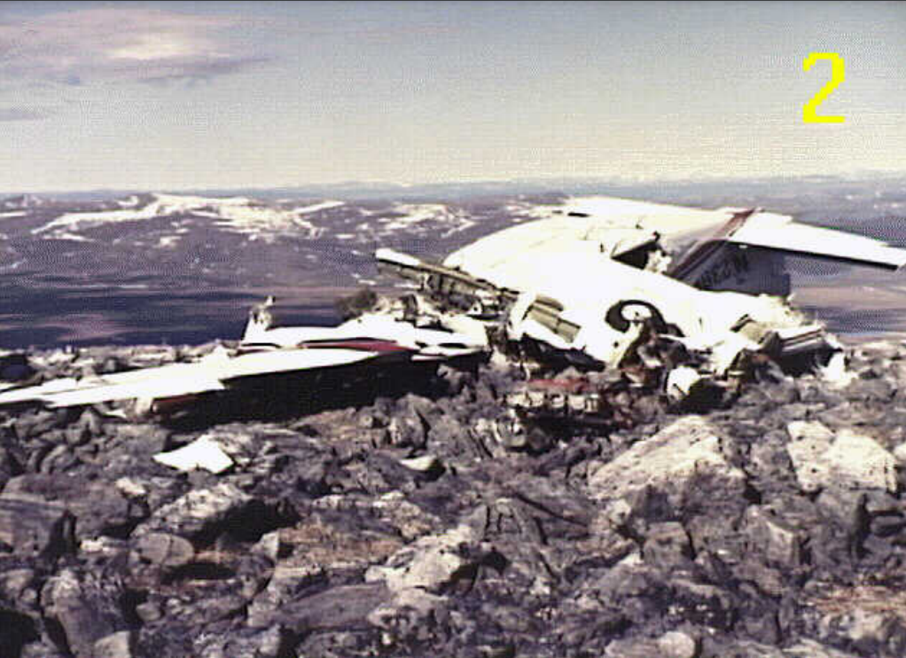
On December 10, 1994, at 1900 Alaska standard time, a retractable gear, wheel equipped Cessna 402C, N1238K, registered to and operated by Ryan Air Service of Anchorage, Alaska, crashed into a mountain located approximately 12 miles northwest of Elim, Alaska. The scheduled air taxi flight, operating under 14 CFR Part 135 as Ryan Air Flight 2402, departed Nome, Alaska, on a route that would have taken the flight to Koyuk, Shaktoolik, and a return to Nome. The flight did not reach the first destination. A Federal Aviation Administration (FAA) flight plan was not filed but a company flight plan was in effect. Instrument meteorological conditions prevailed at the accident site. The airline transport certificated pilot and the four passengers were fatally injured and the airplane was destroyed by impact forces.
THE AIRPLANE WAS ON A FLIGHT AT NIGHT FROM NOME TO KOYUK, AK, WHEN IT CRASHED INTO A MOUNTAIN AT THE 2725 FOOT LEVEL. THE ACCIDENT SITE WAS DIRECTLY ON A COURSE LINE BETWEEN THE NOME AND KOYUK AIRPORTS. THE CEILING AT NOME WAS 3500 OVERCAST AT THE TIME OF DEPARTURE. ACCORDING TO RESCUE PERSONNEL, WEATHER AT THE ACCIDENT AREA WAS: INDEFINABLE CEILING AND POOR VISIBILITY WITH HEAVY SNOW AND BLOWING SNOW. THE PILOT HAD A HAND HELD GPS ON BOARD THAT HE HAD BARROWED FROM ANOTHER PILOT. BUT THE DATABASE COULD NOT BE RETRIEVED FROM THE GPS. ACCORDING TO THE OWNER OF THE GPS, HE AND THE ACCIDENT PILOT PROGRAMMED DIFFERENT WAYPOINTS. THE PILOT DID NOT FILE A VFR OR AN IFR FLIGHT PLAN WITH THE FAA.
Probable Cause: VFR FLIGHT BY THE PILOT INTO INSTRUMENT METEOROLOGICAL CONDITIONS (IMC), AND HIS FAILURE TO MAINTAIN SUFFICIENT ALTITUDE OR CLEARANCE FROM MOUNTAINOUS TERRAIN. FACTORS RELATED TO THE ACCIDENT WERE: DARKNESS AND THE ADVERSE WEATHER CONDITIONS.
Accident investigation:
 |
|
Sources:
NTSB: https://www.ntsb.gov/ntsb/brief.asp?ev_id=20001206X02666
Images:
Photos: NTSB
Revision history:
| Date/time | Contributor | Updates |
|---|---|---|
| 24-Oct-2008 10:30 | ASN archive | Added |
| 21-Dec-2016 19:23 | ASN Update Bot | Updated [Time, Damage, Category, Investigating agency] |
| 11-Oct-2022 22:42 | Captain Adam | Updated [Location, Nature, Departure airport, Destination airport, Narrative, Category, Accident report, Photo] |
| 11-Oct-2022 22:43 | Captain Adam | Updated [Photo] |
| 11-Oct-2022 22:43 | Captain Adam | Updated [Photo] |
| 11-Oct-2022 22:44 | Captain Adam | Updated [Photo] |
Corrections or additions? ... Edit this accident description
The Aviation Safety Network is an exclusive service provided by:
Quick Links:
| ASN Home | Send Correction / Feedback |
| FSF Home | Disclaimer | Copyright |
| Contact Us | Privacy Policy |
| Press / Media |
 ©2024 Flight Safety Foundation