

ASN Wikibase Occurrence # 42883
This information is added by users of ASN. Neither ASN nor the Flight Safety Foundation are responsible for the completeness or correctness of this information.
If you feel this information is incomplete or incorrect, you can submit corrected information.
| Date: | Friday 17 June 1994 |
| Time: | 10:55 |
| Type: |  Beechcraft A36 Bonanza |
| Owner/operator: | private |
| Registration: | N1525G |
| MSN: | E-2462 |
| Year of manufacture: | 1988 |
| Total airframe hrs: | 1260 hours |
| Engine model: | CONTINENTAL IO-550-B(6) |
| Fatalities: | Fatalities: 3 / Occupants: 4 |
| Aircraft damage: | Destroyed |
| Category: | Accident |
| Location: | Brainerd, MN -
 United States of America United States of America
|
| Phase: | Approach |
| Nature: | Private |
| Departure airport: | Lincoln Airport, NE (LNK) |
| Brainerd Lakes Regional Airport, MN (BRD/KBRD) | |
| Investigating agency: | NTSB |
| Confidence Rating: |
On June 17, 1994, about 1055 central daylight time, a Beech A-36, N1525G, operated by the owner/pilot, impacted terrain in Brainerd, Minnesota, during a missed approach to runway 23. The airplane was destroyed. The certificated private pilot and two passengers were fatally injured. The remaining passenger was seriously injured. Instrument meteorological conditions prevailed and an instrument flight rules (IFR) flight plan was filed. The personal flight departed from Lincoln, Nebraska, at 0825 and was en route to Brainerd. The flight was conducted under 14 CFR 91.
THE AIRPLANE WAS ON AN IFR FLIGHT PLAN. PRIOR TO THE APPROACH, THE PILOT TOLD ATC THAT HE 'NEEDED ALL THE HELP I CAN GET. I'M KIND OF NEW AT THIS.' HE WAS THEN CLEARED TO DESCEND AND BEGAN RECEIVING RADAR VECTORS FOR THE ILS APPROACH. THE AIRPLANE BEGAN TO HEAD TOWARDS A NEARBY VOR AFTER BEING VECTORED TO THE LOCALIZER COURSE. THE PILOT RADIOED THAT HE WAS NOT ON THE LOCALIZER AND REQUESTED ASSISTANCE. ATC PROVIDED ANOTHER VECTOR AND CLEARED THE AIRPLANE FOR THE APPROACH. THE AIRPLANE INTERCEPTED THE LOCALIZER AND THEN DISAPPEARED FROM RADAR. RADIO COMMUNICATION WAS LOST AFTER THE PILOT DECLARED A MISSED APPROACH. THE AIRPLANE IMPACTED TERRAIN SOUTH OF THE AIRPORT. THE PILOT HAD RECEIVED HIS INSTRUMENT RATING 6 MONTHS BEFORE THE ACCIDENT. SEVERAL PROCEDURES SPECIFIED IN THE ATC HANDBOOK WERE NOT FOLLOWED BY THE CONTROLLER. AFTER THE PILOT INITIALLY BEGAN TO STRAY FROM THE LOCALIZER COURSE, HE WAS NOT INFORMED OF HIS POSITION RELATIVE TO THE LOCALIZER, NOR WAS AN INQUIRY MADE AS TO THE PILOT'S INTENTIONS. IN ADDITION, THE VECTOR PROVIDED TO INTERCEPT THE LOCALIZER COURSE RESULTED IN AN INTERCEPT ANGLE OF 40 DEG; THE ATC HANDBOOK STIPULATES A MAXIMUM INTERCEPT ANGLE OF 30 DEG.
Probable Cause: THE PILOT'S FAILURE TO FOLLOW THE PUBLISHED MISSED APPROACH PROCEDURE, AND HIS FAILURE TO OBTAIN AND/OR MAINTAIN ADEQUATE ALTITUDE TO AVOID COLLISION WITH THE TERRAIN. FACTORS IN THE ACCIDENT WERE: THE PILOT'S LACK OF INSTRUMENT FLYING EXPERIENCE, AND THE CONTROLLER'S FAILURE TO FOLLOW STANDARD PROCEDURES AND TO PROVIDE MORE COMPLETE AND HELPFUL GUIDANCE TO THE INEXPERIENCED PILOT DURING THE APPROACH.
Accident investigation:
 |
|
Sources:
NTSB: http://www.ntsb.gov/ntsb/brief.asp?ev_id=20001206X01446
History of this aircraft
Other occurrences involving this aircraft
| 22 May 2010 | N36GG | Craig and Lucy Davisson Partnership | 2300 block of 120th Street about 10 miles north of Winterset, IA | |
min |
Images:
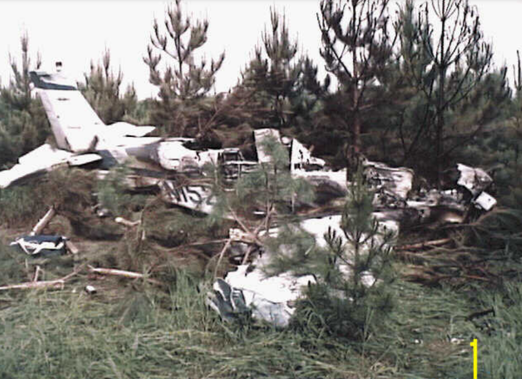
Photo: NTSB
Revision history:
| Date/time | Contributor | Updates |
|---|---|---|
| 24-Oct-2008 10:30 | ASN archive | Added |
| 21-Dec-2016 19:24 | ASN Update Bot | Updated [Time, Damage, Category, Investigating agency] |
| 12-Oct-2022 03:28 | Captain Adam | Updated [Departure airport, Destination airport, Narrative, Accident report, Photo] |
Corrections or additions? ... Edit this accident description
The Aviation Safety Network is an exclusive service provided by:
Quick Links:
| ASN Home | Send Correction / Feedback |
| FSF Home | Disclaimer | Copyright |
| Contact Us | Privacy Policy |
| Press / Media |
 ©2024 Flight Safety Foundation