

ASN Wikibase Occurrence # 43311
This information is added by users of ASN. Neither ASN nor the Flight Safety Foundation are responsible for the completeness or correctness of this information.
If you feel this information is incomplete or incorrect, you can submit corrected information.
| Date: | Saturday 12 June 1999 |
| Time: | 17:35 |
| Type: |  Cessna 182R Skylane |
| Owner/operator: | Civil Air Patrol |
| Registration: | N9458H |
| MSN: | 18267953 |
| Year of manufacture: | 1981 |
| Total airframe hrs: | 2064 hours |
| Engine model: | Continental O-470-U |
| Fatalities: | Fatalities: 2 / Occupants: 2 |
| Aircraft damage: | Destroyed |
| Category: | Accident |
| Location: | Enterprise, OR -
 United States of America United States of America
|
| Phase: | Manoeuvring (airshow, firefighting, ag.ops.) |
| Nature: | Training |
| Departure airport: | Baker City Municipal Airport, OR (BKE) |
| Baker City Municipal Airport, OR (BKE) | |
| Investigating agency: | NTSB |
| Confidence Rating: |
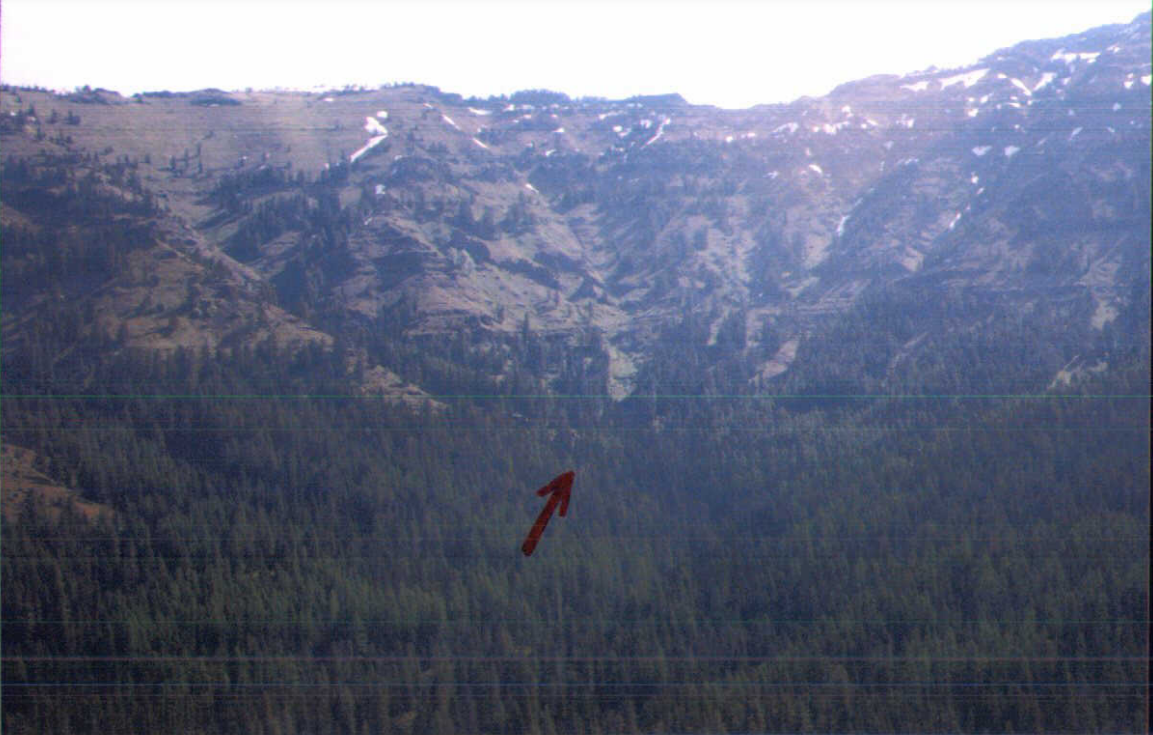
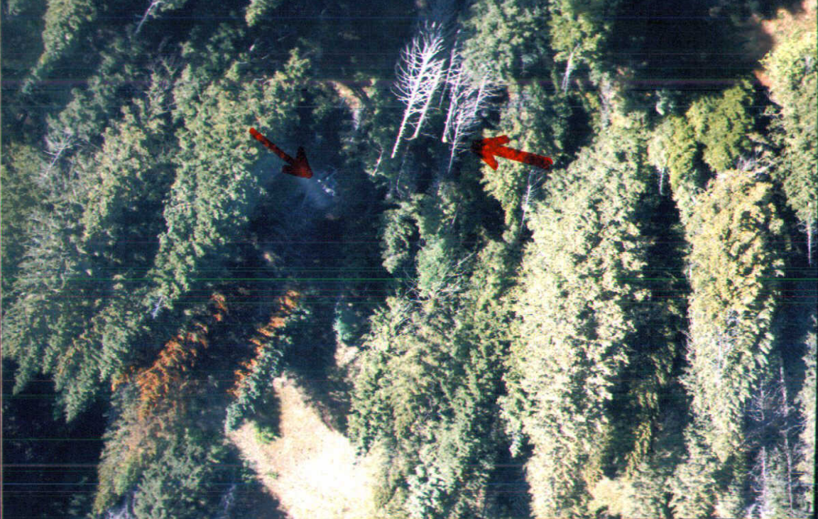
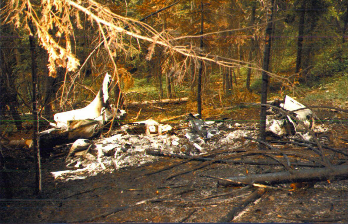
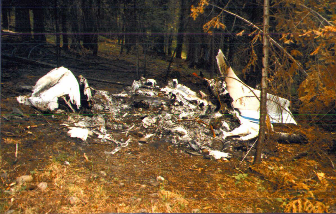
On June 12, 1999, approximately 1635 Pacific daylight time, N9458H, a Cessna 182R airplane registered to Civil Air Patrol (CAP) Inc. of Montgomery, Alabama, and operated by the Oregon Wing of the CAP as a public-use mountain search-and-rescue (SAR) training flight, departed Baker City, Oregon, on a scheduled 1.5-hour mission. The aircraft failed to return to Baker City at the scheduled time, and a search for the aircraft was initiated. The aircraft wreckage was located on June 14, 1999, in the Chaparral Creek canyon in the Eagle Cap Wilderness of the Wallowa-Whitman National Forest, approximately 12 nautical miles west-southwest of Enterprise, Oregon. The aircraft was found to be destroyed by impact forces and fire, and both aircraft occupants, consisting of a commercial pilot-in-command and an additional commercial pilot acting in the capacity of a mountain flying "mentor", were found fatally injured. Visual meteorological conditions were reported at Baker City and La Grande, Oregon, during the scheduled time frame of the accident flight, and a company visual flight rules (VFR) flight plan had been filed. There was no report of an emergency locator transmitter (ELT) activation.
The flight was part of a U.S. Air Force-sponsored mountain flying training clinic. The planned flight route included a contour search pattern into a series of drainages along the Minam River valley, including the canyon in which the accident occurred. A trainee at the clinic who flew the accident flight route with the accident flight 'mentor' on the accident aircraft's previous flight reported that he had refused to fly into most of the drainages on the route, believing that the aircraft did not have sufficient climb capability or space to turn around in the drainages. This trainee reported that the route segment where the accident occurred was flown at 90 knots with 10 degrees of flaps. When the accident flight failed to return to base at the scheduled time and contact could not be established with the aircraft, a search was begun. The aircraft wreckage was located approximately two days later, with both occupants found fatally injured at the accident site. A chart of the planned flight route showed that at the approximate location of the crash site, a 135-degree turn was to be made to climb out, exit the training route and return to base. The accident site, located at the 5,400-foot level on sloping terrain, was approximately 1/2 mile beyond the depicted turn point (i.e., further into the canyon than planned.) Investigators found damage and impact signatures at the accident site consistent with an uncontrolled, relatively low-speed impact with the terrain, and the aircraft's flaps at 10 to 15 degrees, but no evidence of pre-impact mechanical problems with the aircraft. Based on a METAR observation taken about the estimated time the crash occurred, density altitude at La Grande, Oregon (approximately 19 nautical miles from, and 2,700 feet below the accident site) was computed to be approximately 5,000 feet.
Probable Cause: The pilot's failure to maintain aircraft control while maneuvering in a canyon, and the mentor's failure to take adequate remedial action. Factors included box canyon terrain and high density altitude conditions.
Accident investigation:
 |
|
Sources:
NTSB: https://www.ntsb.gov/_layouts/ntsb.aviation/brief.aspx?ev_id=20001212X19110&key=1
Images:

Photos: NTSB
Revision history:
| Date/time | Contributor | Updates |
|---|---|---|
| 24-Oct-2008 10:30 | ASN archive | Added |
| 21-Dec-2016 19:24 | ASN Update Bot | Updated [Time, Damage, Category, Investigating agency] |
| 14-Dec-2017 08:27 | ASN Update Bot | Updated [Operator, Nature, Source, Narrative] |
| 13-Oct-2022 06:34 | Captain Adam | Updated [Aircraft type, Operator, Nature, Departure airport, Destination airport, Narrative, Accident report, Photo] |
| 13-Oct-2022 06:34 | Captain Adam | Updated [Photo] |
| 13-Oct-2022 06:34 | Captain Adam | Updated [Photo] |
| 13-Oct-2022 06:35 | Captain Adam | Updated [Photo] |
| 13-Oct-2022 06:35 | Captain Adam | Updated [Photo] |
| 31-May-2023 19:55 | Ron Averes | Updated [[Photo]] |
Corrections or additions? ... Edit this accident description
The Aviation Safety Network is an exclusive service provided by:
Quick Links:
| ASN Home | Send Correction / Feedback |
| FSF Home | Disclaimer | Copyright |
| Contact Us | Privacy Policy |
| Press / Media |
 ©2024 Flight Safety Foundation