

ASN Wikibase Occurrence # 43612
This information is added by users of ASN. Neither ASN nor the Flight Safety Foundation are responsible for the completeness or correctness of this information.
If you feel this information is incomplete or incorrect, you can submit corrected information.
| Date: | Saturday 2 February 2008 |
| Time: | 13:40 |
| Type: |  Cessna 340A |
| Owner/operator: | Private |
| Registration: | N354TJ |
| MSN: | 340A0042 |
| Engine model: | Teledyne Continental TSIO-520 SER |
| Fatalities: | Fatalities: 4 / Occupants: 4 |
| Aircraft damage: | Destroyed |
| Category: | Accident |
| Location: | Cabezon, CA -
 United States of America United States of America
|
| Phase: | Manoeuvring (airshow, firefighting, ag.ops.) |
| Nature: | Private |
| Departure airport: | Palm Springs, CA (UDD) |
| Chino, CA (CNO) | |
| Investigating agency: | NTSB |
| Confidence Rating: |
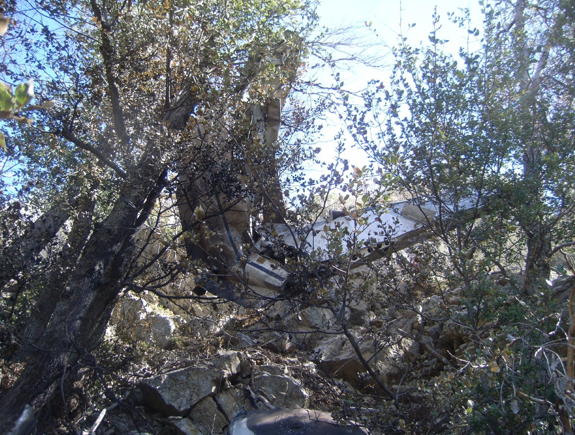
The airplane departed under daytime visual meteorological conditions on a cross-country flight from an airport on the east side of a mountain range to a destination on the west side of the mountains. The airplane, which had been receiving flight following, then collided with upsloping mountainous terrain in a mountain pass while in controlled flight after encountering instrument meteorological conditions. The controller terminated radar services due to anticipation of losing radar coverage within the mountainous pass area, and notified the pilot to contact the next sector once through the pass while staying northwest of an interstate highway due to opposing traffic on the south side of the highway. The pilot later contacted the controller asking if he still needed to remain on a northwesterly heading. The controller replied that he never assigned a northwesterly heading. No further radio communications were received from the accident airplane. Radar data revealed that while proceeding on a northeasterly course, the airplane climbed to an altitude of 6,400 feet mean sea level (msl). A few minutes later, the radar data showed the airplane turning to an easterly heading and initiating a climb to an altitude of 6,900 feet msl. The airplane then started descending in a right turn from 6,900 feet to 5,800 feet msl prior to it being lost from radar contact about 0.65 miles southeast of the accident site. A weather observation station located at the departure airport reported a scattered cloud layer at 10,000 feet above ground level (agl). A weather observation system located about 29 miles southwest of the accident site reported a broken cloud layer at 4,000 feet agl. A pilot, who was flying west bound at 8,500 feet through the same pass around the time of the accident, reported overcast cloud coverage in the area of the accident site that extended west of the mountains. The pilot stated that the ceiling was around 4,000 feet msl and the tops of the clouds were 7,000 feet msl or higher throughout the area. Postaccident examination of the airframe and both engines revealed no anomalies that would have precluded normal operation.
Probable Cause: The pilot's continued visual flight into instrument meteorological conditions and failure to maintain terrain clearance while en route. Contributing to the accident were clouds and mountainous terrain.
Accident investigation:
 |
|
Sources:
NTSB
Location
Images:
(c) NTSB

(c) NTSB
Revision history:
| Date/time | Contributor | Updates |
|---|---|---|
| 28-Oct-2008 00:45 | ASN archive | Added |
| 23-Jun-2009 12:17 | harro | Updated |
| 23-Jun-2009 12:18 | harro | Updated |
| 25-Jun-2009 00:15 | RobertMB | Updated |
| 21-Dec-2016 19:24 | ASN Update Bot | Updated [Time, Damage, Category, Investigating agency] |
| 03-Dec-2017 09:35 | ASN Update Bot | Updated [Operator, Other fatalities, Source, Narrative] |
Corrections or additions? ... Edit this accident description
The Aviation Safety Network is an exclusive service provided by:
Quick Links:
| ASN Home | Send Correction / Feedback |
| FSF Home | Disclaimer | Copyright |
| Contact Us | Privacy Policy |
| Press / Media |
 ©2024 Flight Safety Foundation