

ASN Wikibase Occurrence # 44664
This information is added by users of ASN. Neither ASN nor the Flight Safety Foundation are responsible for the completeness or correctness of this information.
If you feel this information is incomplete or incorrect, you can submit corrected information.
| Date: | Wednesday 20 October 2004 |
| Time: | 00:43 |
| Type: |  MBB Bo 105CBS-5 |
| Owner/operator: | Metro Aviation Inc |
| Registration: | N916SH |
| MSN: | S-769 |
| Year of manufacture: | 1988 |
| Total airframe hrs: | 8846 hours |
| Engine model: | Allison 250-C20B |
| Fatalities: | Fatalities: 3 / Occupants: 3 |
| Aircraft damage: | Destroyed |
| Category: | Accident |
| Location: | Choctawhatchee Bay, near Santa Rosa Beach, FL -
 United States of America United States of America
|
| Phase: | En route |
| Nature: | Ferry/positioning |
| Departure airport: | Santa Rosa Beach, FL |
| DeFuniak Springs, FL | |
| Investigating agency: | NTSB |
| Confidence Rating: |
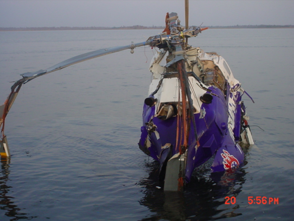
On October 20, 2004, about 0043 central daylight time, a Eurocopter Deutschland BO-105 CBS5, N916SH, call sign Airheart One, registered to and operated by Metro Aviation, Inc., as a Title 14 CFR Part 91 emergency medical services (EMS) positioning flight, from Santa Rosa Beach, Florida, to DeFuniak Springs, Florida, crashed in Choctawhatchee Bay, near Santa Rosa Beach. Instrument meteorological conditions prevailed in the accident area at the time and a company visual flight rules flight plan was filed. The helicopter was destroyed and the commercial-rated pilot, paramedic, and flight nurse were fatally injured. The flight originated from Santa Rosa Beach at 0041.
The emergency medical services (EMS) airplane was on a positioning flight when it crashed in instrument conditions in the Choctawatchee Bay. Personnel from the Walton County, Florida, Emergency Operations Center, stated that at 0021 they received a call from a hospital in DeFuniak Springs, requesting the Airheart One helicopter to transport a patient to Pensacola, Florida. The dispatcher then contacted the pilot of Airheart One and advised him of the request. The pilot stated he would have to check the weather and get back to him. At 0035, the pilot called back and stated they would take the flight. At 0041, the paramedic on Airheart One called via radio and reported they were airborne with three persons on board, 2 hours 20 minutes of fuel, and an estimated time en route to the hospital of 10 minutes. At 0043, the paramedic reported that due to weather they were returning to base. The dispatcher did not talk with the flight after this. At 0050, the dispatcher cleared the Airheart One call, believing that they were back at base due to the short flight time. At 0610, the relief pilot that was coming on duty called the Emergency Operations Center and advised that Airheart One was not at base. Search and rescue operations were initiated and the wreckage of the helicopter was located in Choctawhatchee Bay about 0820. A witness, who was fishing on the northwest side of the Highway 331 bridge reported that between 0030 and 0100, he observed a helicopter flying from south to north parallel to the bridge on the east side. The weather was lightning and thunder and it was just starting to drizzle and rain. He observed the helicopter either fly into a big cloud or fly behind the big cloud. He then saw lightning. He then saw the helicopter making a "U Turn" toward the east and then descend at a 45-degree angle to the water. He observed the helicopter by the red light on the belly. He left shortly after this because of the rain. Recorded radar data from Eglin Air Force Base showed that the flight departed the Walton County Sheriff's Department heliport and was first observed on radar at 0040:37 while at 300 feet, 1/10 of a mile east-southeast of the heliport. The flight climbed to 900 feet, while proceeding north bound, across the bay, flying parallel to Highway 331 Bridge. The flight then descended to between 700 and 800 feet. At 0042:18, the flight initiated a turn to the east and at 0042:49, the last radar contact was recorded when the flight was at 700 feet, flying on an east-southeast heading. This position was about 3/4 mile to the east-northeast of the crash site. The 2353 Destin-Ft. Walton Beach Airport, automated surface weather observation was visibility 7 statute miles, ceiling 800 feet broken with remarks lightning distant north, ceiling 700 variable 1300. The airport is located 16.2 nautical miles west of the accident site. The Destin 0053 weather was visibility 7 statute miles, ceiling 600 feet broken, 1,500 feet overcast., remarks lightning distant southeast. The 2355 surface weather observation taken at the Valparaiso/Okaloosa-Eglin AFB was visibility 7 statute, clouds 800 feet scattered, ceiling 2,000 feet overcast with thunderstorm, remarks thunderstorm northeast and east moving southeast. The airport is located 20 nautical miles west-northwest of the accident site. Weather radar data obtained from the Eglin AFB Doppler Weather Radar System show that weak weather echoes were present in the area of the accident at the time of the accident. Additionally, an intense to extreme weather echo was present about 10 nautical miles north of the accident site. At the time of the accident Airmet IFR MIAS WA 200145 was in effect for the accident area. The Airmet called for occasional ceilings below 1,000 feet, visibility below 3 miles, precipitation, mist, and fog. The Airmet was issued at 2045 on October 19, 2004, and was valid until 0300 on October 20, 2004. The helicopter operator's operations manual states that the pilot-in-command is responsible for obtaining a weather briefing. The manual establishes weather minimums for night visual flight rules EMS helicopter operations. The minimums are visual ground light reference, enough to properly control the helicopter, and for local flights within 30 nautical miles of base the cloud ceiling should be a minimum of 800 feet agl and visibility greater than 2 miles. For preflight planning the cloud ceiling should be 1,000 feet agl and visibility should be 3 miles. Metro Aviation, Inc. uses a commercial, computer based, weather service at the Santa Rosa Beach base. The system was online at the time of the accident and received data 6 hours before and 6 hours after the accident. The radar and text data on the system was current and the system had been used to check weather throughout the day of the accident. The exact weather products accessed by the accident pilot could not be identified. Post crash examination of the helicopter showed no evidence of precrash mechanical failure or malfunction of the helicopter structure, flight control system, electrical system, hydraulic system, main rotor system and transmission, tail rotor system, and powerplants and drive shafts. There was no evidence of lightning strike on the helicopter. Postmortem examination of the pilot and 2 medical crewmembers and testing of toxicology samples showed no evidence that could be considered causal to the accident.
Probable Cause: The pilot's spatial disorientation and in-flight loss of control of the helicopter after encountering night instrument meteorological conditions resulting in collision with water during the resultant uncontrolled descent. A factor in the accident was the pilot's decision to attempt the flight when instrument meteorological conditions were forecasted for the area.
Accident investigation:
 |
|
Sources:
NTSB: https://www.ntsb.gov/_layouts/ntsb.aviation/brief.aspx?ev_id=20041025X01691&key=1
Location
Images:

Photos: NTSB
Revision history:
| Date/time | Contributor | Updates |
|---|---|---|
| 28-Oct-2008 00:45 | ASN archive | Added |
| 07-Feb-2009 10:22 | harro | Updated |
| 27-Oct-2012 11:13 | TB | Updated [Time, Location, Departure airport, Destination airport, Source, Narrative] |
| 10-Oct-2016 17:32 | TB | Updated [Source] |
| 21-Dec-2016 19:24 | ASN Update Bot | Updated [Time, Damage, Category, Investigating agency] |
| 07-Dec-2017 18:27 | ASN Update Bot | Updated [Operator, Nature, Departure airport, Destination airport, Source, Narrative] |
Corrections or additions? ... Edit this accident description
The Aviation Safety Network is an exclusive service provided by:
Quick Links:
| ASN Home | Send Correction / Feedback |
| FSF Home | Disclaimer | Copyright |
| Contact Us | Privacy Policy |
| Press / Media |
 ©2024 Flight Safety Foundation