

ASN Wikibase Occurrence # 44887
This information is added by users of ASN. Neither ASN nor the Flight Safety Foundation are responsible for the completeness or correctness of this information.
If you feel this information is incomplete or incorrect, you can submit corrected information.
| Date: | Monday 12 April 2004 |
| Time: | 10:08 |
| Type: |  Cessna 182S Skylane |
| Owner/operator: | Private |
| Registration: | N364ME |
| MSN: | 18280853 |
| Year of manufacture: | 2000 |
| Total airframe hrs: | 387 hours |
| Engine model: | Lycoming IO-540-AB1A5 |
| Fatalities: | Fatalities: 3 / Occupants: 3 |
| Aircraft damage: | Substantial |
| Category: | Accident |
| Location: | North Augusta, SC -
 United States of America United States of America
|
| Phase: | En route |
| Nature: | Private |
| Departure airport: | Aiken Municipal Airport, SC (AIK/KAIK) |
| Greenville Airport, MS (GLH/KGLH) | |
| Investigating agency: | NTSB |
| Confidence Rating: |
On April 12, 2004, at 1008 eastern daylight time, a Cessna 182S, N364ME, registered to and operated by the private pilot, collided with trees and the ground in North Augusta, South Carolina. The personal flight was operated under the provisions of Title 14 CFR Part 91 with an instrument flight rules (IFR) plan filed. Instrument meteorological conditions prevailed. The private pilot and two passengers received fatal injuries, and the airplane sustained substantial damage. The flight departed Aiken Municipal Airport in Aiken, South Carolina, at 0939 on April 12, 2004.
The flight departed on an IFR flight plan, did not proceed on its northwest course as directed, and did not maintain a consistent heading or altitude. The flight continued in a southwest direction, and the pilot elected to land the airplane. An air traffic controller provided altitude and heading assignments for a surveillance approach, and the pilot did not maintain the assigned headings and altitudes. The controller stated to the pilot the low altitude alert indicated 600 feet, and he instructed the pilot to climb. A witness on the ground saw the airplane flying erratically beneath the clouds at treetop height, then it dipped right then left and nosed down into trees and the ground. Examination of the airframe, engine, and components revealed no evidence of mechanical malfunction. A review of the pilot's log book revealed he logged 13.9 hours actual instrument time and 102.4 hours simulated instrument time. A witness at the departure airport stated the pilot checked the weather, and he overheard the pilot "talking about flying south to avoid rain, and then heading west from there." A review of WSR-88D Doppler Weather Radar Level III images revealed an area of precipitation was approximately 10 miles west of the departure airport and extended approximately 20 miles from north to south; the location of the accident site corresponded with the southeast edge of the precipitation area. An instrument-rated pilot who was monitoring the air traffic control frequencies as the accident flight was being vectored for the approach at Augusta Regional at Bush Field stated he heard the pilot state on the radio he was trying to fly through holes in the clouds.
Probable Cause: The pilot's failure to maintain control of the airplane due to spatial disorientation, which resulted in an uncontrolled descent and subsequent in-flight collision with trees and the ground.
Accident investigation:
 |
|
Sources:
NTSB: https://www.ntsb.gov/_layouts/ntsb.aviation/brief.aspx?ev_id=20040415X00468&key=1
Location
Images:
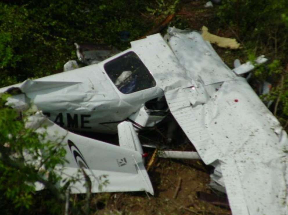
Photo: NTSB
Revision history:
| Date/time | Contributor | Updates |
|---|---|---|
| 28-Oct-2008 00:45 | ASN archive | Added |
| 21-Dec-2016 19:24 | ASN Update Bot | Updated [Time, Damage, Category, Investigating agency] |
| 07-Dec-2017 17:53 | ASN Update Bot | Updated [Source, Narrative] |
Corrections or additions? ... Edit this accident description
The Aviation Safety Network is an exclusive service provided by:
Quick Links:
| ASN Home | Send Correction / Feedback |
| FSF Home | Disclaimer | Copyright |
| Contact Us | Privacy Policy |
| Press / Media |
 ©2024 Flight Safety Foundation