

ASN Wikibase Occurrence # 45306
This information is added by users of ASN. Neither ASN nor the Flight Safety Foundation are responsible for the completeness or correctness of this information.
If you feel this information is incomplete or incorrect, you can submit corrected information.
| Date: | Thursday 23 January 2003 |
| Time: | 16:53 |
| Type: |  Cirrus SR20 |
| Owner/operator: | Private |
| Registration: | N893MK |
| MSN: | 1038 |
| Year of manufacture: | 2000 |
| Total airframe hrs: | 369 hours |
| Engine model: | Teledyne Continental IO-360-ES 6B |
| Fatalities: | Fatalities: 1 / Occupants: 1 |
| Aircraft damage: | Destroyed |
| Category: | Accident |
| Location: | San Jose, CA -
 United States of America United States of America
|
| Phase: | Approach |
| Nature: | Private |
| Departure airport: | Napa County Airport, CA (APC/KAPC) |
| San Jose-Reid-Hillview Airport, CA (RHV/KRHV) | |
| Investigating agency: | NTSB |
| Confidence Rating: |
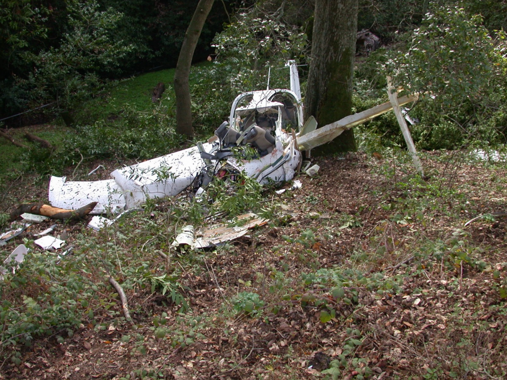
On January 23, 2002, at 1653, Pacific standard time, a Cirrus SR 20, N893MK, collided with power lines near San Jose, California. The private pilot/owner was operating the airplane under the provisions of 14 CFR Part 91. The airplane was destroyed. The pilot, the sole occupant, sustained fatal injuries. The personal cross-country flight departed Napa County Airport (APC), Napa, California, at 1600, en route to Reid-Hillview Airport of Santa Clara County (RHV), San Jose. Day instrument meteorological conditions prevailed, and an instrument flight rules (IFR) flight plan had been filed. The primary wreckage was located at 37 degrees 16 minutes north latitude and 121 degrees 43 minutes west longitude.
The airplane collided with high-tension power lines in a mountainous area after deviating from the GPS approach procedure in instrument conditions. The airplane was equipped with a GPS navigation system incorporating a moving map feature. During the initial portions of the flight after departure, the TRACON sector controller working the flight initially believed the airplane was destined to another airport and issued a clearance accordingly, but corrected the clearance after the pilot questioned the controller. Shortly after this discussion, the pilot significantly deviated from his cleared course for unknown reasons in the general direction of the mistaken airport. The controller noticed the deviation and corrected the pilot's course. A second controller in the next sector the airplane would be worked by overheard the course correction, and inferred the pilot was somewhat confused. After handoff by the first controller, the second sector controller attempted to provide what he believed was a helpful method of handling the airplane in the transition to the GPS approach; however, these methods of clearing the pilot for the GPS approach were not in strict accordance with FAA Order 7110.65, and included an intercept angle with the final approach course that was greater than allowed. The airplane was on a modified downwind and proceeding to the initial approach fix (IAF) when the controller cleared the pilot to turn toward an intermediate fix between the IAF and the final approach fix (FAF) with the idea in mind that this course would be the same as a radar vector to the FAF. The pilot questioned the clearance, and then acknowledged it, and the airplane turned left toward the FAF, which was directly behind the airplane. The controller noticed that the left turn put the airplane heading toward high terrain and advised the pilot to turn right to go to the intermediate fix. After some additional confusion the airplane's track stabilized on the approach course after passing the intermediate fix. As the airplane passed the FAF the controller told the pilot to contact the tower, but gave him the frequency for the wrong airport. The pilot questioned the controller, who insisted the frequency was correct. The pilot then contacted the second airport tower and was told he was on the wrong frequency. Almost 1 minute elapsed between the pilot's acknowledgement of the erroneous frequency, and his initial contact to the correct tower. During this period the airplane's heading diverged approximately 90 degrees from the published final approach course toward rising terrain and the accident site. The Minimum Safe Altitude Warning alarms went off in the TRACON and in the tower, and the tower controller provided a low altitude safety alert based on the alarm by saying "check your altitude immediately;" however, at the time of the low altitude alert, the airplane was about 500 feet above the Minimum Descent Altitude (the accident site elevation was about 200 feet above the MDA.) and the alert was activated not because the airplane's altitude was below the segment minimums but due to the course and altitude being projected to come in contact with terrain in the near future. This may have confused the pilot and decreased the perceived urgency. The limitations of the radar display effectively masked the initial portions of the course deviation and the controller did not see the deviation for some 30 seconds; however, the controller did advise the pilot that he was off course as soon as he was aware of it. The pilot's unintelligible response was about the time the radar target return went into coast mode.
Probable Cause: The pilot's failure to maintain the course for the published approach procedure due to his diverted attention. The distraction responsible for the pilot's diverted attention was the erroneous frequency assignment provided by ATC and the resultant task overload induced by this problem and the confusion surrounding the ATC clearances to get established on the final approach course, which likely involved repeated reprogramming of the navigation system. Factors in the accident include the failure of ATC to provide the pilot with a timely and effective safety alert concerning the deviation from the proper course, which was influenced in part by the features of the radar display at both facilities which made the deviation more difficult to detect, and the nature of radar as a secondary tool for a VFR tower controller. An additional factor was the nonstandard method of providing approach clearance, which likely may have exacerbated pilot task overload.
Accident investigation:
 |
|
Sources:
NTSB: https://www.ntsb.gov/_layouts/ntsb.aviation/brief.aspx?ev_id=20030206X00175&key=1
Location
Images:

Revision history:
| Date/time | Contributor | Updates |
|---|---|---|
| 28-Oct-2008 00:45 | ASN archive | Added |
| 21-Dec-2016 19:24 | ASN Update Bot | Updated [Time, Damage, Category, Investigating agency] |
| 08-Dec-2017 18:00 | ASN Update Bot | Updated [Operator, Departure airport, Source, Narrative] |
| 26-Aug-2023 16:54 | Captain Adam | Updated [[Operator, Departure airport, Source, Narrative]] |
Corrections or additions? ... Edit this accident description
The Aviation Safety Network is an exclusive service provided by:
Quick Links:
| ASN Home | Send Correction / Feedback |
| FSF Home | Disclaimer | Copyright |
| Contact Us | Privacy Policy |
| Press / Media |
 ©2024 Flight Safety Foundation