

ASN Wikibase Occurrence # 45480
This information is added by users of ASN. Neither ASN nor the Flight Safety Foundation are responsible for the completeness or correctness of this information.
If you feel this information is incomplete or incorrect, you can submit corrected information.
| Date: | Saturday 27 July 2002 |
| Time: | 07:40 |
| Type: |  Cessna 177B Cardinal |
| Owner/operator: | Private |
| Registration: | N34859 |
| MSN: | 17702050 |
| Total airframe hrs: | 3035 hours |
| Engine model: | Lycoming O-360-A1F6D |
| Fatalities: | Fatalities: 2 / Occupants: 2 |
| Aircraft damage: | Destroyed |
| Category: | Accident |
| Location: | Crowheart, WY -
 United States of America United States of America
|
| Phase: | Manoeuvring (airshow, firefighting, ag.ops.) |
| Nature: | Private |
| Departure airport: | Worland Airport, WY (WRL/KWRL) |
| McCall Airport, ID (MYL/KMYL) | |
| Investigating agency: | NTSB |
| Confidence Rating: |
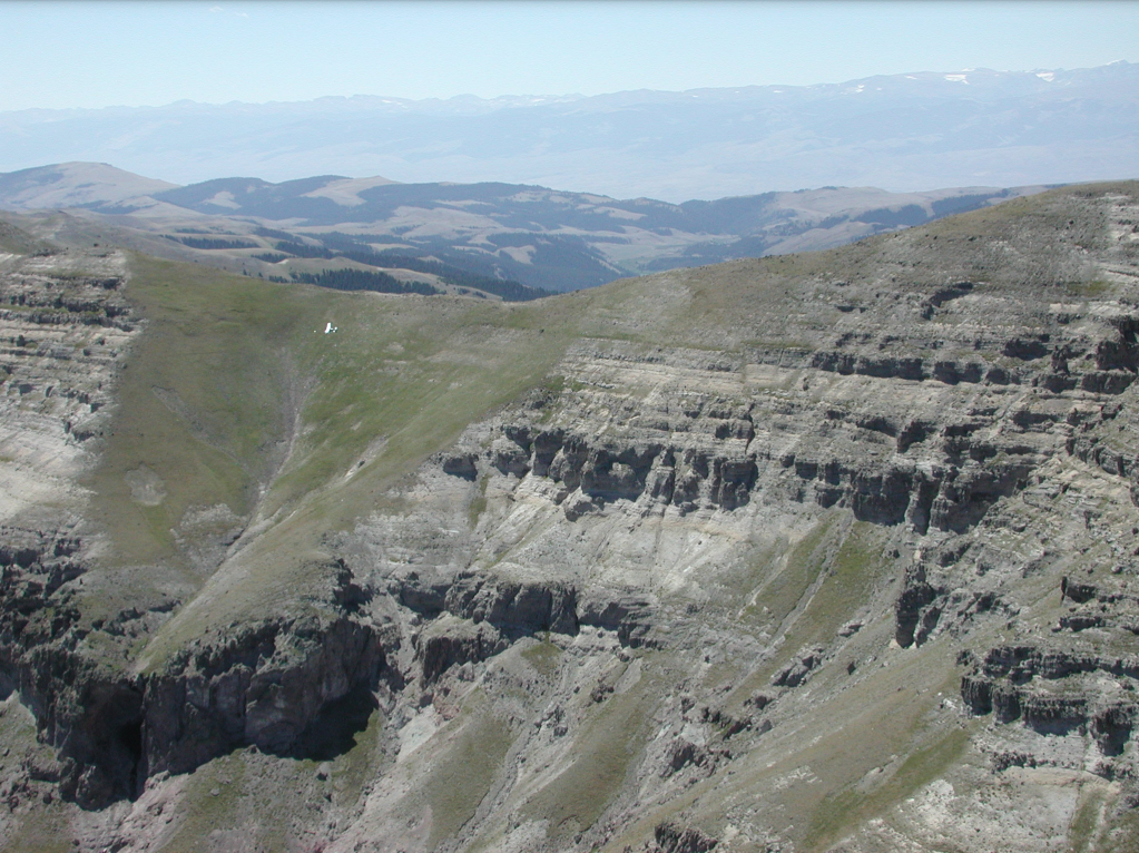
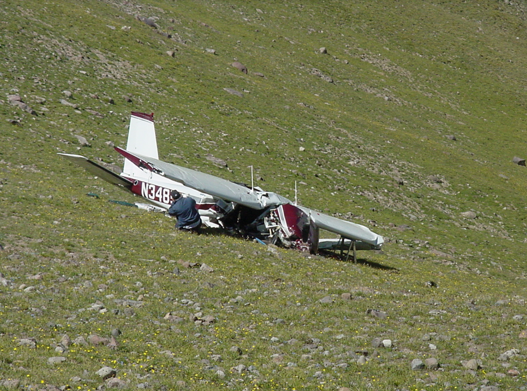
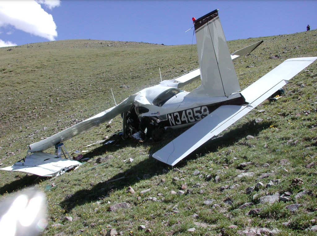
On July 27, 2002, at approximately 0740 mountain daylight time, a Cessna 177B, N34859, was destroyed when it impacted terrain while maneuvering in the Owl Creek Mountains (Wind River Reservation) near Crowheart, Wyoming. The commercial pilot and his passenger were fatally injured. The pilot was operating the airplane under Title 14 CFR Part 91. Visual meteorological conditions prevailed for the cross-country flight which originated from Worland, Wyoming, approximately 40 minutes before the accident. The pilot had activated a VFR flight plan, with Mc Call, Idaho, as its destination.
Approximately 37 minutes after departure, radar data indicates that the airplane was climbing through 10,500 feet, with a 245 degree ground track. The last radar return was approximately 4 nm from the impact point. The airplane was found approximately 100 feet below a saddle (elevation 11,200 feet) of two mountain summits. The airplane's Owner's Manual indicates that the service ceiling was 14,600 feet. The density altitude was calculated to be 12,278 feet.
Probable Cause: The pilot's failure to maintain clearance of the high mountain terrain. Contributing factors were the high mountain terrain, and the high density altitude weather condition.
Accident investigation:
 |
|
Sources:
NTSB: https://www.ntsb.gov/_layouts/ntsb.aviation/brief.aspx?ev_id=20020808X01334&key=1
Location
Images:
Revision history:
| Date/time | Contributor | Updates |
|---|---|---|
| 28-Oct-2008 00:45 | ASN archive | Added |
| 21-Dec-2016 19:24 | ASN Update Bot | Updated [Time, Damage, Category, Investigating agency] |
| 09-Dec-2017 16:53 | ASN Update Bot | Updated [Operator, Source, Narrative] |
Corrections or additions? ... Edit this accident description
The Aviation Safety Network is an exclusive service provided by:
Quick Links:
| ASN Home | Send Correction / Feedback |
| FSF Home | Disclaimer | Copyright |
| Contact Us | Privacy Policy |
| Press / Media |
 ©2024 Flight Safety Foundation