

ASN Wikibase Occurrence # 48514
This information is added by users of ASN. Neither ASN nor the Flight Safety Foundation are responsible for the completeness or correctness of this information.
If you feel this information is incomplete or incorrect, you can submit corrected information.
| Date: | Friday 21 November 2008 |
| Time: | 11:30 |
| Type: |  Cessna 170B |
| Owner/operator: | Craig T Weaver |
| Registration: | N8387N |
| MSN: | 25239 |
| Total airframe hrs: | 6195 hours |
| Engine model: | Teledyne Continental O-300 |
| Fatalities: | Fatalities: 1 / Occupants: 3 |
| Aircraft damage: | Substantial |
| Category: | Accident |
| Location: | 12 nm NW of Hanna, UT -
 United States of America United States of America
|
| Phase: | En route |
| Nature: | Private |
| Departure airport: | Salt Lake City, UT (SLC) |
| Rifle, CO (RIL) | |
| Investigating agency: | NTSB |
| Confidence Rating: |
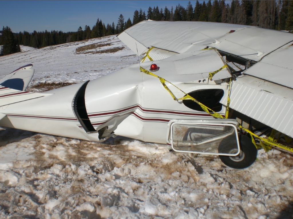
The pilot checked the weather forecast twice prior to departing on the cross-country flight, with both reports indicating that visual flight rule (VFR) conditions would prevail. The pilot stated that after taking off and climbing to an altitude of 10,500 feet mean sea level (msl), he was able to survey the approaching mountain and its summit, and initiate a rate of climb that would clear the terrain. As the flight approached the mountain, the flight encountered increasing tailwinds that reduced the effective altitude gain over distance traveled to an amount insufficient to clear the terrain. The pilot reported that as the mountain range approached he encountered unusually strong downdrafts in relation to terrain contours leading to the summit. The pilot further stated, "...we also began experiencing a loss in altitude, speed, and rate of climb, as well as increasingly adverse terrain, causing our speed to become too slow for a safe turn without further loss of control or altitude with the increasing elevation." As the airplane was losing altitude, the pilot elected to pick out a clearing to make a forced landing, as the airspeed was too low for an evasive maneuver. The airplane impacted terrain in a snow-covered clearing at an elevation of 9,800 feet msl, coming to rest upright in an open meadow surrounded by mountainous terrain about 150 feet from the initial touchdown point. The airplane sustained substantial damage to both wings and fuselage. The pilot reported no mechanical failures or malfunctions with the airplane at the time of the accident.
Probable Cause: The flight's encounter with adverse tailwinds and downdrafts in mountainous terrain that exceeded the airplane's climb capability.
Accident investigation:
 |
|
Sources:
NTSB
Location
Images:
(c) NTSB
Revision history:
| Date/time | Contributor | Updates |
|---|---|---|
| 25-Nov-2008 10:58 | JINX | Updated |
| 08-Jun-2009 12:17 | harro | Updated |
| 03-Dec-2017 13:09 | ASN Update Bot | Updated [Time, Cn, Operator, Other fatalities, Departure airport, Destination airport, Source, Narrative] |
Corrections or additions? ... Edit this accident description
The Aviation Safety Network is an exclusive service provided by:
Quick Links:
| ASN Home | Send Correction / Feedback |
| FSF Home | Disclaimer | Copyright |
| Contact Us | Privacy Policy |
| Press / Media |
 ©2024 Flight Safety Foundation